(Updated) 2025 Tropical Storm & Typhoon Season Outlook: Northwest Pacific & North Indian Ocean
Vessels and fleets face elevated risks during the critical September-December period as typhoon activity in the Northwest Pacific tracks near normal levels while cyclone conditions in the North Indian Ocean favor increased post-monsoon activity.
Weathernews' seasonal outlook update reveals conditions with heightened maritime risks during the traditional autumn peak period, with particular concerns for shipping routes around Japan and throughout the Bay of Bengal.
1. Northwest Pacific Typhoon Season Recap & Outlook
As of August 21, 12 typhoons have formed in the first half of the season, with the possibility of about one more forming in August. This is nearly the same pace as the annual average of 13.6.
For the second half of the season, around 11 formations are expected, which is near the normal average.
The total number of typhoons for the year is forecast to be around 24, which is on par with the annual average of 25.1.
Typhoon Risk Forecast for Japan
Mainland Japan (Hokkaido, Honshu, Shikoku, Kyushu):
- 4 typhoon approaches (storms passing within 300km) expected from September onward
- September: Average activity expected
- October: About one more than average
Okinawa & Amami Region:
- 5 typhoon approaches (storms passing within 300km) expected from September onward
- About one more approach than the average expected for both September and October
Critical Risk Factors
Because the Pacific high-pressure system is forecast to be stronger than normal, there is a possibility that typhoons could approach Japan later in the season than usual, creating a risk that they could approach the country in a short period of time after formation.
Regional Storm Track Trends
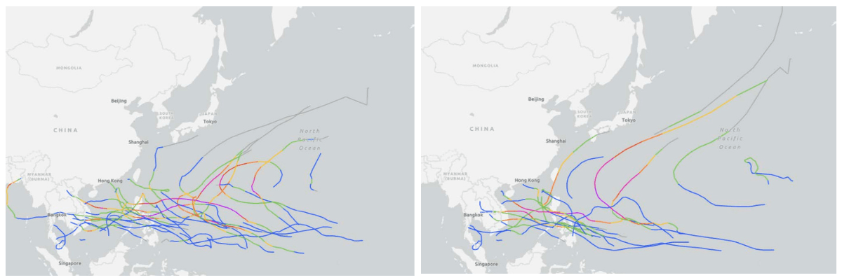
September Risk Areas and Tracks: During similar years, storms have been observed tracking into the South China Sea and southern China, in addition to those moving from the East China Sea toward the Yellow Sea and near Honshu.
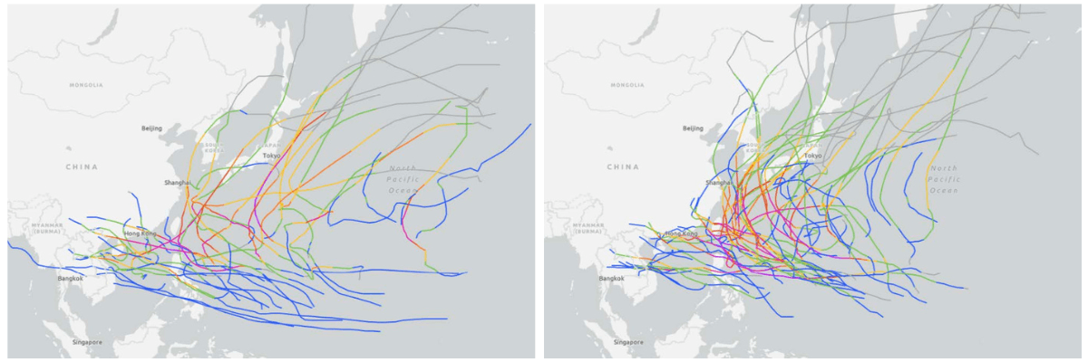
TS track maps for September. Left: Similar years (2021, 2017, 2000, 1996, 1995). Right: The last 10 years (2015-2024). (Source: NOAA)
October Risk Areas and Tracks: In similar years, some storms are observed heading toward the South China Sea, while others are seen moving toward the Nansei Islands and near Honshu.
TS track maps for October. Left: Similar years (2021, 2017, 2000, 1996, 1995). Right: The last 10 years (2015-2024). (Source: NOAA)
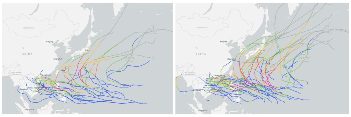
November Risk Areas and Tracks: During similar years, storms tend to move toward the South China Sea, but some are also seen changing direction to pass over the ocean southeast of Japan.
TS track maps for November. Left: Similar years (2021, 2017, 2000, 1996, 1995). Right: The last 10 years (2015-2024). (Source: NOAA)
2. North Indian Ocean Cyclone Season Outlook
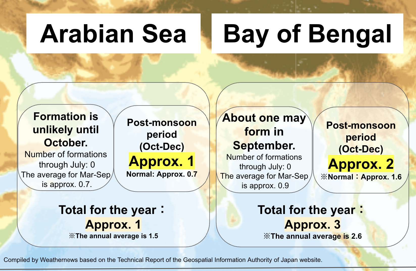
Cyclones form more frequently during the October-December post-monsoon season than other periods. Conditions in September 2025 favor increased activity over the Bay of Bengal due to enhanced storm development conditions and favorable high-altitude wind patterns.
Bay of Bengal Forecast
While storm formation is uncommon during the monsoon season, conditions in September tend to be more favorable than average, with about one formation expected. This is because of enhanced thunderstorm activity and low vertical wind shear over the Bay of Bengal.
For the post-monsoon period (October-December), approximately 2 additional systems are forecast for the Bay of Bengal.
Annual total for Bay of Bengal: Approximately 3 (normal: 2.6)
Arabian Sea Forecast
Formation is unlikely until October. For the post-monsoon period (October-December), approximately 1 formation is forecast for the Arabian Sea (normal: 0.73).
Annual total for Arabian Sea: Approximately 1 (normal: 1.5)
Maritime Industry Impact Assessment
Northwest Pacific Shipping Risks
East China Sea Corridors (High Risk):
- September-October: Multiple storm paths affecting major shipping lanes
- October: Elevated risk for routes between the Philippines and southern Japan
- Potential for reduced storm warning lead times due to closer-to-shore formation patterns
South China Sea Routes (Moderate-High Risk):
- September-November: Consistent risk throughout the autumn period
- Track patterns favor westward movement into these shipping corridors
- November: Continued risks with some systems affecting routes southeast of Japan
Japanese Waters and Coastal Areas (High Risk in October):
- Peak approach risk during October (above normal activity expected)
- Extended risk period due to stronger Pacific high-pressure system
- Potential for storms forming closer to Japan, reducing preparation time
North Indian Ocean Maritime Risks
Bay of Bengal (Higher Risk):
- September transition period: One storm expected as monsoon weakens
- October-December: Peak cyclone season with 2 additional systems forecast
- Critical shipping routes between India, Bangladesh, and Southeast Asia face elevated exposure
Arabian Sea (Moderate Risk):
- October-December: Approximately one storm expected
- Lower overall activity compared to Bay of Bengal
- Routes between Persian Gulf and Indian subcontinent may be affected
Seasonal Risk Timing: The post-monsoon season (October-December) typically sees higher storm activity than the pre-monsoon period, requiring heightened maritime preparedness during this critical trade period.

Weather Pattern Drivers Behind the Forecast
Pacific Ocean Conditions
From the summer of 2024 through the summer of 2025, ENSO-neutral conditions persisted. However, the sea surface temperature distribution was similar to that of a La Niña event. For the latter half of the season (September-November), ENSO-neutral conditions are expected to continue (with approximately 48% probability), but there is also a significant chance of conditions becoming more La Niña-like (approximately 47% probability).
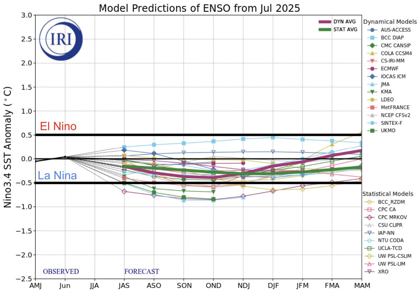
Estimated SST anomalies in El Nino monitoring areas based on national models (Source: the International Research Institute (IRI).)
Indian Ocean Temperature Patterns
A negative Indian Ocean Dipole event is expected to develop from the summer through the autumn of 2025. During such an event, sea surface temperatures tend to be warmer than average in the eastern Indian Ocean and cooler than average in the western part.
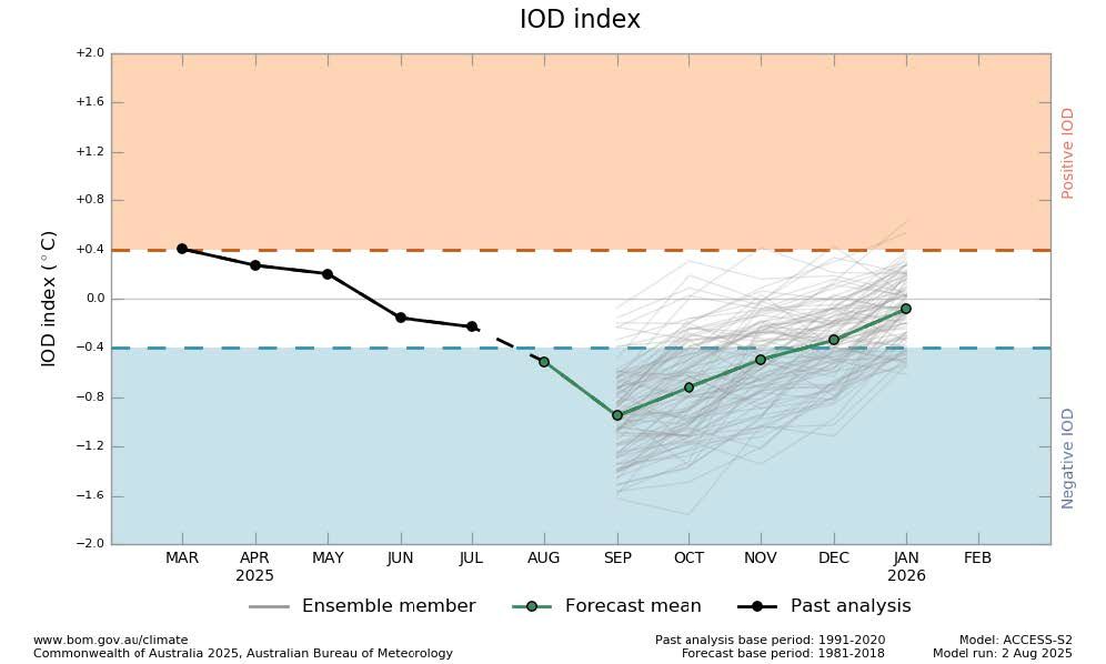
Figure 2-1:The forecast of Indian Ocean Dipole Mode (Source:Bureau of Meteorology)
Late Season Atmospheric Conditions (September-November)
Sea Surface Temperatures:
- Northwest Pacific: Higher than average in the western part and near average in the eastern part
- Indian Ocean: Slightly higher than average in the Bay of Bengal area, near average in the Arabian Sea
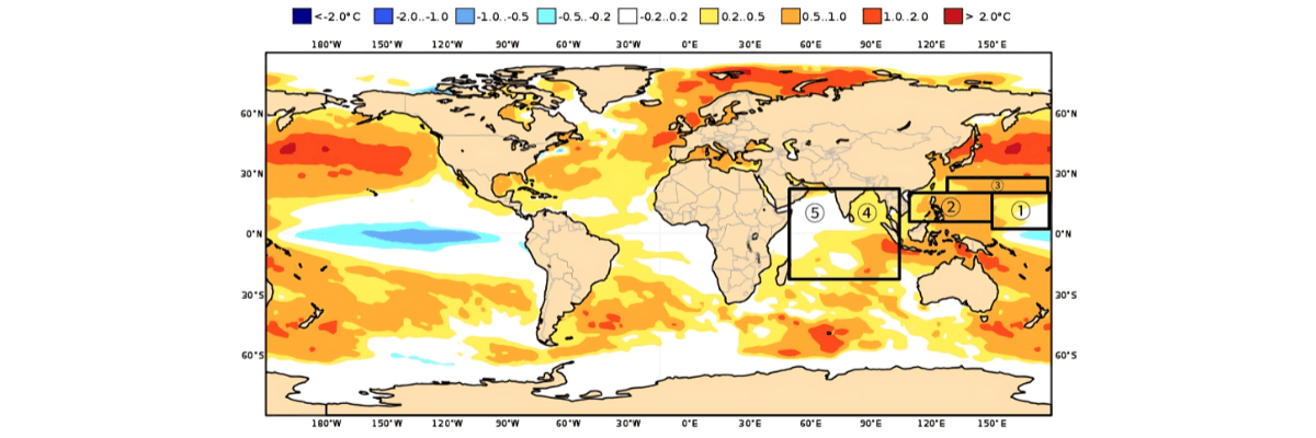
Three-month average sea surface temperature anomaly forecast for September-November 2025 (average of national models(ECMWF、Met Office、Meteo France、 CMCC、DWD、NCEP、JMA、ECCC、BOM)). Black frame: Main TS/CYCLONE generation area.
Storm Development Conditions:
- Bay of Bengal: More active thunderstorm conditions than normal expected
- Arabian Sea: Above average vertical wind shear (less favorable for storm development)
- Bay of Bengal: Below average vertical wind shear (more favorable for storm development)
Subtropical High Forecast
The Subtropical High is expected to retreat later than usual during the forecast period.
Summary
The September-December period presents elevated risks for maritime operations, with October marking peak typhoon activity around Japan and the Bay of Bengal entering its most active cyclone season. Vessels operating in East China Sea corridors, South China Sea routes, and Bay of Bengal shipping lanes should prepare for above-normal storm activity during these critical months.
Weather Routing Expertise
Weathernews provides recognized routing guidance and real-time weather intelligence to help maritime clients navigate challenging conditions safely and efficiently. Our meteorologists and voyage planners deliver customized solutions for vessel-specific needs during high-risk periods.