The maritime industry just got a significant advancement in storm preparedness! We are introducing you to our latest innovation: Tropical Storm (TS) Risk Probability—a proprietary forecasting function that spots potential tropical storm formation areas up to 15 days before official forecasts are issued. That means you get ample time to plan alternative routes and stay ahead of the weather.
Early Warning, Better Decisions
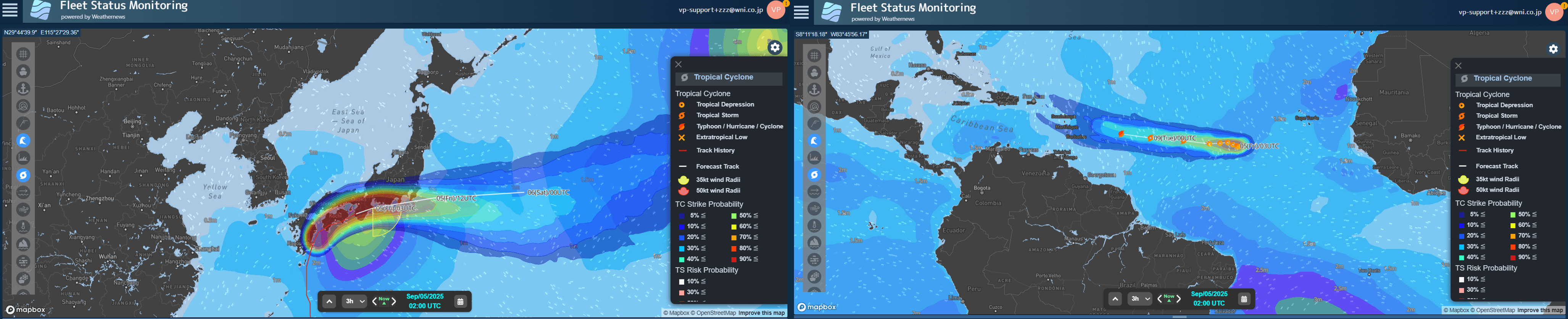
Available through Weathernews' SeaNavigator platform, the new feature helps our customers who need to make critical operational decisions well in advance. The prediction updates twice daily with four probability levels, allowing users to quantitatively assess storm formation risks along their planned routes, ports and work sites.
"Users can now check the risk of a tropical storm forming [along their shipping route] before it actually occurs. For instance, if there's a 50% TS risk in the South China Sea within 10 days, operators can immediately begin discussing alternative routes with stakeholders—long before they'd typically start contingency planning,” explains Toshio, one of our senior voyage analysts.
From Verbal to Visual: Enhancing Storm Risk Communication
Every summer, we receive numerous inquiries from voyage planners, marine engineers, captains, shipowners, and offshore energy contractors asking: Where might tropical storms form? When? And which routes will be affected?
Our customers need to understand severe weather risks for their specific routes, ports, and offshore work sites—assessing potential delays, operational changes, and safety measures before storms develop.
Here's the challenge: Unlike official storm tracking charts, "suspect areas" or "invest areas" have no visual documentation before storms actually form. We were communicating these risks through phone calls and briefings, making it difficult for customers to visualize risk zones and understand potential impacts on their operations.
That's why we developed this content. Working with our Forecast Center team, we've transformed verbal communications into clear, visual tools that make critical storm risk information easily accessible.
Beyond Free Weather Services
While free resources like the National Hurricane Center provide valuable information, Weathernews' TS Risk Probability offers a more comprehensive approach. This tool combines analytical knowledge from both NCEP and ECMWF ensemble members with expertise from our experienced team of meteorologists at the Global Storm Center, creating a larger, more robust dataset than single-source forecasts. Our global track record demonstrates consistent leading performance: we ranked No. 1 for track forecast accuracy in both Northern Hemisphere (2024) and Southern Hemisphere (2022-2023) analyses, and achieved top-tier intensity forecasting across both regions when compared to RSMC and JTWC.
A Two-Pronged Approach
Here's where it gets particularly effective. The platform also features Tropical Cyclone (TC) Strike Probability, which works hand-in-hand with TS Risk Probability for complete storm planning coverage. Here's your game plan:
- Before official storm forecasts begin: Use TS Risk Probability to spot potential formation areas up to 15 days ahead along your planned routes.
- Once a storm develops: Switch to TC Strike Probability to assess path variations and forecast changes—helping you decide if your current route is still your best bet.
This dual approach transforms storm planning from reactive to proactive, giving maritime operators the data they need to make informed decisions well before weather becomes a crisis.
The Bigger Picture: Complete Tropical Storm Support
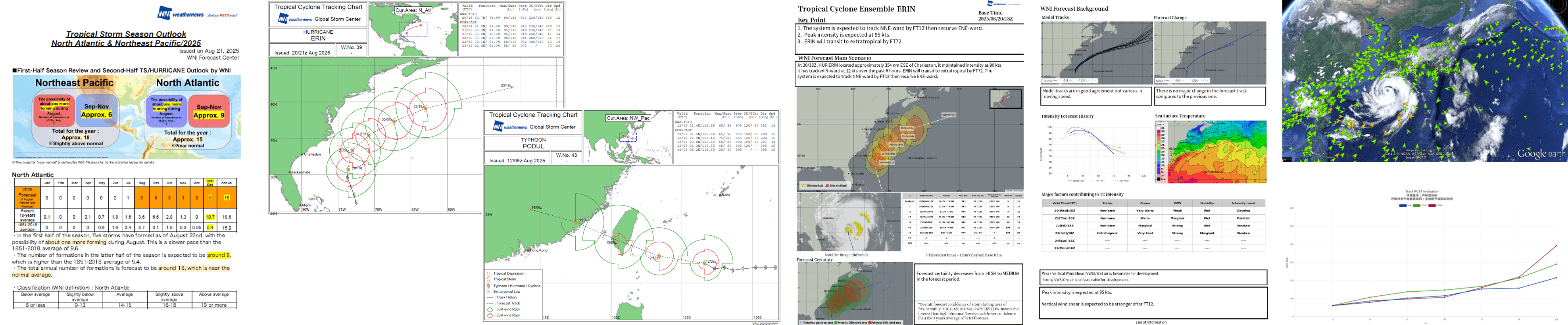
TS Risk Probability and TC Strike Probability are just two elements of our comprehensive storm support approach. Here's how our complete tropical storm support works to keep you prepared year-round.
- Before the Season Starts: We kick things off with detailed seasonal outlooks covering all oceanic basins—not just statistical predictions, but your strategic planning foundation.
- When Storms Develop: Our Global Storm Center maintains continuous monitoring and analysis worldwide. Every six hours, we issue updated tropical cyclone tracking charts and forecasts. But here's what sets us apart: our meteorologists—with over 40 years of combined experience—integrate real-time satellite imagery with actual observations from our global network of client vessels at sea.
- What makes our approach unique? Every tracking chart comes with Ensemble forecast discussions that ensure your entire team understands not just what's happening, but why it matters for your specific operations.
- After Each Storm: Our commitment doesn't end when storms dissipate. We conduct comprehensive internal performance analyses comparing our accuracy against major agencies. This continuous evaluation drives improvements that benefit you through enhanced precision in future forecasts.
- Your Complete Support Flow: Seasonal Outlook → TS Risk Probability → Real-time TC Charts & Ensemble Discussions → TC Strike Probability → Mid-season Updates → Enhanced Future Forecasts
For maritime professionals seeking to integrate advanced storm risk assessment into their operational planning, our team can guide you on implementing these tools within existing workflow processes. Contact us to discuss how TS Risk Probability fits your specific operational requirements.