North Atlantic and North Pacific Storm Trend Outlook
(November 2025 - January 2026)
Our latest analysis on ocean weather patterns reveals evolving storm developments, shifting pressure systems, and critical implications for maritime routing operations in the months ahead.
North Pacific Storm Outlook
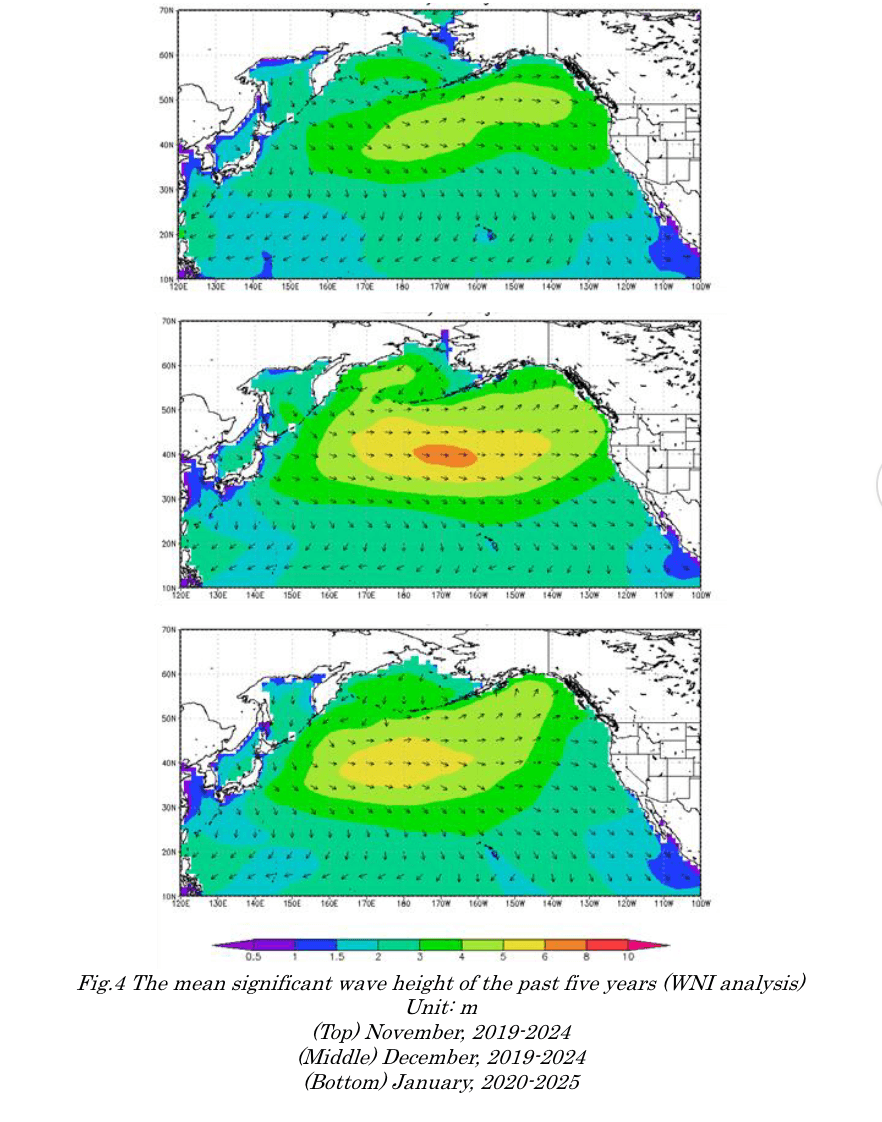
Key highlights of the north pacific forecast include persistent stormy conditions around Japan and the Kuril Islands throughout December and January, while November will see the primary storm activity concentrated around the Bering Sea and extending from the East China Sea to the South China Sea.
Notably, this traditional seasonal progression now exhibits intensified peak wave heights and earlier onset of severe conditions compared to historical norms, as shown in our analysis.

November 2025
Primary storm zones: Bering Sea region and East China Sea to South China Sea corridor
Weather conditions:
- Frequent low-pressure development around the Bering Sea and Gulf of Alaska
- Amplified continental high-pressure system strengthening the northeast monsoon
- Challenging conditions for coastal and offshore operations across East Asia
- Low pressure expected to develop around the Bering Sea and Gulf of Alaska, making severe weather more likely along northern shipping corridors
Shipping route impacts: Expect significant disruptions to Bering Sea trans-Pacific routes and busy Asia-Pacific trade corridors through East/South China Seas
December 2025
Primary storm zones: Japan to Kuril Islands region and around Hawaii
Weather conditions:
- High pressure intensifies northwest of North America
- Below-normal pressure develops around Japan, the Kuril Islands, and Hawaii
- Strengthened winter pressure patterns near Japan
- Continued rough trans-Pacific conditions
Shipping route impacts: Japan-Kuril shipping lanes and mid-Pacific routes via Hawaii face severe weather disruptions
January 2026
Primary storm zones: Japan to Kuril Islands region and around Hawaii
Weather conditions:
- Higher-than-normal pressure near the Aleutian Islands
- Lower-than-normal pressure near Japan and the Kuril Islands
- Ongoing severe weather likely in northern Pacific routes
Shipping route impacts: Continued Japan-Kuril disruptions with additional impacts on North Pacific routes serving northwestern North American ports
North Atlantic Storm Outlook
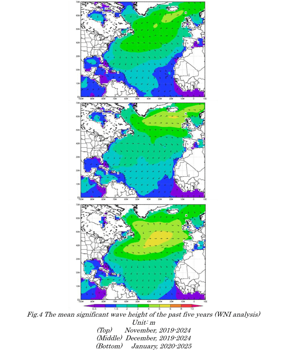
The outlook reveals a progressive eastward shift in storm activity throughout the winter season, beginning in the western North Atlantic and culminating with widespread severe weather across the eastern Atlantic, Europe, and Mediterranean by January.
Historical wave height analysis supports the above forecast, as although previous years have shown significant wave height activity generally concentrated in the central Atlantic, this season's forecast represents a notable departure from these normal patterns, with activity extending into European and Mediterranean waters.

November 2025
Primary storm zones: Western North Atlantic
Weather conditions:
- Strengthened Azores High: Higher-than-average pressure over eastern North Atlantic
- Lower pressure dominates western basin: More storms near North America
- Europe & Mediterranean: Fewer storms than average
Shipping route impacts: Disruptions expected on trans-Atlantic routes via western approaches and North American coastal shipping lanes
December 2025
Primary storm zones: Eastern North Atlantic
Weather conditions:
- Azores High weakens, while low pressure expands into the eastern Atlantic
- More storm systems redirected toward Europe
- Mediterranean remains near-normal in storm activity
Shipping route impacts: Severe weather impacts shift to eastern trans-Atlantic routes and European coastal shipping corridors
January 2026
Primary storm zones: Eastern North Atlantic, around Europe, and Mediterranean Sea
Weather conditions:
- Significantly weakened Azores High and widespread low pressure across the basin
- Elevated storm activity across Europe and adjacent waters
- Trans-Atlantic routes face heavy seas and operational challenges
Shipping route impacts: Extensive disruptions across European shipping lanes, Mediterranean routes, and all eastern Atlantic maritime corridors


