North Pacific and North Atlantic Storm Trend Outlook (January 2026 - April 2026)
The maritime industry faces shifting storm patterns across the North Pacific and North Atlantic through the first four months of 2026, with intensified activity in the eastern Atlantic and persistent rough conditions in western Pacific waters.
North Pacific Storm Outlook
The western North Pacific experiences sustained stormy conditions throughout the period, with primary activity centered around Japan and the Kamchatka Peninsula in January and February, then expanding to include Hawaiian waters by March. The East China Sea and South China Sea face normal to strong northeast monsoon conditions through the period.
This period's forecast shows storm intensity remaining elevated longer than typical seasonal patterns, with severe weather persisting through March rather than tapering in late winter as historical data would suggest.
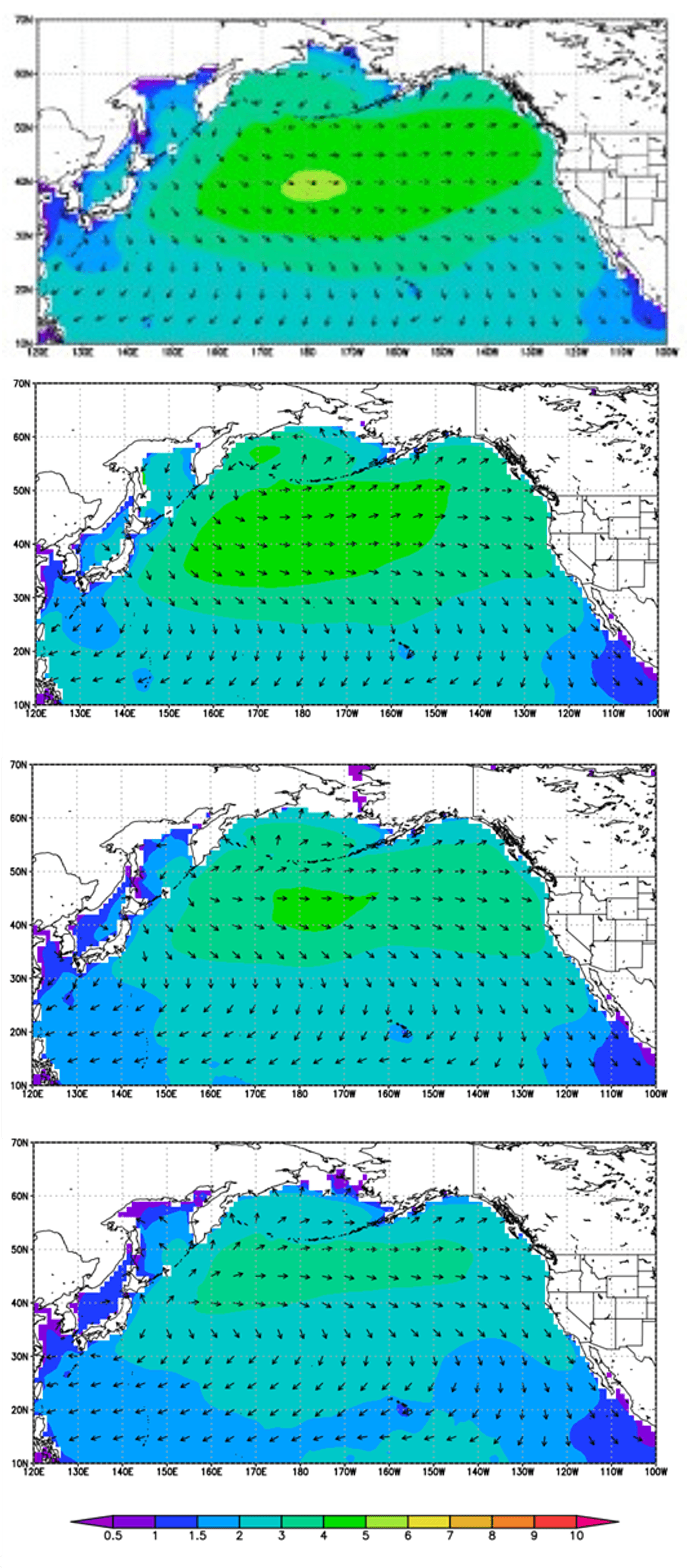
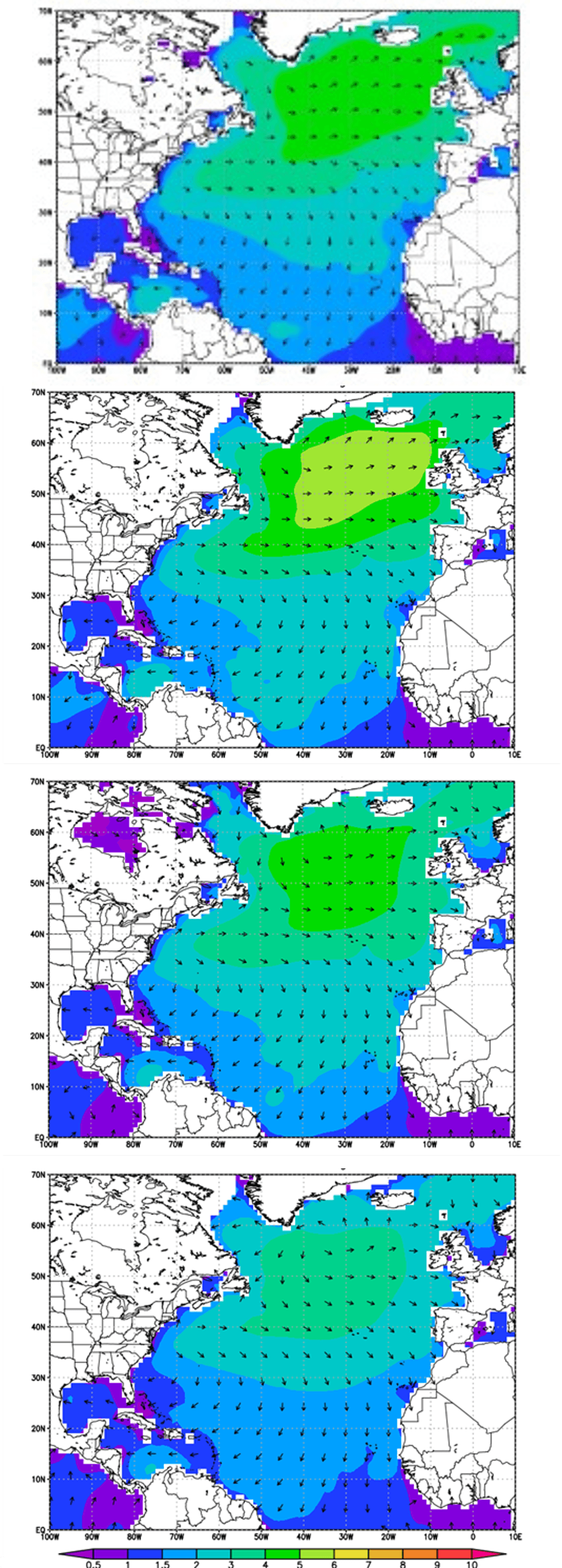
The mean significant wave height of the past five years (WNI analysis)
- Unit: m
- (1) January, 2020-2024
- (2) February, 2021-2025
- (3) March, 2021-2025
- (4) April, 2021-2025
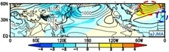
North Pacific, January 2026
Primary storm zones: Western North Pacific, East China Sea to South China Sea, Philippine Sea
Weather conditions:
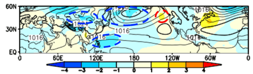
- Higher-than-normal pressure around the Bering Sea and Aleutian Islands
- Lower-than-normal pressure near the Kamchatka Peninsula and Japan
- Winter pressure patterns intensify around Japan with developing low-pressure systems
- Northeast monsoon strengthens across the East China Sea and South China Sea
Shipping route impacts: Vessels operating near Japan and the Kamchatka Peninsula face increased storm frequency and rough seas. Trans-Pacific routes through these waters require additional weather routing consideration. Strong monsoon conditions create challenging coastal operations across East and Southeast Asian waters.
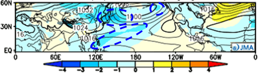
Monthly sea level pressure anomaly simulation for Jan. 2026 (JMA). ※Yellow indicates higher pressure, and blue indicates lower pressure compared with the normal year. Unit: hPa
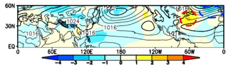
North Pacific, February 2026
Primary storm zones: Around Bering Sea to Aleutian Islands, Philippine Sea
Weather conditions:
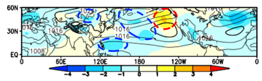
- Higher than normal atmospheric pressure is predicted west of the North American continent
- Lower-than-normal atmospheric pressure is expected from the western to central North Pacific
- Due to these pressure trends, low pressure is likely to develop toward the Bering Sea, making stormy weather more likely
- Additionally, because atmospheric pressure over the Chinese continent and the Philippine Sea is likely to be lower than normal, the northeast monsoon over the East China Sea and South China Sea is expected to be normal
Shipping route impacts: Vessels in the Bering Sea and Aleutian Islands region face increased storm development and rough conditions. Western Pacific routes encounter stormy weather with low-pressure systems. Monsoon activity in the East China Sea and South China Sea remains at normal levels, providing relatively stable conditions for regional shipping operations compared to elevated activity in northern routes.
Monthly sea level pressure anomaly simulation for Feb. 2026 (JMA). Unit: hPa
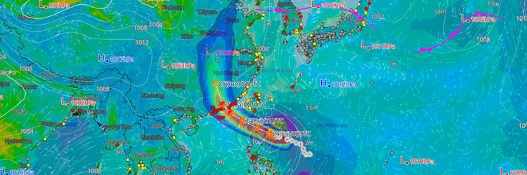
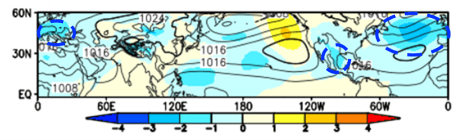
North Pacific, March 2026
Primary storm zones: Around Aleutian Islands, Around Hawaii, Philippine Sea
Weather conditions:
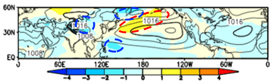
- Higher-than-normal pressure is forecast to continue in the Gulf of Alaska and west of the North American continent
- Lower-than-normal pressure is forecast in the western to central North Pacific
- Due to the these trends, low pressure is expected to develop in the Aleutian Islands and around Hawaii, making stormy weather more likely
- As for the northeast monsoon, lower-than-normal pressure is expected over the Chinese continent and the Philippine Sea, so it is expected to be normal over the East China Sea and South China Sea
Shipping route impacts: Storm activity expands to mid-Pacific routes around Hawaii and the Aleutian Islands while western Pacific conditions remain active. Japan-Hawaii shipping lanes face increased severe weather with developing low-pressure systems in both regions. The East China Sea and South China Sea continue normal monsoon patterns, maintaining stable conditions for coastal and regional trade routes.
Monthly sea level pressure anomaly simulation for Mar. 2026 (JMA). Unit: hPa
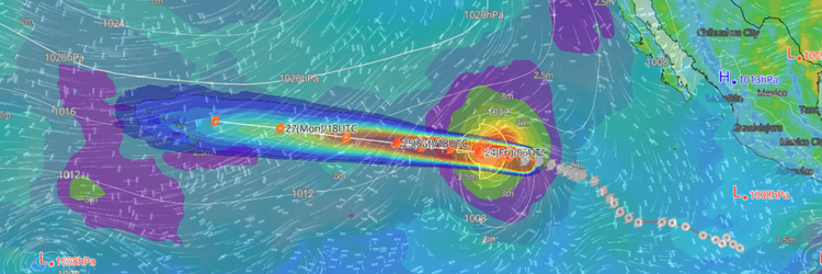
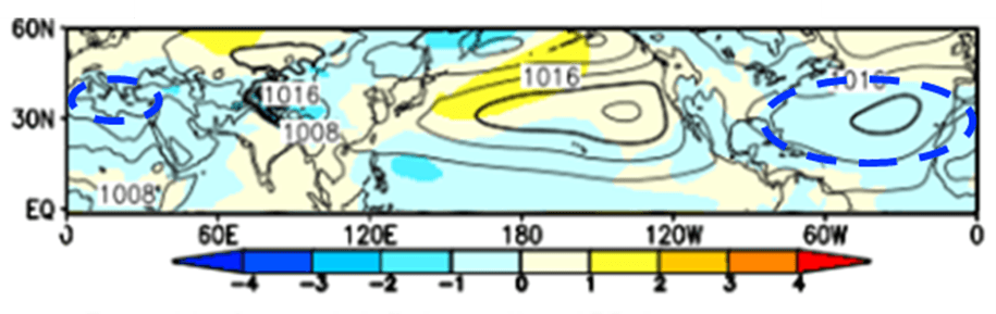
North Pacific, April 2026
Primary storm zones: Around Kamchatka Peninsula, Philippine Sea
Weather conditions:
- Higher-than-average atmospheric pressure is predicted in the mid-latitudes of the North Pacific
- Lower pressure is predicted around the Kamchatka Peninsula
- This will likely lead to the development of low pressure in the Kamchatka area, making stormy weather more likely
- The northeast monsoon is expected to follow a similar pattern to March, with normal conditions expected in the East and South China Seas
Shipping route impacts: Northern Pacific routes near the Kamchatka Peninsula face elevated storm activity with frequent low-pressure development. Mid-Pacific shipping benefits from stable high-pressure conditions. The East China Sea and South China Sea experience normal seasonal patterns, providing predictable conditions for regional maritime operations.
Monthly sea level pressure anomaly simulation for Apr. 2026 (JMA). Unit: hPa
North Atlantic Storm Outlook
The North Atlantic exhibits a progressive shift toward increased storm activity in the eastern basin throughout the period. While January brings elevated conditions to the northeastern Atlantic and Mediterranean, February and March see this pattern intensify and expand, with the Azores High remaining strong through February before weakening in March, allowing more frequent low-pressure systems to impact European waters.
This forecast marks a departure from typical late-winter patterns, which usually see storm activity beginning to moderate by March. Instead, the eastern Atlantic and Mediterranean remain active through the period, with conditions in March resembling peak winter rather than early spring patterns.
The mean significant wave height of the past five years (WNI analysis)
- Unit: m
- (1) January, 2020-2024
- (2) February, 2021-2025
- (3) March, 2021-2025
- (4) April, 2021-2025
North Atlantic, January 2026
Primary storm zones: Northeastern North Atlantic, Europe to Mediterranean Sea
Weather conditions:
- Stronger-than-average Azores High in the mid-latitude Atlantic
- Below-normal pressure in northeastern North Atlantic and North Sea
- Lower-than-average pressure across the Mediterranean Sea
- Frequent severe weather in northeastern regions
Shipping route impacts: Northern European routes and North Sea operations face more frequent weather disruptions than typical January conditions. Mediterranean shipping encounters above-average storm activity. Central Atlantic routes benefit from stable high-pressure conditions.
Monthly sea level pressure anomaly simulation for Jan. 2026 (JMA). ※Yellow indicates higher pressure, and blue indicates lower pressure compared with the normal year. Unit: hPa
North Atlantic, February 2026
Primary storm zones: West of Ireland, Around Europe
Weather conditions:
- Higher-than-average pressure is expected in the western North Atlantic
- As a result, the strength of the Azores High is likely to be normal
- Meanwhile, lower-than-average pressure in the northeastern North Atlantic is expected, leading to low pressure developing towards west Ireland and Europe, making stormy weather more likely
- Pressure in the Mediterranean Sea is normal, so stormy weather is expected to be normal
Shipping route impacts: Western European routes and Irish waters face increased storm frequency with developing low-pressure systems. Northern European shipping lanes experience above-average weather disruptions. Mediterranean operations encounter normal seasonal conditions. Central and western Atlantic routes benefit from stable pressure patterns.
Monthly sea level pressure anomaly simulation for Feb. 2026 (JMA). Unit: hPa
North Atlantic, March 2026
Primary storm zones: Central to Eastern North Atlantic, Europe to Mediterranean Sea, Gulf of Mexico
Weather conditions:
- Lower-than-normal atmospheric pressure is predicted across a wide area of the central to eastern North Atlantic and the Gulf of Mexico
- This will likely result in more severe weather over the western ocean from Ireland to the Iberian Peninsula, Europe, and the Gulf of Mexico
- Lower-than-normal atmospheric pressure in the Mediterranean is expected to result in more severe weather than normal
Shipping route impacts: Central and eastern Atlantic routes face elevated severe weather with widespread low-pressure systems from Ireland to the Iberian Peninsula. European shipping lanes and Mediterranean operations experience above-normal storm activity and disruptions. Gulf of Mexico routes encounter increased weather challenges. Western Atlantic routes may see some impacts from the expanded low-pressure pattern.
Monthly sea level pressure anomaly simulation for Mar. 2026 (JMA). Unit: hPa
North Atlantic, April 2026
Primary storm zones: Middle latitude of North Atlantic, Mediterranean Sea, Gulf of Mexico
Weather conditions:
- Lower-than-normal atmospheric pressure is predicted in the mid-latitudes of the North Atlantic
- This could lead to a weaker-than-normal Azores High and more severe weather than normal in the mid-latitudes of the North Atlantic, the Mediterranean Sea, and the Gulf of Mexico
Shipping route impacts: Mid-latitude Atlantic routes face increased storm activity with a weakened Azores High allowing more frequent low-pressure development. Mediterranean shipping continues experiencing above-normal weather disruptions into spring. Gulf of Mexico operations encounter elevated severe weather conditions. Northern and southern Atlantic routes may benefit from more stable conditions outside the primary storm zones.
Monthly sea level pressure anomaly simulation for Apr. 2026 (JMA). Unit: hPa