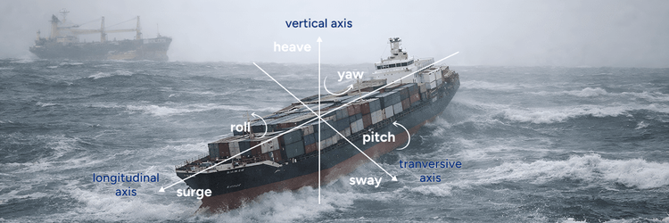
Maritime weather forecasting operates in one of the most dynamic environments on Earth, where conditions can evolve rapidly and accurate predictions become the foundation of safe, efficient operations. As weather patterns grow increasingly complex, the demand for even more precise, reliable forecasting continues to rise—driving continuous innovation in how we deliver weather intelligence to our clients.
The Challenge: Identifying the Next Breakthrough
Weathernews' existing forecasting model provides industry-leading weather intelligence for maritime operations. Our new model builds on this foundation by unifying the methodology behind probabilistic and deterministic forecasts, eliminating the occasional inconsistencies that could arise when these two perspectives—both essential for safe routing—were derived separately.
This refinement addresses real operational needs. In January 2026, several challenging weather scenarios across global shipping routes demonstrated opportunities for even earlier detection and more precise forecasting—spurring our development of enhanced capabilities that push accuracy boundaries further.
The Solution: Enhanced Detection Through Unified Intelligence
Our new forecasting model, launching in March 2026, represents a significant advancement in methodology. Both probabilistic and deterministic forecasts now derive from the same source: an ensemble of 82 global weather models.
The model provides a 16-day forecast window with updates every 6 hours, analyzing the collective output from all 82 perspectives to derive the optimal forecast value. This unified approach ensures that risk assessments and performance calculations work from perfectly aligned intelligence.
By synthesizing 82 model viewpoints simultaneously, the enhanced model demonstrates exceptional capability in detecting rapidly developing storms while providing more stable forecast guidance between updates—addressing two of the most challenging aspects of maritime weather forecasting.
The measurable improvements are significant: a 6% reduction in forecast error (RMSE) compared to ECMWF, an 18% reduction in forecast error (RMSE) compared to NCEP and a 5-percentage-point enhancement in the capture rate for high-wave events exceeding 6 meters. These advances translate directly into more time for decision-making and greater confidence in routing choices, particularly in extreme sea states where accuracy is most critical.
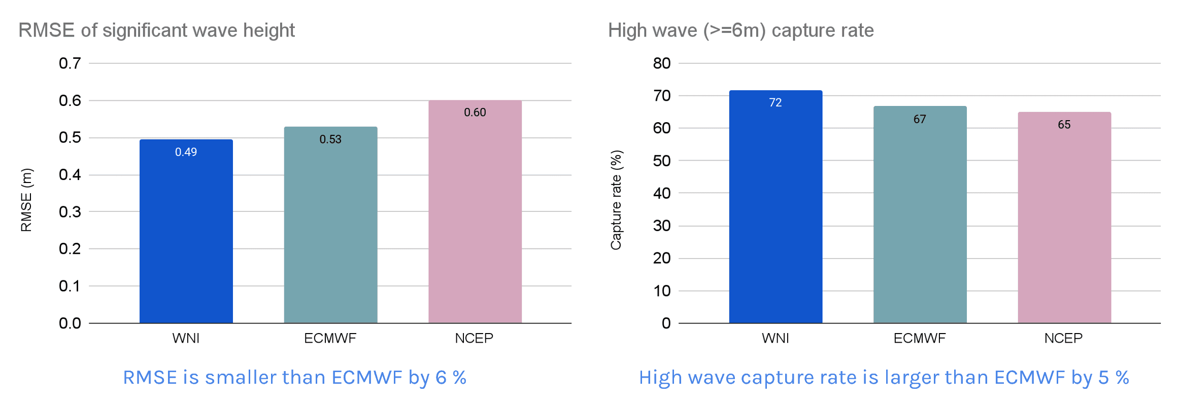
- Sea Area: Global; Period: January 8, 2026 to March 7, 2026
- Ground Truth (Reference Value): Satellite Altimetry Data
- Score: Average of scores at lead times of 24, 48, 72, 96, 120, 144, and 168 hours
Real-World Performance: Challenging Scenarios, Superior Results
SHIP A: Mediterranean Weather Event, January 10-11, 2026
The Mediterranean has historically been one of the most challenging forecasting regions due to its complex topography and localized weather patterns. SHIP A's transit on January 10-11 provided a rigorous test of the model's capabilities in this traditionally difficult area.
The vessel encountered winds of 45-65 knots and waves reaching 6 meters. Hindcast analysis using the new model demonstrates a significant improvement: it successfully captured the storm's severity and provided advance warning with greater accuracy—representing meaningful progress in a region where precise forecasting has been particularly challenging.
This regional accuracy enhancement means routing teams can now plan Mediterranean transits with greater confidence, equipped with more reliable weather intelligence for one of the world's busiest and most complex shipping corridors. Better forecasting in previously difficult regions directly translates to improved safety margins and more effective route planning.
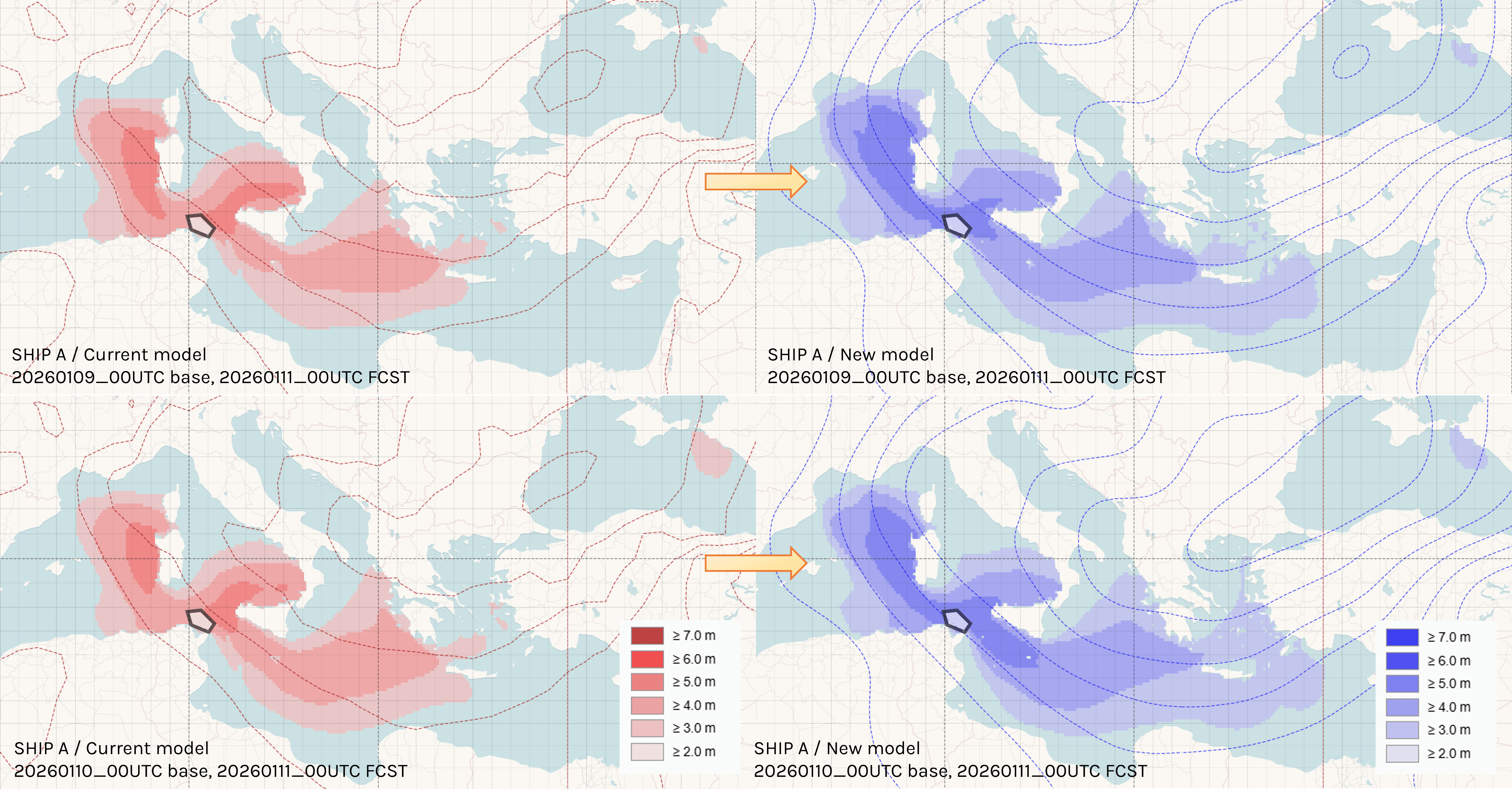
- Comparison of current and new WNI model forecasts 2 days and 1 day prior to the day encountering inclement weather
SHIP B: North Pacific Operations, January 16-17, 2026
The North Pacific south of the Aleutians presented an ideal test case for detecting rapidly developing low-pressure systems—among the most critical capabilities for maritime safety. SHIP B's encounter with rough weather on January 16-17 demonstrated the enhanced model's strength in exactly this scenario.
Hindcast analysis confirms the new model successfully identified the rapidly intensifying system and provided accurate forecasts 3 days in advance of the vessel's encounter. This early detection of "bomb cyclone" development represents a crucial safety advancement, as these systems can strengthen dramatically within 24 hours.
The three-day lead time enables optimal route selection—routing teams have sufficient time to evaluate multiple alternatives, calculate fuel implications for different paths, and choose routes that balance schedule requirements with safety considerations. This isn't just an earlier warning; it's the operational margin needed for true route optimization rather than last-minute evasive action.
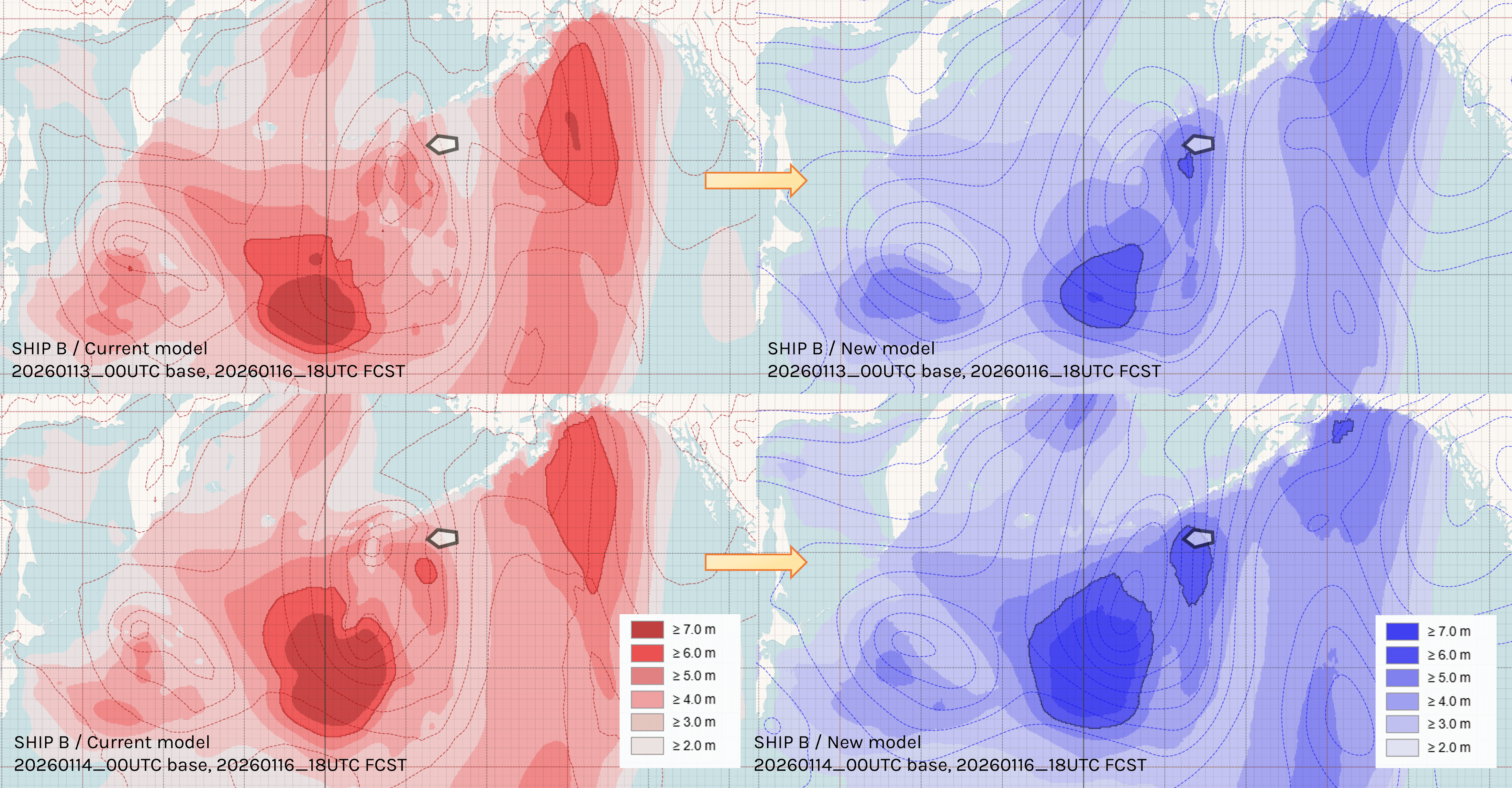
- Comparison of current and new WNI model forecasts 3 days and 2 days prior to the day encountering inclement weather
SHIP C: South Atlantic Route, January 24-25, 2026
SHIP C's South Atlantic passage on January 24-25 highlighted another critical advancement: the alignment between forecasted conditions and actual vessel observations. The ship's master reported sea states of 2.5-3.0 meters in conditions where earlier forecast approaches showed significantly calmer seas.
The new model's forecast and analysis values closely matched the vessel's reported conditions—providing data that aligns with ground truth. This alignment represents more than improved accuracy; it creates verifiable, objective performance metrics that both weather provider and vessel operator can trust.
When forecast data matches what captains actually experience at sea, it eliminates ambiguity in service quality evaluation. Shipping companies can confidently assess routing decisions and ship performance calculations knowing the weather data reflects reality. This data transparency builds operational trust and enables more accurate voyage analysis, fuel consumption tracking, and performance optimization—all dependent on weather inputs that genuinely represent conditions encountered.
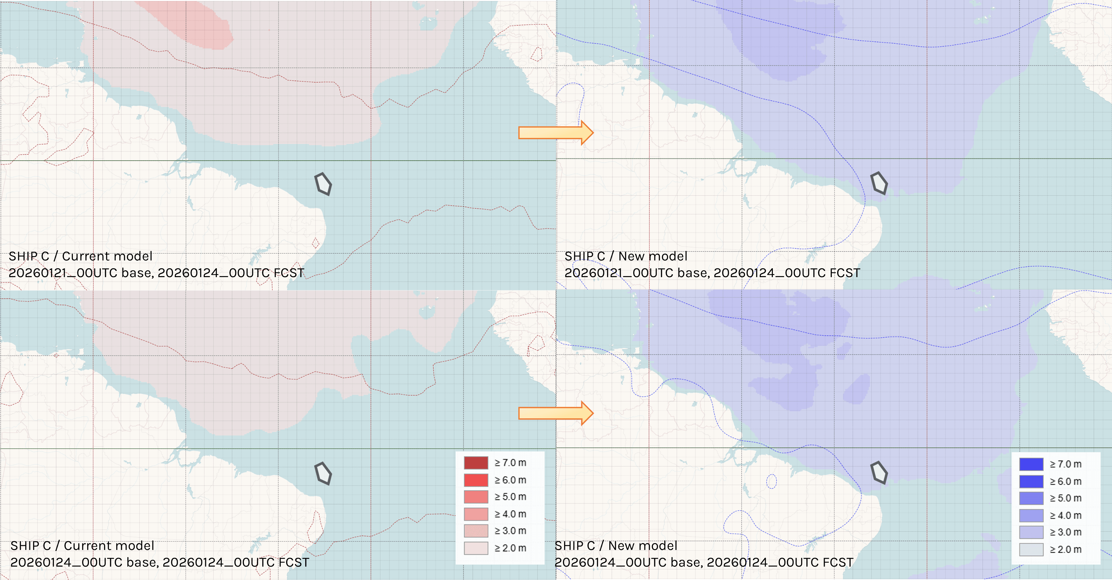
- Comparison of current and new WNI model forecasts 3 days prior to the day encountering inclement weather and analysis
What This Means for Your Operations
These challenging scenarios illuminate how forecasting enhancements translate into operational advantages:
More confident decisions underway:
The 6% reduction in forecast error (RMSE, compared to ECMWF) and 18% reduction in forecast error (RMSE, compared to NCEP) translates into improved forecast stability and less variability between updates. This provides consistent, reliable guidance when conditions evolve during a voyage, allowing Captains to commit to route modifications with greater confidence.
Earlier warning on developing weather:
The 5-percentage-point improvement in high-wave capture rate means catching challenging conditions sooner—often days sooner, as the verification cases demonstrate. Those additional days represent expanded options: more routing alternatives, better timing choices, and the ability to make strategic rather than tactical decisions.
Availability
Starting March 12, 2026, all SeaNavigator users will have access to our new forecasting model. We also offer API data access as an add-on service for operations requiring direct integration.
Moving Forward
Maritime weather forecasting continues to advance as both atmospheric science and computational capabilities evolve. This latest enhancement represents our commitment to staying at the forefront of those advances—refining methodologies, improving detection capabilities, and extending the reliable forecast horizon that our clients depend on.
The new model addresses what maritime operations value most: detecting challenging weather earlier, providing consistent guidance you can plan around, and delivering actionable intelligence far enough ahead to use it effectively. As weather patterns grow more complex, having forecasting that evolves to meet those challenges becomes increasingly essential to safe, efficient voyage management.