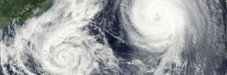
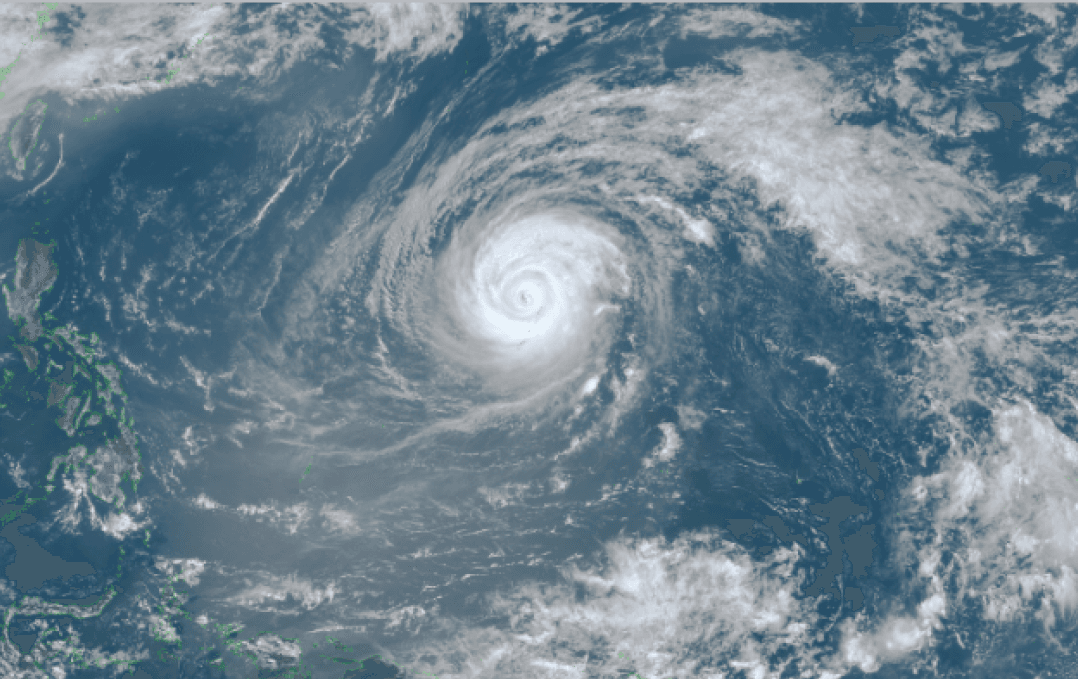
Over the past few days, the maritime community closely monitored Super Typhoon Sinlaku (04W) as it reached its peak intensity. At the height of the storm, satellite imagery painted a striking picture over the Western Pacific, revealing a remarkably distinct, clear eye surrounded by massive, symmetrical cloud bands—the classic visual signature of an extremely powerful and highly organized system.
Himawari Satellite imagery (VIS Color) valid April 13, 2026 06:00UTC
Peak Intensity: 900 hPa and Closing in on the Marianas
Illustrating its immense structural power, Sinlaku's central pressure deepened to an extreme 900 hPa starting around 15:00 UTC on April 12th, persisting at that intense level through 18:00 UTC on April 13th. The storm maintained this absolute peak intensity as it bore down on the Mariana Islands, before showing the first signs of a very gradual weakening late on April 13th, when its central pressure rose slightly to 903 hPa by 21:00 UTC. This slow transition continued into the next day, reaching 908 hPa by 03:00 UTC on April 14th. Despite these minor fluctuations in pressure, Sinlaku maintained its ferocious strength as it passed approximately 74 nm southeast of Saipan, retaining devastating maximum sustained wind speeds of 125 knots—a stark reminder of the prolonged danger posed by such massive systems.
Environmental Drivers and a Grinding Trajectory
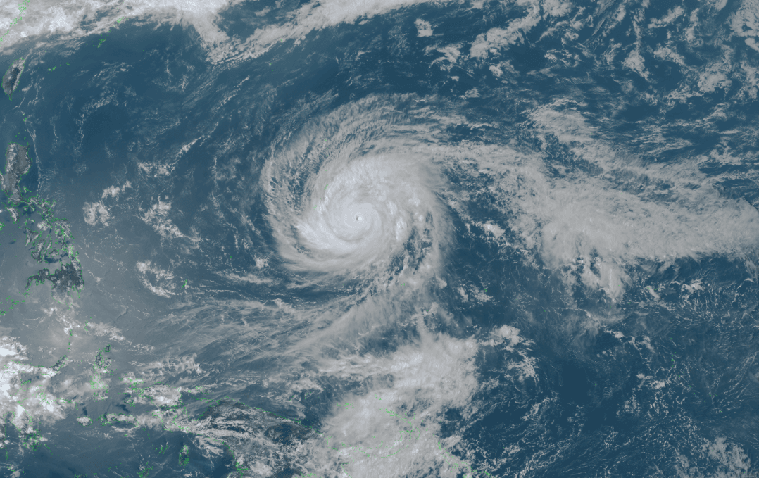
Rather than a rapid collapse following its peak, Sinlaku's behavior has been defined by a slow, grinding transition. Moving sluggishly, the system remains exceptionally powerful as of April 15th, maintaining a central pressure of 930 hPa. Recent satellite imagery confirms the storm has completed its final phase of an eyewall replacement cycle, maintaining a broad, distinct eye.
Himawari Satellite imagery (VIS Color) valid April 15, 2026 03:00UTC
Status as of April 15th
As of the April 15th 00:00 UTC analysis, Sinlaku has weakened to 100 knots while tracking slowly north-northwestward at just 4 knots, situated approximately 42 nm northwest of Saipan. The immediate environment remains characterized by very warm ocean waters, weak vertical wind shear, and high humidity. However, this environment is expected to become overall unfavorable, leading to more sustained weakening after 48 hours. As the system begins to recurve to the northeast after 24 hours, it will begin to encounter cooling ocean waters after 36 hours and increasingly strong vertical wind shear after 60 hours. These shifting factors will dictate a continued weakening trend over the forecast period. The storm is now projected to steadily decline to 50 knots by 120 hours, at which point it will transition into an extratropical system with no significant re-intensification expected during that phase.
Real-World Maritime Response
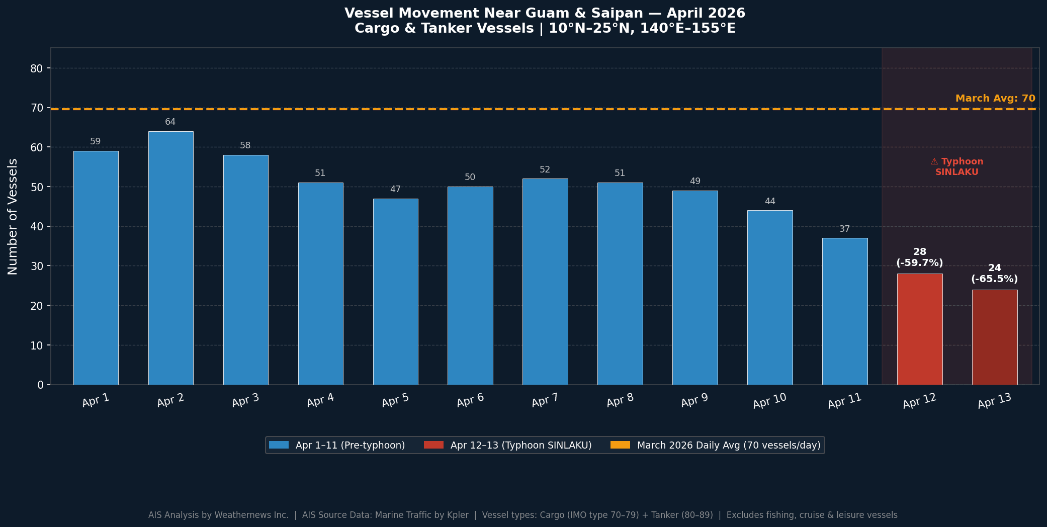
The meteorological situation regarding Typhoon Sinlaku is mirrored by immediate, real-world action from the shipping industry. Weathernews AIS data analysis reveals that during Typhoon Sinlaku's passage near Guam, large commercial vessel traffic in the area dropped by roughly 60–65% compared to the March 2026 daily average of 70 vessels per day.
This decline continued from April 12 to April 13 as the typhoon intensified and moved closer to Guam. The timing of the decline aligns perfectly with the storm's most severe phase: the 900 hPa intensification window directly overlaps with a vessel count drop from 28 to 24 ships in the region. The dramatic overall 60–65% reduction in large commercial vessel traffic near Guam serves as a tangible demonstration of mariners actively executing evasion strategies to avoid the storm's most dangerous sectors.
General Guidelines for Tropical Cyclone Evasion
Sailing in the vicinity of a powerful tropical cyclone requires aggressive risk management. When dealing with systems as massive as Sinlaku, mariners rely on strict operating guidelines to maintain safety:
Clearance Distances: Keep a vessel at least 50 nm away from the 35-knot wind radius, increasing this buffer significantly if heavy swells propagate beyond the wind field.
The Danger of Recurvature: A vessel is advised to avoid passing in front of a recurving tropical cyclone, as these systems can rapidly accelerate during extra-tropical transition, creating a perilous scenario for ships trying to outrun them.
The 1-2-3 Rule: NOAA’s National Hurricane Center recommends a rule of thumb to account for forecast errors by expanding the danger zone by 100 nm at 24 hours, 200 nm at 48 hours, and 300 nm at 72 hours.
Prioritizing Evasion: Maintaining a safe distance takes absolute priority over hitting specific waypoints, requiring constant monitoring until clear by at least 300 nm.
Note on the storm's name: The name "Sinlaku" was contributed by Micronesia and refers to a legendary goddess of Kosrae. Assigning short, distinctive names to tropical cyclones is a practice maintained by the WMO to avoid confusion, streamline warnings, and raise public awareness. In the Western North Pacific, these names are adopted by the ESCAP/WMO Typhoon Committee and used sequentially. To learn more about how storms are named, please visit the World Meteorological Organization (WMO) website.
Rest assured, Weathernews is watching and advising its customers 24/7 with the latest developments of tropical cyclones to ensure their vessels remain safe and well-informed.