It has been roughly two months since the Strait of Hormuz—the vital waterway connecting the Persian Gulf and the Gulf of Oman—was closed in late February 2026. The disruption of this critical global energy chokepoint has triggered massive shifts in international shipping routes.
Regional Shifts and "Polarization" of Traffic
An analysis of AIS (Automatic Identification System) data (AIS Source Data: Marine Traffic by Kpler) from approximately 90,000 vessels conducted by Weathernews confirms a dramatic drop in the number of ships operating around the Strait of Hormuz.
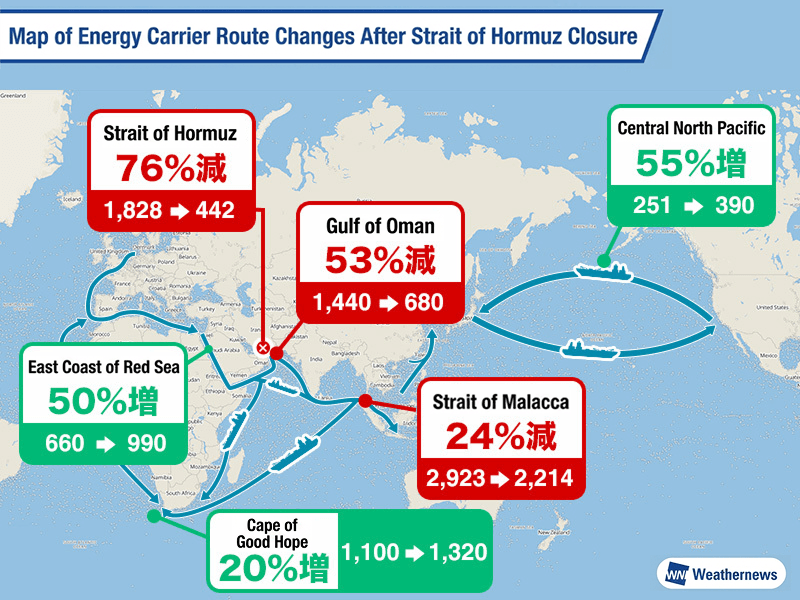
Compared to pre-closure levels, traffic has plummeted by 76% in the Strait of Hormuz (from 1,828 to 442 vessels), 53% in the Gulf of Oman (1,440 to 680 vessels), and 46% in the Persian Gulf (1,380 to 750 vessels). The broader Arabian Sea has also seen an overall traffic decline of 25%.
Conversely, traffic has surged along alternative routes. Vessel numbers have increased by 55% in the North Pacific (near the International Date Line), 50% along the eastern coast of the Red Sea (around Yanbu), and 20% around the Cape of Good Hope at the southern tip of Africa, illustrating a rapid decentralization and realignment of global trade routes.
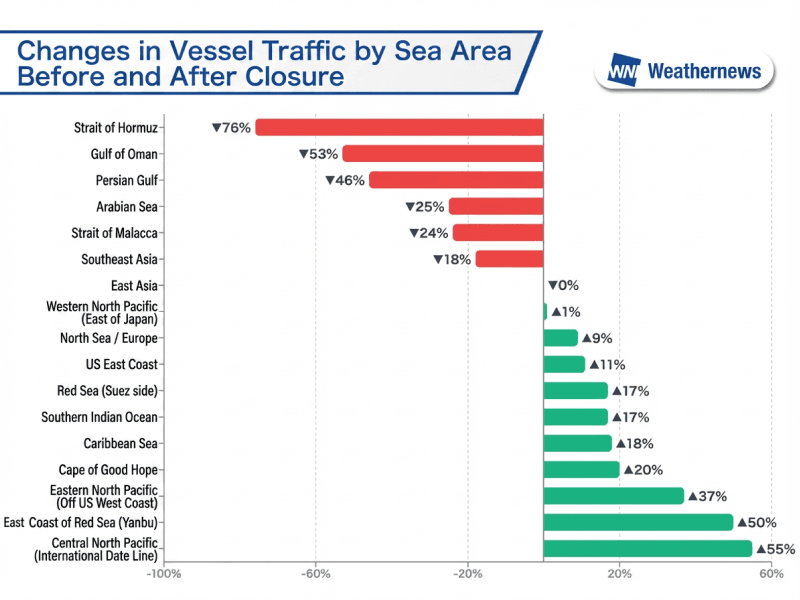
Increased Activity on Alternative Routes
North Pacific: Near the International Date Line, there has been a notable increase in very large gas carriers (VLGCs) and crude oil tankers transiting between Asia and North America.
Red Sea Coast: Around Yanbu, the port's role as a major export hub bypassing the Strait of Hormuz has strengthened, with vessel numbers jumping from 660 to 990.
Cape of Good Hope: The Cape routing has seen a 20% increase in traffic, rising from 1,100 vessels before the closure to 1,320 vessels after. Traffic is up across the entire Cape route, including the southern Indian Ocean, cementing this long-distance detour as a pragmatic alternative.
Rising Costs and Weather Risks Associated with Longer Routes
Routing via the Cape of Good Hope to avoid the Suez Canal and the Strait of Hormuz adds approximately 6,000 to 8,000 nautical miles to the journey between the Middle East and Asia. This inevitably drives up both transport costs and transit times.
Furthermore, the associated weather risks cannot be ignored. As the Southern Hemisphere approaches its winter months (June to August), the waters around the Cape of Good Hope—driven by the westerlies—become prone to gale-force winds, massive waves (often exceeding 8 to 12 meters), and dense fog, making it one of the most treacherous marine environments in the world. The scarcity of safe harbor ports for emergency refuge further elevates the navigational risks.
What to Watch For
While various nations are making moves to secure safety in the Strait of Hormuz, the realignment of shipping routes may become a prolonged reality. Moving forward, the key focus will be on how this "great detour" continues to impact global transport efficiency, maritime safety, and exposure to severe weather risks. Weathernews will continue to provide route assessment insights by incorporating AIS data and meteorological data.