Current Situation
As of June 1st at 15:00 JST, Tropical Storm Jangmi (Typhoon No. 6) was located approximately 90 km south-southwest of Naha, advancing north at an increased speed of 20 km/h. The storm possesses a central pressure of 975 hPa, maximum sustained winds of 30 m/s, and gusts reaching 45 m/s. It is currently maintaining a dangerous storm zone with wind speeds exceeding 25 m/s extending up to 185 km east and 150 km west of its center.
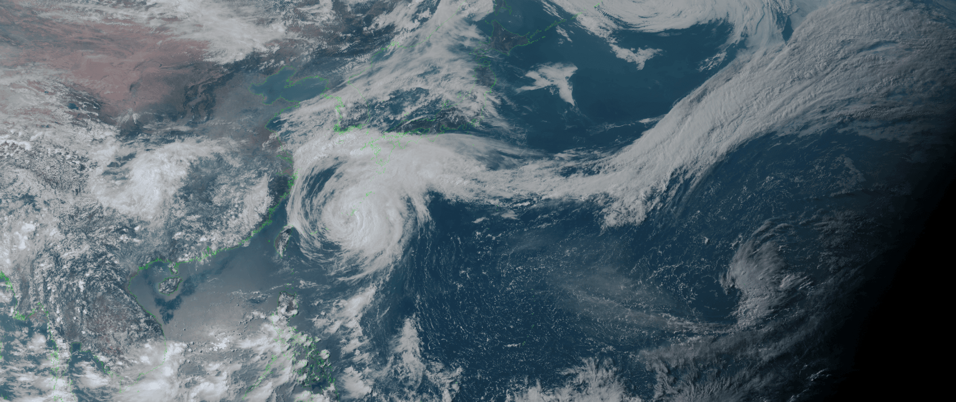
- Himawari Satellite imagery (VIS Color) valid June 1, 2026 06:30UTC
Forecast Track and Front Interaction
The Japan Meteorological Agency (JMA) forecasts that Jangmi will closely approach the Okinawa and Amami regions on June 1st. Following this, the storm will gradually shift its course eastward, tracking along the southern coast of Honshu through June 3rd. The system poses a severe threat as it approaches West and East Japan while maintaining its violent storm zone.
Complicating the situation is a stationary weather front extending from the Nansei Islands to the south of Japan. This front will move north over West Japan by the morning of June 2nd, then travel east along the southern coasts of West and East Japan through June 3rd. The interaction between Jangmi and this front will result in intermittent, extremely heavy rainfall, particularly along the southern to southeastern Pacific slopes.
Regional Hazard Outlook
The JMA has issued severe warnings for winds, waves, and rainfall across the affected regions:
Violent Winds: Maximum gusts of 45 m/s are expected in the Okinawa and Southern Kyushu/Amami regions through June 2nd, expanding to the Shikoku, Kinki, and Kanto-Koshin regions by June 3rd. Winds of this magnitude carry the risk of flying debris and overturning moving trucks.
Towering Waves: Mariners face extreme sea-state hazards. Wave heights, accompanied by heavy swells, are forecast to reach 10 meters in Okinawa on June 1st, 10 meters in Southern Kyushu/Amami on June 2nd, and up to 10 meters in the Kanto-Koshin region by June 3rd.
Heavy Rainfall: Between June 2nd and 3rd, 24-hour rainfall accumulations could reach 400 mm in the Tokai region, and 300 mm in both the Kinki and Shikoku regions.
Key Guidelines for Coastal and Maritime Operators
Based on official JMA guidance, strict precautions are necessary:
Flooding & Landslides: Be on maximum alert for landslides, flooding in low-lying areas, and river overflow in the Nansei Islands through June 2nd, West Japan from June 2nd to 3rd, and East Japan on June 3rd.
Storm Surge: Coastal and estuarine areas must prepare for inundation caused by storm surges.
Severe Squalls: Remain vigilant for violent gusts, lightning, and tornadoes. If signs of a developing cumulonimbus cloud are present, immediately secure safety indoors.
Port-Specific Operational Impacts
As the system accelerates up the Pacific coast, conditions will deteriorate rapidly. To provide a realistic view of the sustained hazards, the following charts represent the expected conditions during the most severe operational windows (caution and warning thresholds) for some of the major ports along the projected path:
Port Forecast Alert Threshold
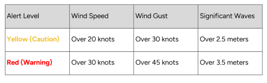
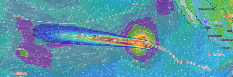
■ Shibushi (Kyushu), Japan
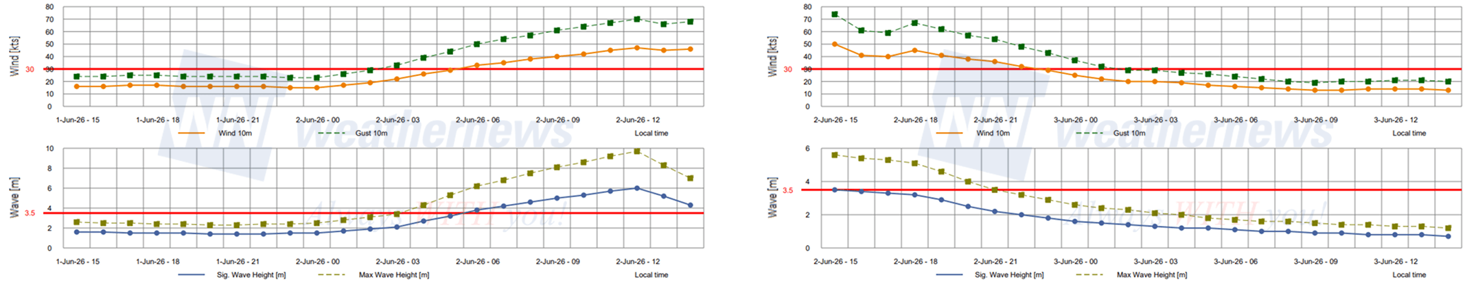
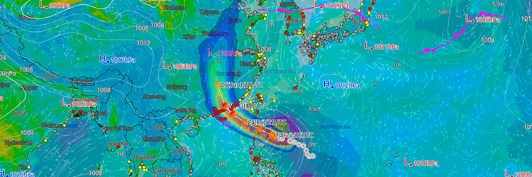
■ Kochi (Shikoku), Japan
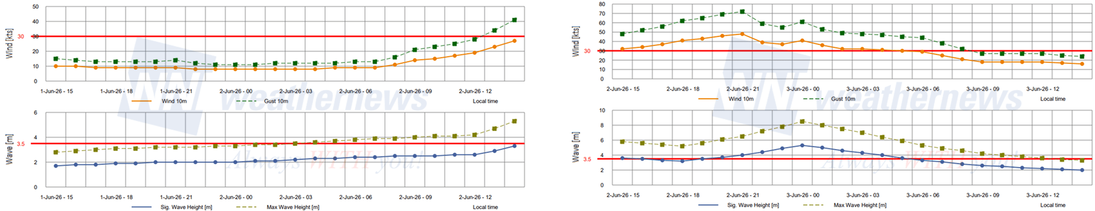
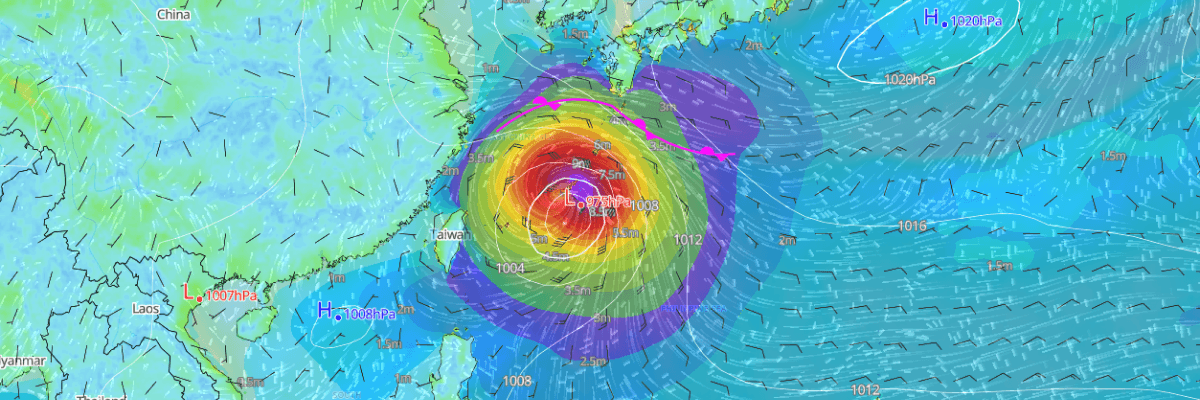
■ Tokyo (Kanto), Japan
Free partial access to Weathernews information is available via our SeaNavigator Free site.
Disclaimer: This outlook is provided for informational purposes only; our actionable, ship-specific advisories are exclusively available through our paid maritime solutions. Weathernews Inc. assumes no liability for navigational decisions, losses, or damages resulting from reliance on this general overview.
While official forecasts guide the general track, highly detailed, proprietary routing and port forecasts are essential for safe navigation. Weathernews services provide customers with 24/7 localized data to ensure your vessels remain safe and well-informed. Please consult our dedicated services for the most up-to-date, detailed predictions for your specific routes and operations.
Note on the storm's name: The name "Jangmi" was contributed by the Republic of Korea (ROK) and translates to "Rose." The WMO and the ESCAP/WMO Typhoon Committee adopt these names sequentially to make tracking specific storms straightforward and to quickly communicate warnings. To learn more about how storms are named, please visit the World Meteorological Organization (WMO) website.