Latest Southern Ocean Latest Southern Ocean Storm Trends: July–September 2026
Storm patterns across the Southern Ocean are shaped by shifting pressure systems that directly influence conditions along critical shipping routes. Over the coming months, these atmospheric changes are expected to bring increased storm activity to the South Pacific, South Atlantic and the waters south of Australia — while easing conditions across the South Indian Ocean and the waters surrounding Australia.
Storm Trend Outlook
Weathernews regularly updates storm trend forecasts to support informed voyage planning. The latest Storm Trend Outlook for July through September 2026 covers key developments across the Southern Ocean, with a focus on the pressure anomalies driving stormy conditions across the region's major maritime corridors.
July 2026
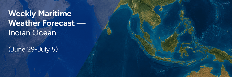
Below-average atmospheric pressure extends across the South Pacific, South Atlantic and the waters south of Australia, creating favorable conditions for storm development. Higher-than-average pressure is expected across the South Indian Ocean and the waters surrounding Australia, reducing the likelihood of severe weather in those areas.
- Fig.1 Monthly sea level pressure anomaly simulation for Jul. 2026 (JMA) ※Yellow indicates higher pressure, and blue indicates lower pressure compared with normal year: (hPa)
Industry Insights: Storm activity is set to increase across the South Pacific Ocean, the South Atlantic Ocean, and the Great Australian Bight, while the South Indian Ocean and Australia's surrounding waters are expected to see calmer, more manageable conditions.
August 2026
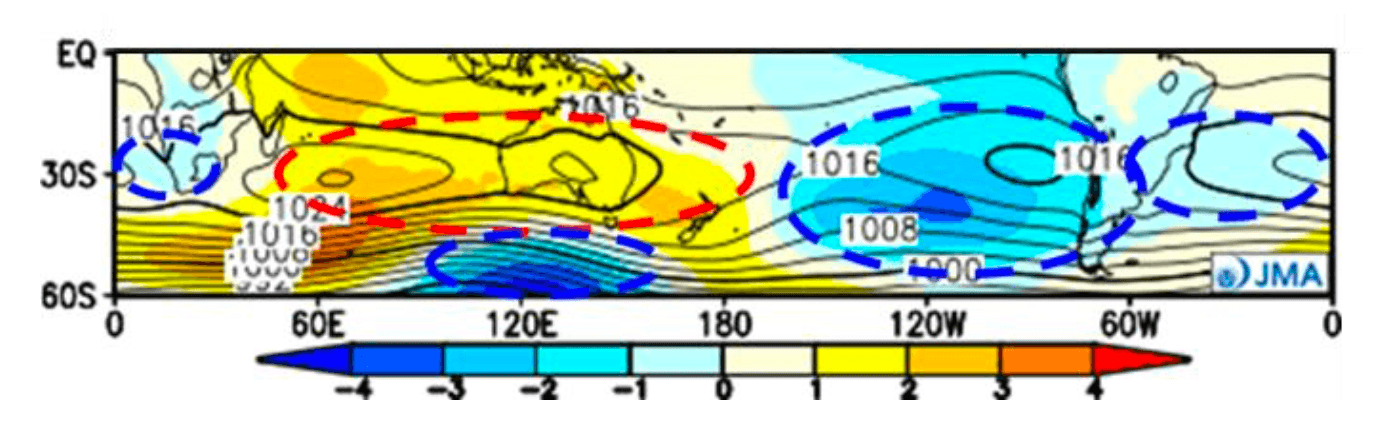
Low-pressure trends persist across the South Pacific, South Atlantic and the waters south of Australia, pointing to a continued likelihood of frequent storm activity. The region from the South Indian Ocean through the waters around Australia continues to experience higher-than-normal pressure, maintaining relatively stable and less disruptive weather.
- Fig.2 Monthly sea level pressure anomaly simulation for Aug. 2026 (JMA)
Industry Insights: Vessels transiting the South Pacific Ocean, the South Atlantic Ocean, and the Great Australian Bight should anticipate challenging conditions, while routes through the South Indian Ocean and Australia's surrounding waters offer comparatively favorable weather.
September 2026
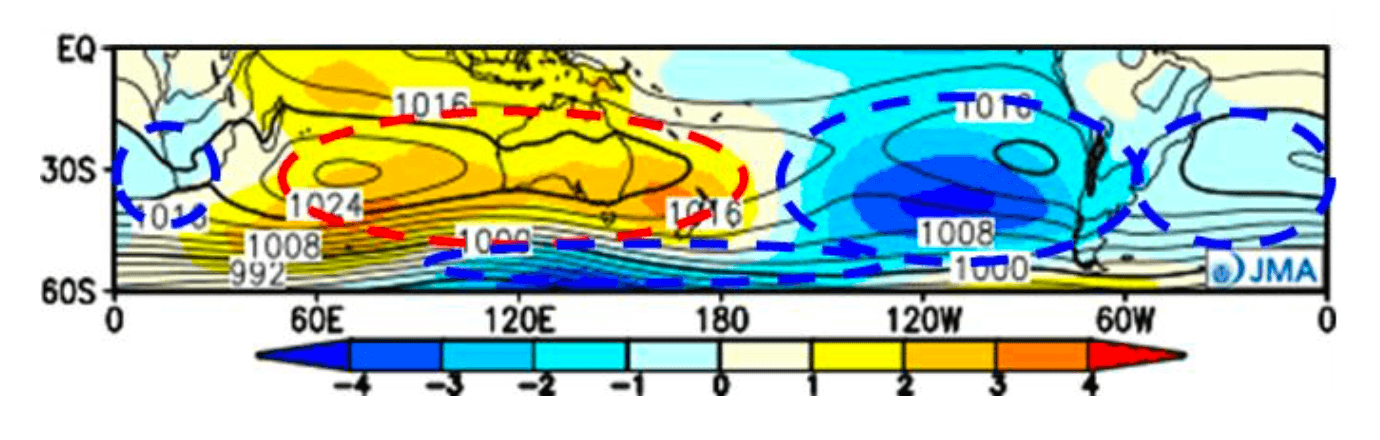
Pressure patterns show little change from August. Rough weather is forecast to occur more frequently than average across the South Pacific, South Atlantic and the waters south of Australia. Conditions ease notably in the South Indian Ocean, the waters around Australia, and — unlike earlier in the season — around Cape Horn, where storm frequency is expected to fall below seasonal norms.
- Fig.3 Monthly sea level pressure anomaly simulation for Sep. 2026 (JMA)
Industry Insights: Consistent stormy conditions continue in the Australia-Tasman Sea corridor and Cape Horn region, while South Atlantic routes offer more favorable conditions for maritime operations.
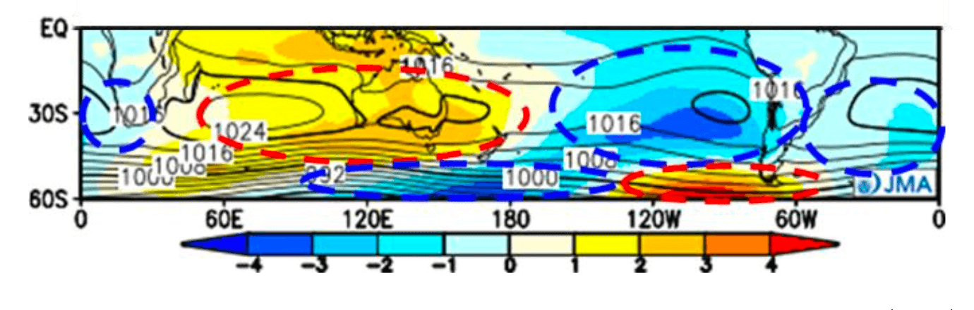
Normal Year Conditions in Southern Ocean
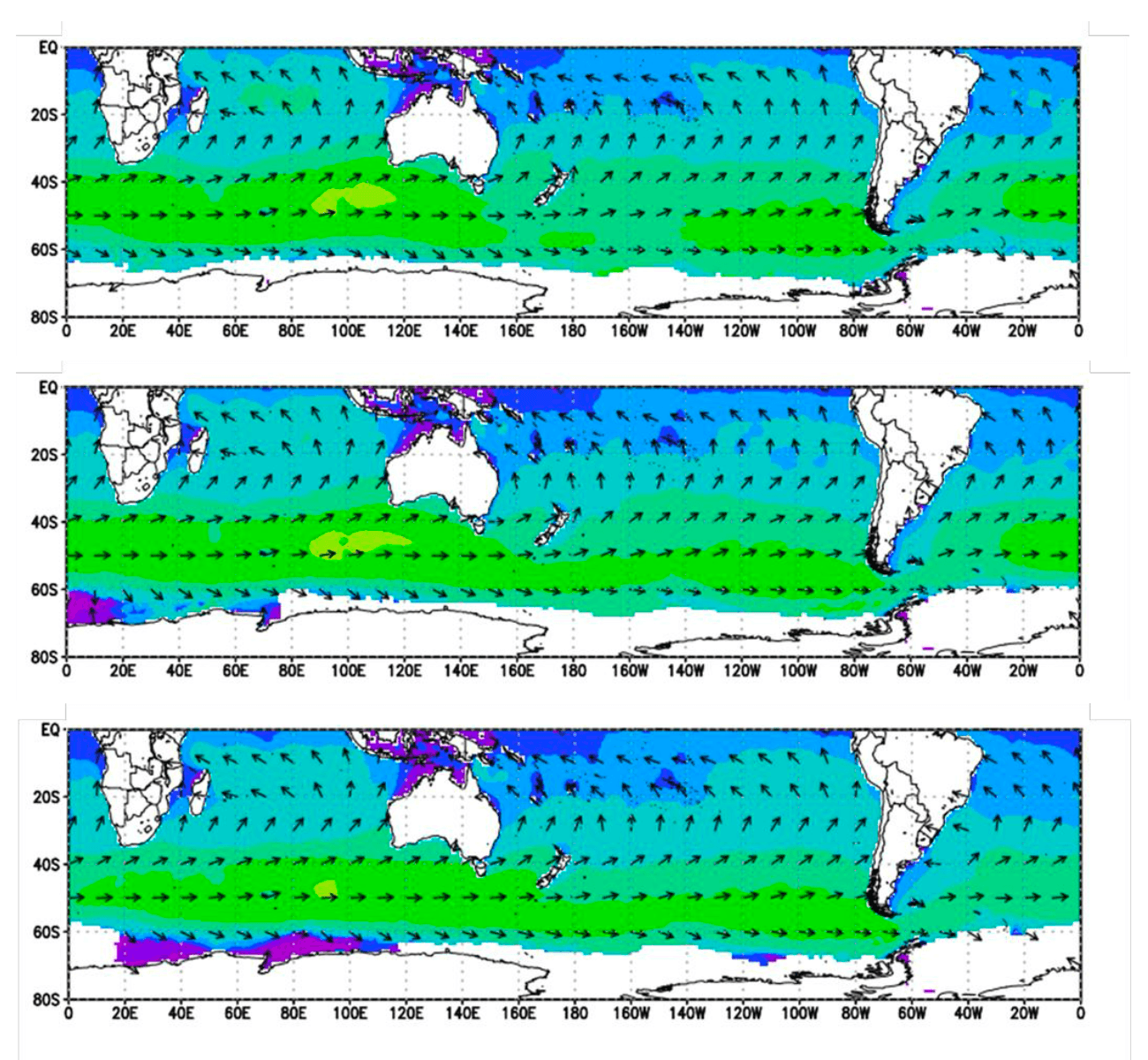
- Fig.4 The mean significant wave height of the past five years (WNI analysis). (Top) July; (Middle) August; (Bottom) September
These baseline conditions help maritime professionals contextualize the forecast period relative to typical Southern Ocean weather patterns during the winter months.
Main Expected Areas of Stormy Conditions:
Stormy conditions are forecast across the same three corridors throughout July and August:
- The South Pacific Ocean
- The South Atlantic Ocean
- The Great Australian Bight (waters south of Australia)
By September, the pattern holds across these corridors — however, Cape Horn stands out as an exception, with rough weather expected to ease below seasonal norms for vessels transiting the passage.
Maritime operators should plan accordingly for these regional variations when scheduling voyages through Southern Ocean routes during the July–September 2026 period.