The Signal Dropped. Then the Picture Got Complicated.
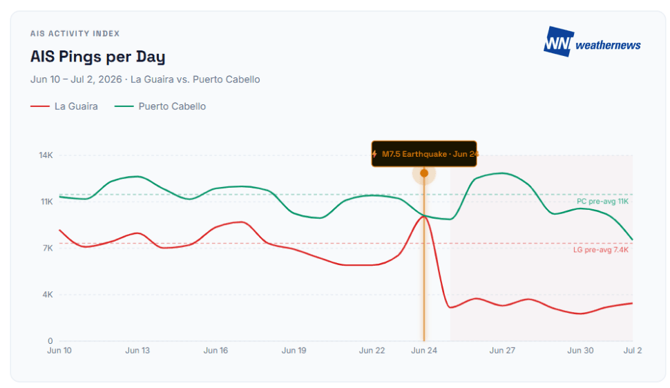
When two powerful earthquakes struck northern Venezuela on the evening of June 24, the tremors were felt far beyond the coastline. Within 24 hours, vessel tracking data told an immediate story: AIS activity at the Port of La Guaira fell by 64% the day after the earthquake. At Puerto Cabello, Venezuela's largest commercial port located roughly 180 kilometers to the west, activity barely moved — down just 4%, virtually unchanged.
Two weeks of continuous AIS monitoring by Weathernews (between June 24 to July 2, 2026) has confirmed what those early signals suggested: Venezuela is operating with one port absorbing diverted cargo, one port repurposed as a humanitarian hub, and a significant information gap where official maritime communications would normally be.
Two Ports, Two Very Different Stories
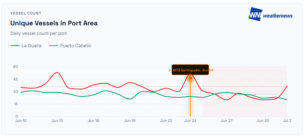
Weathernews tracked AIS pings per day and unique vessel counts at both ports from June 10 through July 2, 2026 (AIS data source: MarineTraffic by Kpler).
La Guaira
At La Guaira, pre-earthquake activity averaged approximately 7,400 AIS pings and around 35 unique vessels per day. Following June 24, activity fell sharply, reaching a low point of just 20 daily vessels between June 27 and 30. The numbers reflect what was happening on the ground: early assessments from shipping agents on June 25 had suggested the port was undamaged and operational, but those assessments did not hold. By June 29, La Guaira had been declared inoperative for commercial operations, with significant structural damage confirmed across warehouses and container handling facilities.
A specialized team of U.S. Marines worked around the clock to carry out repairs sufficient for the USS Fort Lauderdale to berth — the amphibious transport dock now serving as a floating communications center, medical platform, and aid distribution hub. For commercial shipping, the port remains closed until approximately July 15 pending structural assessments, with both Maersk and MSC suspending bookings until further notice. As of July 2, AIS activity shows modest partial recovery but remains well below pre-earthquake levels. The contrast is clear: La Guaira's maritime signal significantly decreased and has yet to recover to normal levels.
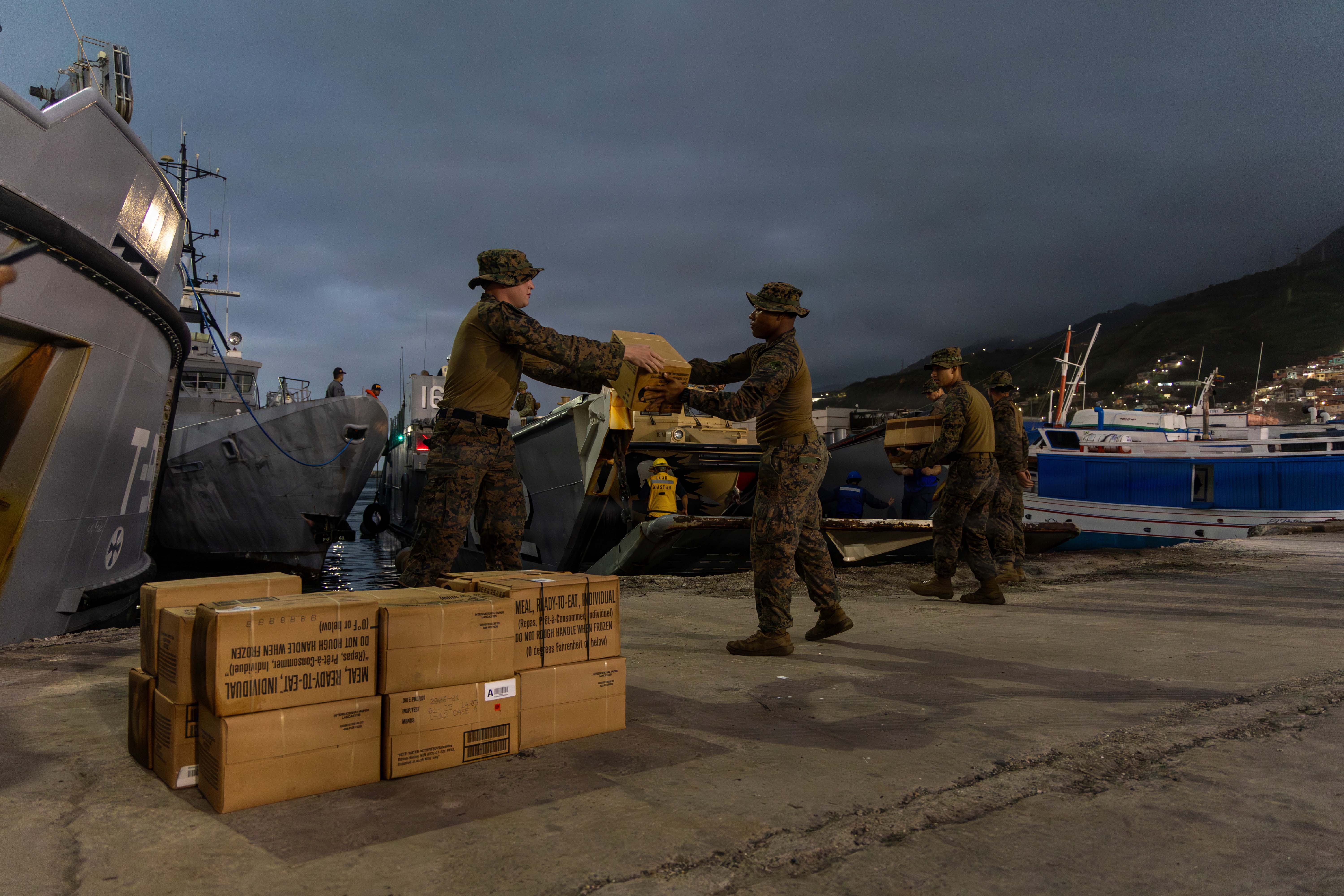
Marines and sailors offload disaster-relief supplies at La Guaira Port, Venezuela, June 27, 2026. Photo by Marine Corps Sgt. Daniel Childs, U.S. Department of War (VIRIN: 260627-M-TH104-3228). Source: https://www.war.gov/News/News-Stories/Article/Article/4531605/us-military-supports-venezuela-earthquake-response/
Puerto Cabello
At Puerto Cabello, pre-earthquake AIS activity averaged around 11,000 pings per day — already a significantly busier port. Post-earthquake, the port absorbed diverted traffic and maintained broadly stable vessel counts throughout the monitoring period. For cargo originally destined for La Guaira, Puerto Cabello is now the primary rerouting point and the recommended entry for sea freight, according to freight forwarders including Kuehne+Nagel. Under normal conditions the port already handles close to 30% of Venezuela's maritime imports, making it the natural fallback for diverted shipments. Moderate congestion and longer dwell times are expected as authorities balance commercial cargo against humanitarian shipments, while road access to Caracas and La Guaira — though gradually improving — continues to add friction to inland delivery.
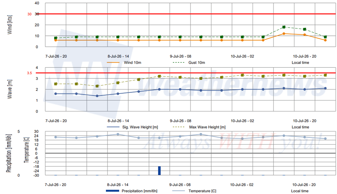
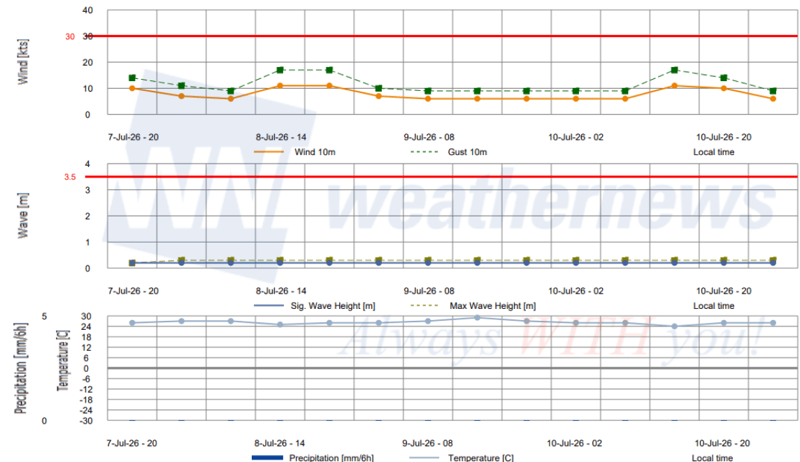
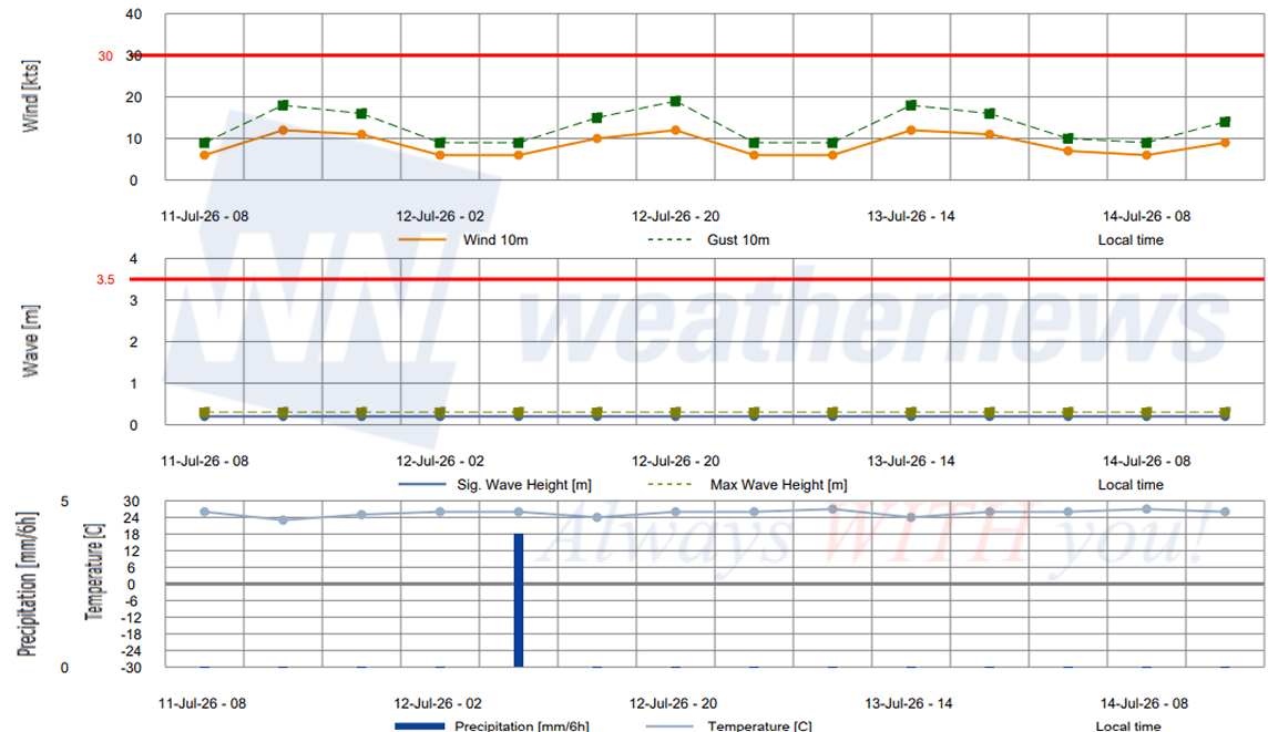
Port Forecasts for La Guaira and Puerto Cabello
■LA GUAIRA, Venezuela
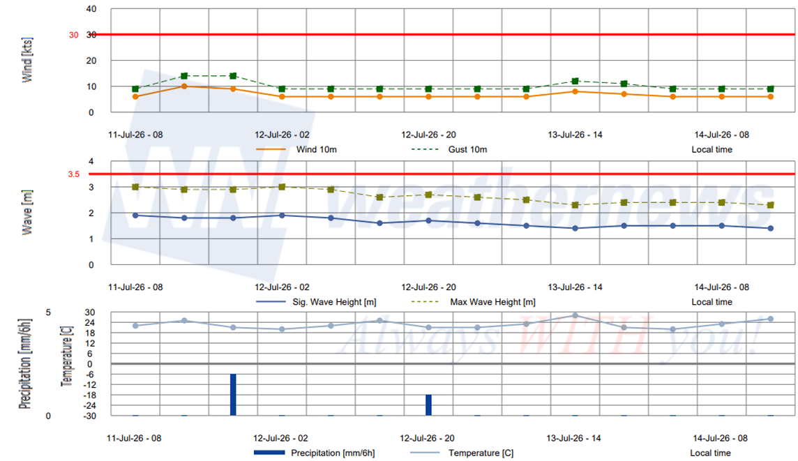
■PUERTO CABELLO, Venezuela
What to Watch
The situation at Venezuela's ports remains fluid. Key indicators to monitor in the coming days include:
- La Guaira's July 15 commercial reopening target — dependent on the outcome of structural safety assessments still underway
- Puerto Cabello congestion levels — as the sole commercial gateway, its ability to absorb continued pressure without significant operational degradation will be critical
- Ongoing aftershock risk — more than 30 have been recorded, and seismic activity in the region has not fully stabilized
- Weather conditions — post-earthquake rainfall risk adds further uncertainty to infrastructure recovery timelines
What We Know — and Why It's Limited
On the evening of June 24, a magnitude 7.2 earthquake struck near Morón in Carabobo State, followed less than a minute later by a stronger magnitude 7.5 — a doublet earthquake that the United States Geological Survey (USGS) noted was the most powerful in the area since 1900, surpassing even the destructive 1967 Caracas earthquake. The quakes triggered widespread building collapses across Caracas and La Guaira State, closed Simón Bolívar International Airport, and prompted a brief tsunami advisory for nearby Caribbean coastlines. The death toll, which stood at 164 in the immediate aftermath, has since climbed to over 3,500, with satellite data estimating over 50,000 buildings damaged or destroyed — far exceeding official reported counts.
For maritime professionals, piecing together an accurate operational picture has been a challenge throughout. Venezuela's port pages remain inaccessible, no NAVTEX warnings have been issued through standard channels, and there has been no port authority communication of the kind that would normally accompany a disruption of this scale. With the Venezuelan government still focused on managing the immediate humanitarian crisis, routine maritime communications have taken a back seat. In this environment, AIS monitoring and external reporting have become the primary tools for tracking what is actually happening at Venezuela's ports.
Disclaimer: The banner image is a stock photograph used for illustrative purposes and is not associated with or taken at the event described in this article.