The Strait of Hormuz remains under heightened geopolitical tension. Security incidents continue to accumulate along the Gulf of Oman corridor—including vessels reported adrift, vessels on fire, and a confirmed mine near the Strait itself. Most of the maritime industry's attention has centered on a single question: when will conditions allow ships to leave?
That focus is understandable—since getting vessels out is an urgent priority, but even when the geopolitical window opens, another challenge may already be waiting beyond the Strait. This one does not depend on politics, and it arrives on a predictable seasonal schedule.
Waiting for the Opportunity to Leave
As of August 6, 2026, AIS data shows 6,844 vessels tracked across the Persian Gulf—an 11.5% rise from 6,137 one week earlier, of which 1,087 are at anchor and a further 1,091 are moored, placing roughly one-third of all traffic in a stationary state.
The concentration is highest near the Strait of Hormuz. In the Gulf of Oman approach zone— a narrower corridor covering the Strait exit, 1,155 vessels are tracked in total, of which 55% are anchored or moored. At the Fujairah OPL anchorage alone, more than 170 vessels have gathered, some with "FOR ORDER" listed as their destination, meaning no port has yet been assigned.
When departures eventually resume, leaving the Gulf will only mark the beginning of the next operational challenge. The southwest monsoon is now well established across the Arabian Sea, meaning many of these vessels will sail directly into deteriorating weather conditions. The impact of those conditions varies significantly depending on vessel type and cargo.
Beyond vessel count, the chart below shows what the anchored fleet is carrying — and what each type faces once underway in monsoon conditions.
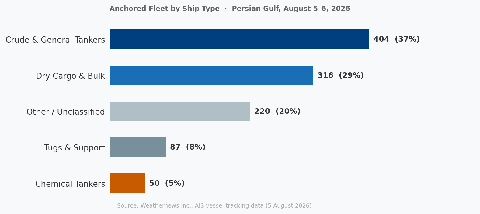
AIS source data from MarineTraffic by Kpler, analyzed by Weathernews
Different vessel types face different operational challenges under the southwest monsoon. Crude oil tankers face sloshing loads in partially filled tanks and structural stress from sustained beam swell. LNG (liquefied natural gas) carriers require closer temperature monitoring as Arabian Sea surface temperatures peak at 28–30°C in August, it would accelerate cargo boil-off, placing additional pressure on reliquefaction systems for the duration of the voyage.
Departures remain contingent on the security situation—circumstances outside operators' direct control. However, when that window finally opens, the focus shifts. The question moves from whether vessels can leave to whether the voyage ahead can be safely completed.
The Southwest Monsoon
The southwest monsoon reaches its intensity peak in July and August—winds at their strongest, convective activity at its most widespread, and swell heights at their highest. The system will not begin its seasonal withdrawal until late September. The conditions vessels face today are not the beginning of this pattern. They are in the middle of it.
AIS data from the open Arabian Sea as of August 5 shows departing traffic in near-perfect balance: 206 vessels heading westbound, toward the Gulf of Aden, Red Sea, or around the Cape of Good Hope and 206 heading eastbound, toward India and the Bay of Bengal. Both directions transit into active monsoon conditions from the moment they clear the Gulf of Oman.
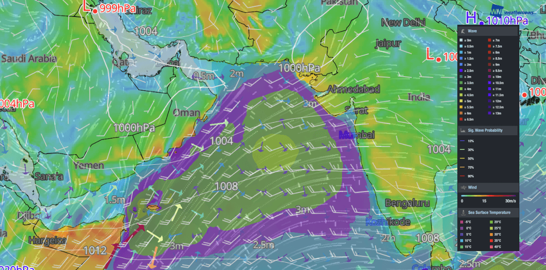
SeaNavigator Image valid August 6, 2026 07:00 UTC
Westbound: Against the Monsoon
Vessels departing the Persian Gulf on a westbound heading, toward the Gulf of Aden, Red Sea, or Suez Canal travel directly against the southwest monsoon flow. Wind and swell meet them head-on from the moment they clear the Gulf of Oman. The forecast for August 6 shows sustained winds of 23–24 knots at the Gulf of Oman exit, with the Somali Jet—the monsoon's primary wind corridor already reaching 27–28 knots through August 6–8, as the previously forecast peak materialises. Significant wave heights in the northwestern Arabian Sea remain at 3.5–5.5 metres, with swell propagating progressively along India-bound routes.
Sustained beam swell exposure increases structural load and extends voyage times. For laden crude oil tankers and LNG carriers, sustained beam swell exposure places structural stress on hulls and partially filled tanks, while elevated sea temperatures accelerate boil-off rates in LNG cargo—compounding the voyage cost on every day at sea.
Eastbound: With the Monsoon
Vessels departing on an eastbound heading toward India’s west coast, Sri Lanka, or the Bay of Bengal, travel in broadly the same direction as the monsoon flow, carrying downwind rather than fighting against it. The southwest wind on the port quarter or stern reduces hull resistance, lowering fuel consumption and supporting faster transit compared to a westbound run through the same conditions. However, running with the monsoon introduces its own risks. Following seas of 3.5–5.5 metres increase rolling, particularly for LNG carriers. Combined with Arabian Sea surface temperatures—which already elevate boil-off rates, the additional vessel motion can further increase cargo losses throughout the voyage regardless of whether the vessel is sailing with or against the prevailing winds.
Furthermore, since the Somali Jet corridor sits south of the direct Gulf-to-India track, eastbound vessels do not transit its most intense axis, but the swell it generates propagates northeast across the Arabian Sea regardless of where the vessel is heading. An eastbound vessel still encounters three to four days of monsoon-generated swell, the challenge simply arrives from a different angle.
Turning Data into Decisions
Much of the discussion around the Strait of Hormuz has focused on the first barrier—geopolitical risk. Yet even if departures resume in July-September, vessels will soon encounter a second barrier which is the southwest monsoon already developing across the route ahead.
Understanding that challenge requires more than tracking vessel positions or monitoring weather forecasts independently. AIS data does more than confirm a vessel’s current position, it enables a vulnerability assessment. Each vessel continuously broadcasts its position, heading, speed, vessel type, and reported draft. Cross-referencing those data points against a route-level weather forecast grid makes it possible to identify which anchored vessels sit in zones where conditions are forecast to deteriorate, and which underway vessels are on tracks that will intersect with the worst sea states, and when. This provides a more complete operational picture, supporting better-informed planning as geopolitical conditions and weather continue to evolve.
For maritime professionals who want to view vessel movements alongside current and forecast weather conditions, Weathernews is publicly disclosing port forecasts for the Middle East via our platform SeaNavigator Free for a limited time.