[Updated] 2025 Tropical Storm & Hurricane Outlook: Mid-Season Recap and Analysis
Weathernews' June seasonal outlook anticipated an active early season for the North Atlantic and quieter conditions for the Northeast Pacific. Mid-season observations reveal the opposite pattern has emerged, with the Northeast Pacific experiencing robust early activity while the North Atlantic has seen a slower-than-average start. However, late-season forecasts remain consistent with our initial projections, with both regions expected to finish near or slightly above seasonal averages.
1. Northeast Pacific Recap & Outlook
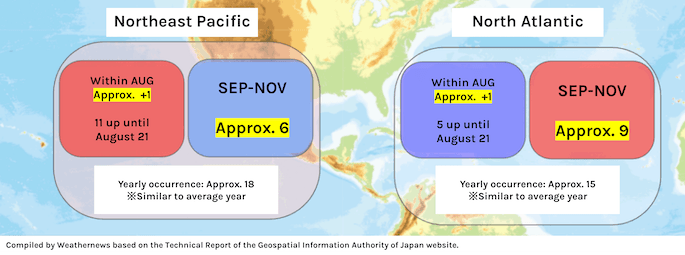
The Northeast Pacific has experienced an active start, with eleven tropical storms/hurricanes developing through August 21, with an additional tropical storm or hurricane expected within August. This is above the seasonal average of 5.9 systems for this period. However, September through November activity is forecast to be below the historical average of 10.5 systems, with approximately 6 additional tropical storms or hurricanes expected.
In total, around 18 tropical storms or hurricanes are projected for the complete season, representing slightly above-average activity.

2. North Atlantic Recap & Outlook
In the North Atlantic, 5 tropical storms/hurricanes have developed as of August 21, with an additional 1 expected within August. This is a slower pace than the 1851-2018 average of 9.6 systems. However, activity in the latter half of the season (September to November) is expected to be slightly higher than the seasonal average of 5.4, with approximately 9 additional tropical storms or hurricanes forecast.
This brings the seasonal total to approximately 15 tropical storms or hurricanes, placing the season in the near-average category.

Atmospheric & Oceanic Conditions Behind the Forecast
Late Season (September–November)
Convective activity over the Bay of Bengal is expected to increase more than usual. This causes the zone of rising air to shift westward compared to the early season. As a result, the descending air over the Northeast Pacific also shifts westward, allowing convective activity to return to near-normal levels. Vertical wind shear is expected to ease slightly compared to earlier in the season, making conditions moderately more favorable for storm formation.
Meanwhile, the North Atlantic continues to show slightly weaker-than-usual convective activity. However, vertical shear remains lower than normal, so conditions stay conducive for tropical storms and hurricanes to occur slightly more often than average.

Reference Years and Historical Patterns
This year’s atmospheric environment closely resembles the seasons of 2021, 2017, 2013 (WNI statistics), 2008, 1995 (NOAA statistics), based on similarities in sea surface temperature anomalies and atmospheric circulation patterns across the El Niño monitoring region, the North Atlantic and the Northeast Pacific regions.
1. Northeast Pacific
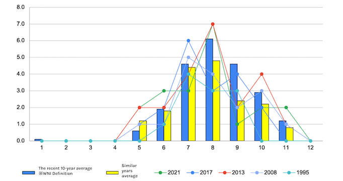
- The number of occurrences over the past 10 years has been 22.0, which is about 6 more than average.
2. North Atlantic
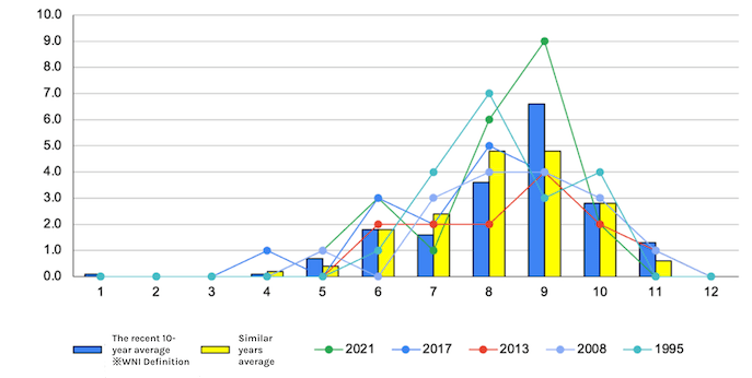
- The number of occurrences over the past 10 years has been 18.6, which is about 4 more than average.
Storm Tracks and Development Regions
No significant deviations from recent 10-year patterns are expected in terms of storm development locations or track trends in either the North Atlantic or Northeast Pacific basins.
1. Northeast Pacific

- Track maps of tropical storms/hurricanes that occurred in similar years (2021, 2017, 2013, 2008, 1995) (left) and track maps of tropical storms/hurricanes that occurred in the last 10 years (2015-2024) (right) (Source: NOAA)
2. North Atlantic
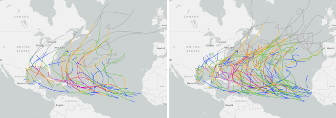
- Track maps of tropical storms/hurricanes that occurred in similar years (2021, 2017, 2013, 2008, 1995) (left) and track maps of tropical storms/hurricanes that occurred in the last 10 years (2015-2024) (right) (Source: NOAA)
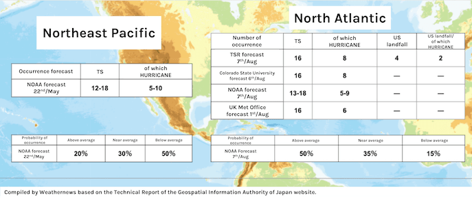
Forecasts from Each Organization
