Many vessels remain stranded in the Strait of Hormuz amid the ongoing tense situation.
While there have been reports announcing the resumption of navigation through the Strait of Hormuz, the UK maritime intelligence Lloyd’s List noted on April 7 that the payment of transit fees could place shipowners in a legal gray zone. In other words, many challenges still remain before vessels can safely resume transit.
Weathernews has previously reported on the potential impact of "Shamal" (a northwesterly wind typical of this season) and squalls on safe navigation in the Persian Gulf. To account for ships stranded in the gulf, we analyzed Automatic Identification System (AIS) positional data of vessels.
AIS and Weather Insights: A Fleet at Anchor
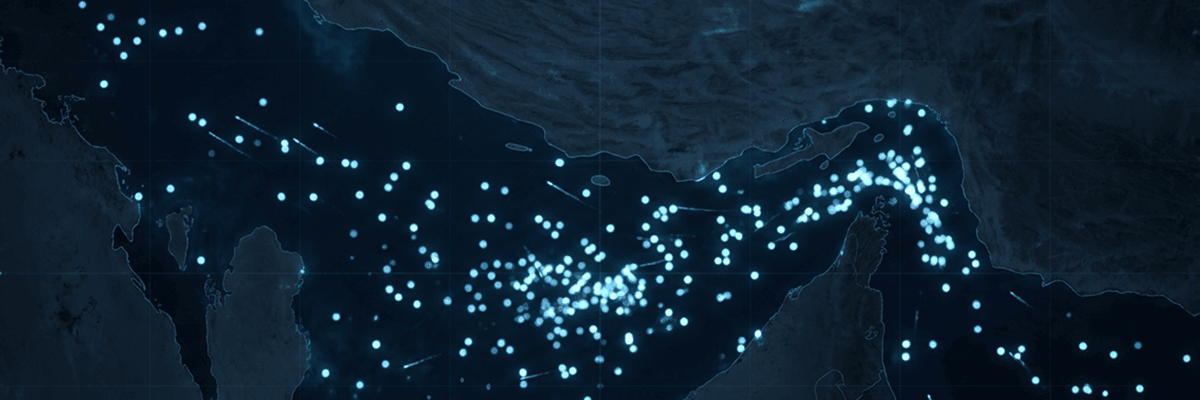
As of April 7, over 600 large vessels (of 10,000 tons+ deadweight tonnage [DWT]), typically utilized for transporting ocean-going cargo, have been confirmed within the Persian Gulf. The region is entering a season where winds can occasionally exceed 30 knots. Remaining in the same position elevates the risk of grounding or colliding with quays and other vessels.
By monitoring temporal changes in AIS positional data, we found that vessels are exhibiting movements consistent with "swinging on anchor", shifting in response to daily tides and wind directions.

AIS Analysis by Weathernews Inc.; AIS Source Data: Marine Traffic by Kpler
This behavior is primarily evidenced by fluctuations in heading. Among the large vessels stranded in the Persian Gulf between April 1 and April 8, 2026, navigating at speeds of 3 knots or less, we investigated the movements of 15 vessels that recorded the highest total absolute values for heading changes of 30° or more.
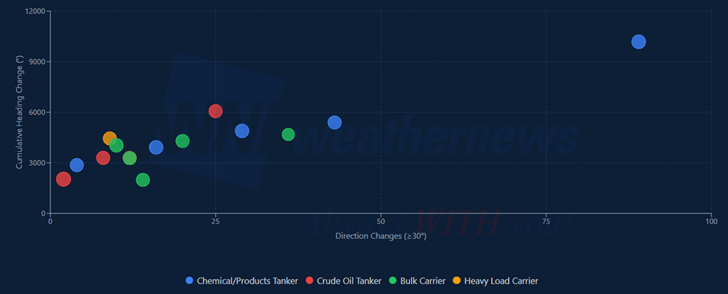
AIS Analysis by Weathernews Inc.; AIS Source Data: Marine Traffic by Kpler
Many of these 15 vessels changed their headings dozens of times over the course of a week, with a cumulative angle of approximately 5,000°, which is equivalent to about 14 full rotations in one week.
While these heading changes occur naturally as a vessel swings with the wind and tide, more complex meteorological and sea conditions, such as waves and swells, often necessitate active maneuvering to maintain safety. With prolonged delays requiring the securing of food and water for the crew, such maneuvers are sometimes necessary to ensure the safety of the vessel, the cargo, and, above all, the estimated 20,000 seafarers who remain stranded.
Available Forecasts on SeaNavigator Free
Driven by our commitment to maritime safety, Weathernews is providing these general weather trends as a reference for the public and stakeholders navigating this complex situation.
For a limited time, we are publicly disclosing port forecasts for the Middle East via our platform SeaNavigator Free. We monitor 150 locations across the region and its surrounding waters, updating four times daily with 48-hour, 5-day, and 7-day outlooks.
View Full Port List & Detailed Forecasts on SeaNavigator Free
Major Ports with Published Port Forecasts
Persian Gulf Region
- United Arab Emirates: Abu Dhabi Port, Dubai Port, Fujairah Port, Khor Fakkan Port, Mubarak Terminal, Fateh Terminal
- Iran: Bandar Abbas Port, Larak Island
- Qatar: Doha Port, Ras Laffan Port
- Bahrain: Bahrain Port, Sitra Port
- Saudi Arabia: Ras Tanura Port, Jubail Port
- Kuwait: Kuwait Port
- Iraq: Al Basrah Oil Terminal
Approximately 150 locations are covered, including ports in the Red Sea and the west coast of India.