


The protracted 2025–2026 weak La Niña event is officially ending, signaling a major global climate transition. March-April 2026 updates from leading meteorological agencies show the tropical Pacific rapidly shifting to an ENSO-neutral state, which has a 60% chance of lasting through May. However, forecasts warn of a growing 60% likelihood that El Niño will develop by the Northern Hemisphere summer.
Further reading on El Niño climate impacts: see National Oceanic and Atmospheric Administration (NOAA)
Understanding the ENSO Cycle: El Niño vs. La Niña
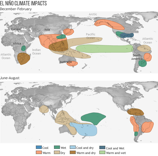
To understand the gravity of these forecasts, it helps to understand the underlying mechanics of the El Niño-Southern Oscillation (ENSO) cycle. According to the World Meteorological Organization (WMO), ENSO is the dominant feature of global climate variability on year-to-year timescales. Normal Pacific conditions involve trade winds blowing west, pushing warm surface water toward Asia. El Niño and La Niña are opposing climate phases that disrupt this norm.
During an El Niño, these trade winds weaken. As a result, the westward push of surface water is reduced, causing the pool of warm equatorial water to be positioned further east across the central and eastern Pacific than usual. This shift alters global jet streams and generally increases average global surface temperatures. Conversely, La Niña amplifies normal conditions: trade winds grow unusually strong, pushing warm water further west and causing colder, deep-ocean water to rise in the eastern Pacific, which typically has a cooling tendency globally. Both extremes heavily dictate global temperatures, rainfall patterns, and the intensity of extreme weather events.
Weathernews Spring and Summer 2026 Outlook
Unpacking the "Super El Niño" Forecast
While headlines across major news outlets are currently buzzing with predictions of a historically strong "super El Niño," the latest scientific updates indicate that these warnings are grounded in a rapidly escalating reality. To put the forecasts in perspective, the National Oceanic and Atmospheric Administration (NOAA) categorizes El Niño strength based on Oceanic Niño Index (ONI) thresholds. Recently, NOAA introduced a “Relative ONI” (RONI) metric to filter out broader global warming trends and more accurately identify these climate events. Because this new relative index is scaled to match traditional amplitudes, the historical thresholds remain perfectly applicable for users: weak (0.5°C to 0.9°C sea surface temperature anomaly), moderate (1.0°C to 1.4°C), strong (1.5°C to 1.9°C), and very strong (2.0°C and above).
Crucially, for an event to officially reach a specific category, the three-month average anomaly must be sustained for at least three consecutive overlapping seasons. To put this into context, the widely discussed 2023 El Niño briefly spiked above the 2.0°C mark, but because it only sustained that peak for two overlapping seasons, it officially remained a "strong" event. For 2026, however, IRI models forecast anomalies reaching +2.0°C by year-end, and NOAA gives a 25% probability of a sustained "very strong" event—a phenomenon recorded only three times since 1950.
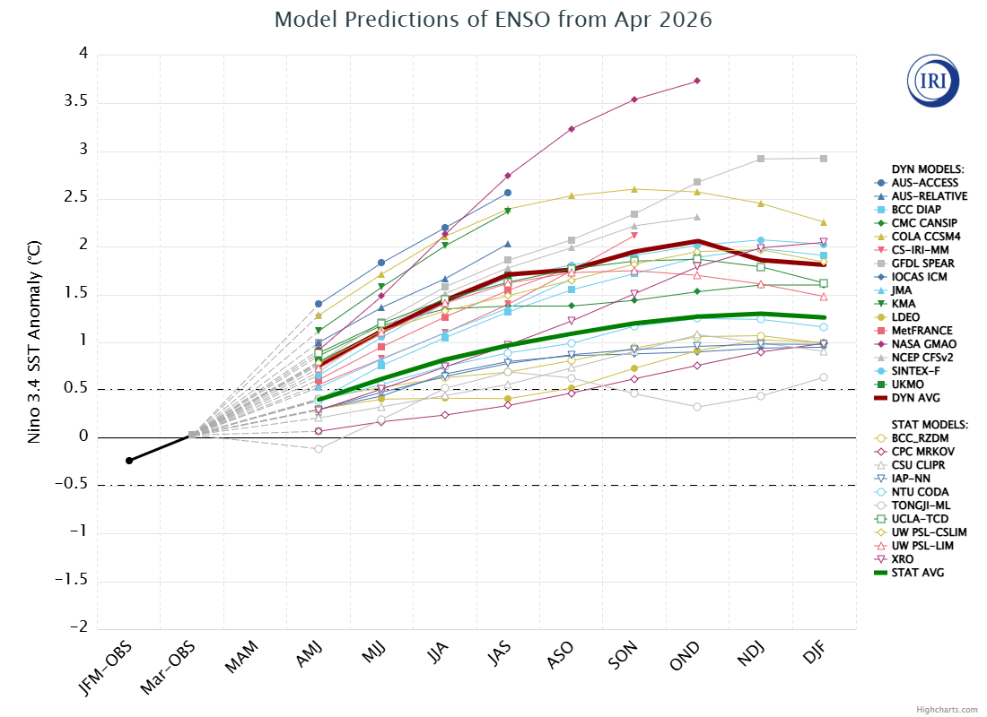
IRI’s April 2026 model predictions for Niño 3.4 SST anomalies; source: International Research Institute for Climate and Society (IRI), Columbia University.
Beyond peak intensity, what most concerns Weathernews meteorologists is the extreme rarity of this broader climate cycle. Bouncing from a significant El Niño, to a brief La Niña, and straight into a potential "very strong" El Niño within a single year is a pattern that has not occurred since 1963–1965. With mid-latitude sea surface temperatures already mirroring 2023's extreme anomalies, historical playbooks may fall short, demanding urgent preparations for unprecedented localized weather and disrupted routing patterns.
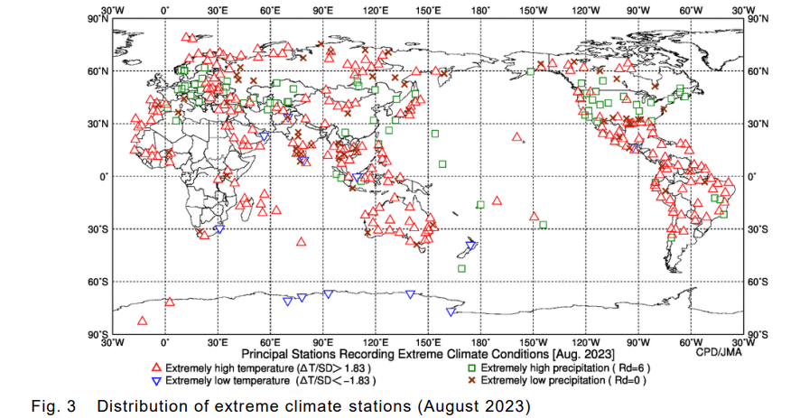
Distribution of extreme climate stations (August 2023); source: Japan Meteorological Agency (JMA)
Implications for Maritime Weather Routing (2026 Outlook)
If the forecasted strong El Niño materializes as expected, this impending climate transition poses significant potential risks for voyage optimization and marine weather routing throughout the upcoming seasons:
Wind and Current Optimization (April–July 2026)
As the Pacific settles into an ENSO-neutral state during the Northern Hemisphere spring and early summer, the currently strong equatorial trade winds are expected to weaken and shift. Weather routing teams will need to actively adjust trans-Pacific shipway routes during this transitional window to minimize headwind resistance, thereby optimizing fuel consumption and cutting greenhouse gas emissions.
Dynamic Cyclone Avoidance (2026 Typhoon Season)
Drawing on tropical cyclone patterns from the analogous 2023 strong El Niño year, maritime operators should prepare for a distinct geographical shift in storm development. During El Niño phases, Pacific cyclogenesis typically shifts to the east or southeast of its normal historical range. Because these storms originate further out in the open ocean, they spend a significantly longer amount of time traveling over warm sea surface temperatures. This prolonged exposure allows them to absorb massive amounts of water vapor energy as they move north, resulting in a higher frequency of exceptionally strong typhoons.
Furthermore, typical storm tracks change; data indicates fewer typhoons heading toward the East China Sea and an increased tendency for storms to approach the Pacific coast of eastern Japan. Weather routing algorithms must continuously adapt to these changeable tracks. Operators must employ strict evasion protocols: maintaining a baseline 50-nautical-mile clearance from the 35-knot wind radius, applying NOAA's 1-2-3 Rule to expand the danger zone up to 300 nautical miles for 72-hour forecasts, and strictly avoiding passing in front of a rapidly accelerating, recurving cyclones.
To provide operators with a more granular forecast of these shifting tracks, Weathernews will be publishing its dedicated 2026 Tropical Cyclone Outlook in the coming weeks, expected around May or early June.
Strategic Rerouting & The Panama Canal Bottleneck (Mid-to-Late 2026)
With IRI models now indicating an 88–94% probability of El Niño dominating the latter half of 2026, long-range predictability is critical. While El Niño is traditionally associated with decreased rainfall in Panama, data reveals a more direct threat: rising Niño 3.4 SSTs strongly correlate with higher local air temperatures, triggering additional evaporation in Gatun Lake. By tracking these anomalies, routing teams can predict canal water level drops months before official forecasts. This early warning is vital.
As highlighted by Lloyd's List Intelligence, the canal's customer index heavily prioritizes container ships during severe draft restrictions, forcing lower-ranking bulk carriers and LPG vessels out. With the Strait of Hormuz and Suez Canal already constrained by geopolitical risks, forced rerouting from the U.S. Gulf to Asia via the Cape of Good Hope extends voyages from roughly 30 to 50 days. The additional consideration for routing via Cape Horn or Magellan Strait in lieu of the Panama Canal for other port rotations compounds additional steaming time with significant weather risks. Anticipating these bottlenecks months in advance allows shipmasters to secure transit slots or plan strategic rerouting long before the market reacts.


