About This Outlook
As part of our ongoing commitment to protect mariners' lives and help in times of crisis, Weathernews will be providing daily snapshots of critical port weather trends in the Strait of Hormuz and the Middle East.
Explore this week’s operational weather risks in our [Weekly Outlook].
Free and open access to these forecasts is available via our SeaNavigator Free site.
Reports are updated four times daily and include 48-hour, 5-day and 7-day outlooks for your use.
Daily Port Weather Highlights
This snapshot is based on the 48-hour forecast issued May 21, 2026, at 00:00 UTC.
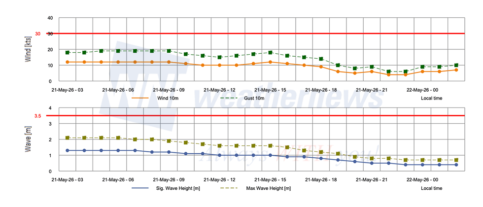
Port Forecast Alert Threshold

■ FATEH TERMINAL, United Arab Emirates
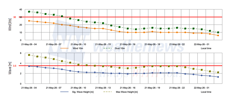
Strong winds and elevated gusts exceed Yellow Caution thresholds through the early morning hours before steadily easing. Waves also breach the Yellow Caution level at the start of the period, gradually subsiding through the day.
Wind: Winds start at 25 kts at 04:00 LT, exceeding the 20 kts Yellow Caution threshold, and ease steadily through the morning, dropping below 20 kts by 09:00 LT before settling to 10 kts by 12:00 LT and holding there for the remainder of the period.
Gust: Gusts peak at 37 kts at 04:00 LT, exceeding the 30 kts Yellow Caution threshold, and gradually subside through the morning, falling below 30 kts by 12:00 LT before tapering to 14 kts by 17:00 LT.
Significant wave height opens at 3.4 m at 04:00 LT, exceeding the 2.5 m Yellow Caution threshold, and steadily diminishes through the day, dropping below 2.5 m by 09:00 LT and continuing to ease to 1.9 m by 16:00–17:00 LT.
■ BASRAH, Iraq
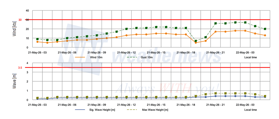
Light winds and negligible waves characterize the day, with a notable wind shift from southerly to northwesterly occurring around 21:00–22:00 LT. All parameters remain well below alert thresholds throughout.
Wind: Winds start at 5–6 kts from the northeast at 03:00 LT, building to a peak of 15 kts from the south-southeast at 15:00–16:00 LT, before dropping briefly to 5 kts at 19:00 LT and then climbing again to 18 kts from the northwest at 21:00–23:00 LT.
Gust: Gusts start at 8–9 kts at 03:00–05:00 LT, rising to 22 kts at 15:00–16:00 LT, then spiking to a peak of 27 kts at 23:00–00:00 LT as northwesterly conditions develop.
Significant wave height starts at 0.1 m at 03:00–04:00 LT, gradually building to a peak of 0.4 m between 21:00–23:00 LT as the wind shift takes effect.
■ RAS LAFFAN, Qatar
Moderate winds ease steadily through the morning before dropping to light and variable conditions by midday. Waves follow a similar declining trend, reaching their lowest point by late evening.
Wind: Winds start at 12 kts at 03:00–09:00 LT and gradually taper through the morning, dropping to 9 kts by 18:00 LT before easing further to 4 kts by 22:00 LT.
Gust: Gusts open at 18–19 kts from 03:00–09:00 LT and steadily subside through the day, declining to 6 kts by 22:00 LT.
Significant wave height begins at 1.3 m at 03:00–06:00 LT and diminishes steadily through the period, settling to 0.4 m by 23:00 LT.
View Full Port List & Detailed Forecasts on SeaNavigator Free
Disclaimer: This outlook is provided for informational purposes only; our actionable, ship-specific advisories are exclusively available through our paid maritime solutions. Weathernews Inc. assumes no liability for navigational decisions, losses, or damages resulting from reliance on this general overview.
Major Ports with Published Port Forecasts
Persian Gulf Region
- United Arab Emirates: Abu Dhabi Port, Dubai Port, Fujairah Port, Khor Fakkan Port, Mubarak Terminal, Fateh Terminal
- Iran: Bandar Abbas Port, Larak Island
- Qatar: Doha Port, Ras Laffan Port
- Bahrain: Bahrain Port, Sitra Port
- Saudi Arabia: Ras Tanura Port, Jubail Port
- Kuwait: Kuwait Port
- Iraq: Al Basrah Oil Terminal
In addition, approximately 150 locations are covered, including ports in the Red Sea and the west coast of India.