About This Outlook
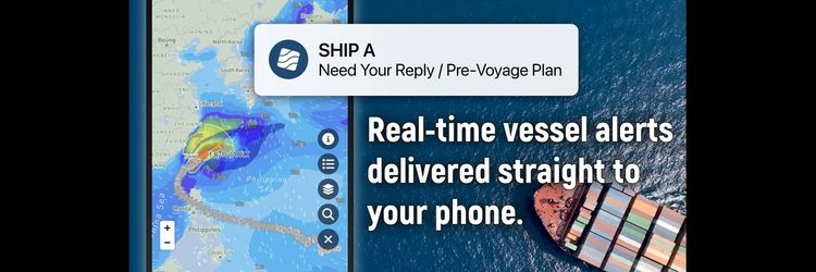
As part of our ongoing commitment to protect mariners' lives and help in times of crisis, Weathernews will be providing daily snapshots of critical port weather trends in the Strait of Hormuz and the Middle East.
Explore this week’s operational weather risks in our [Weekly Outlook].
Free and open access to these forecasts is available via our SeaNavigator Free site.
Reports are updated four times daily and include 48-hour, 5-day and 7-day outlooks for your use.
Daily Port Weather Highlights
This snapshot is based on the 48-hour forecast issued May 22, 2026, at 00:00 UTC.
Port Forecast Alert Threshold

■ DUQM, Oman
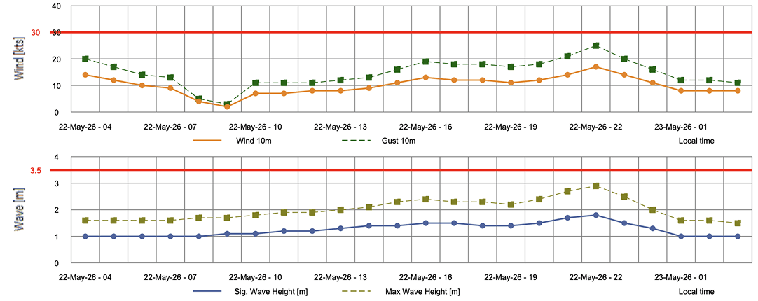
Winds and gusts ease sharply to near-calm conditions by 09:00 LT before gradually climbing to peak values at 22:00 LT. Waves build steadily throughout, also reaching their highest point at 22:00 LT. All parameters remain well below alert thresholds.
Wind: Winds start at 14 kts at 04:00 LT, easing steadily to a minimum of 2 kts at 09:00 LT before climbing back through the day to a peak of 17 kts at 22:00 LT and settling at 14 kts by 23:00 LT.
Gust: Gusts drop from 20 kts at 04:00 LT to 3 kts at 09:00 LT, then build steadily to reach 25 kts at 22:00 LT before pulling back to 20 kts by 23:00 LT.
Wave: Significant wave height holds steady at 1.0 m from 04:00–08:00 LT before gradually building to a peak of 1.8 m at 22:00 LT, then easing to 1.5 m by 23:00 LT.
Additional Note: Sand and dust activity intensifies to severe levels at 11:00–13:00 LT, with visibility dropping sharply to 100 m between 16:00–19:00 LT as fog develops.
■ SITRA, Bahrain
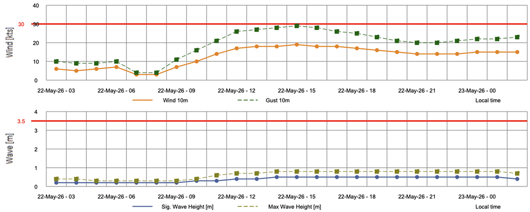
Winds and gusts ease to near-calm at 07:00–08:00 LT before building strongly to peak at 15:00 LT. Waves climb gradually from flat conditions, leveling off at 0.5 m from 14:00 LT through the end of the period. All parameters remain below alert thresholds.
Wind: Winds start at 6 kts at 03:00 LT, dipping to 3 kts at 07:00–08:00 LT before steadily climbing to a peak of 19 kts at 15:00 LT and easing to 14 kts by 21:00 LT.
Gust: After dropping to 4 kts at 07:00–08:00 LT, gusts build strongly through the period, reaching a peak of 29 kts at 15:00 LT before gradually tapering to 20–21 kts by 21:00–23:00 LT.
Wave: Significant wave height remains at 0.2 m from 03:00–09:00 LT before rising incrementally to reach 0.5 m at 14:00 LT, where it holds steady through 23:00 LT.
■ HAMRAWEIN, Egypt
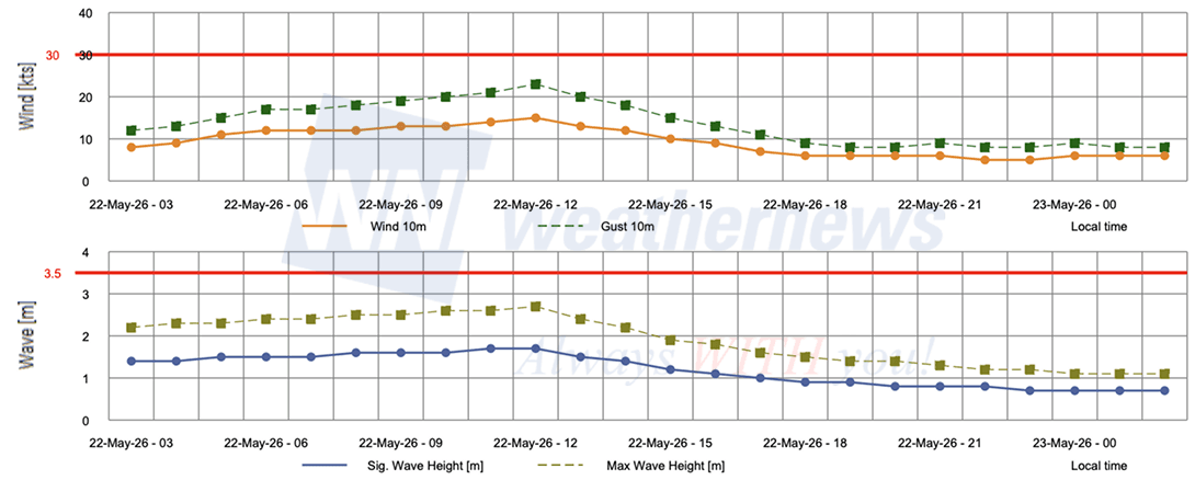
Winds, gusts, and waves all follow a consistent arc on May 22, building steadily to peak at 11:00–12:00 LT before easing through the remainder of the period. Conditions diminish notably by 19:00 LT, with winds and gusts settling to light levels by 23:00 LT. All parameters remain well below alert thresholds.
Wind: Winds build gradually from 8 kts at 03:00 LT to a peak of 15 kts at 12:00 LT before easing steadily to 5 kts by 22:00–23:00 LT.
Gust: Starting at 12 kts at 03:00 LT, gusts rise steadily to reach a peak of 23 kts at 12:00 LT before tapering to 8 kts by 19:00 LT and holding near that level through 23:00 LT.
Wave: Significant wave height rises from 1.4 m at 03:00 LT to a peak of 1.7 m at 11:00–12:00 LT, then declines steadily through the period, reaching 0.7 m by 23:00 LT.
View Full Port List & Detailed Forecasts on SeaNavigator Free
Disclaimer: This outlook is provided for informational purposes only; our actionable, ship-specific advisories are exclusively available through our paid maritime solutions. Weathernews Inc. assumes no liability for navigational decisions, losses, or damages resulting from reliance on this general overview.
Major Ports with Published Port Forecasts
Persian Gulf Region
- United Arab Emirates: Abu Dhabi Port, Dubai Port, Fujairah Port, Khor Fakkan Port, Mubarak Terminal, Fateh Terminal
- Iran: Bandar Abbas Port, Larak Island
- Qatar: Doha Port, Ras Laffan Port
- Bahrain: Bahrain Port, Sitra Port
- Saudi Arabia: Ras Tanura Port, Jubail Port
- Kuwait: Kuwait Port
- Iraq: Al Basrah Oil Terminal
In addition, approximately 150 locations are covered, including ports in the Red Sea and the west coast of India.