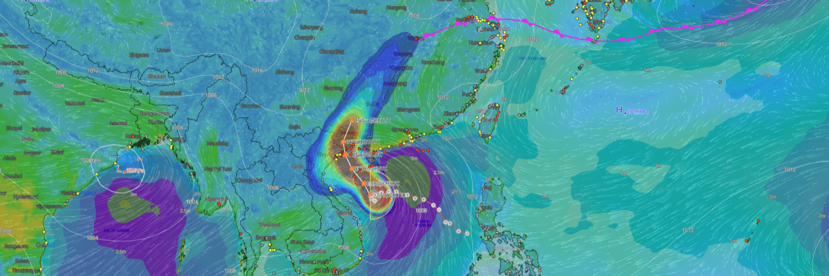
Formerly a tropical depression tracking westward across the South China Sea, the system was officially designated as Typhoon No. 10 (Maysak) upon intensifying into a tropical storm in the early hours of 3 July (JST). Now positioned in the Gulf of Tonkin (Beibu Gulf) near the western approaches of Hainan Island, the storm is forecast to curve northward and make landfall along the Guangxi coast of southern China by 4–5 July, according to the Japan Meteorological Agency (JMA).
CURRENT STATUS
Based on the latest JMA observations on July 2, 2026 21:45 UTC
- Location: 17.5°N, 108.9°E — Gulf of Tonkin (Beibu Gulf)
- Intensity: Tropical Storm
- Movement: West-northwest at less than 5kt (10 km/h)
- Central pressure: 998 hPa
- Maximum sustained winds: 35 kt (65 km/h)
- Maximum gusts: 50 kt (93 km/h)
- 30-kt wind radius: 280 km (150 NM)
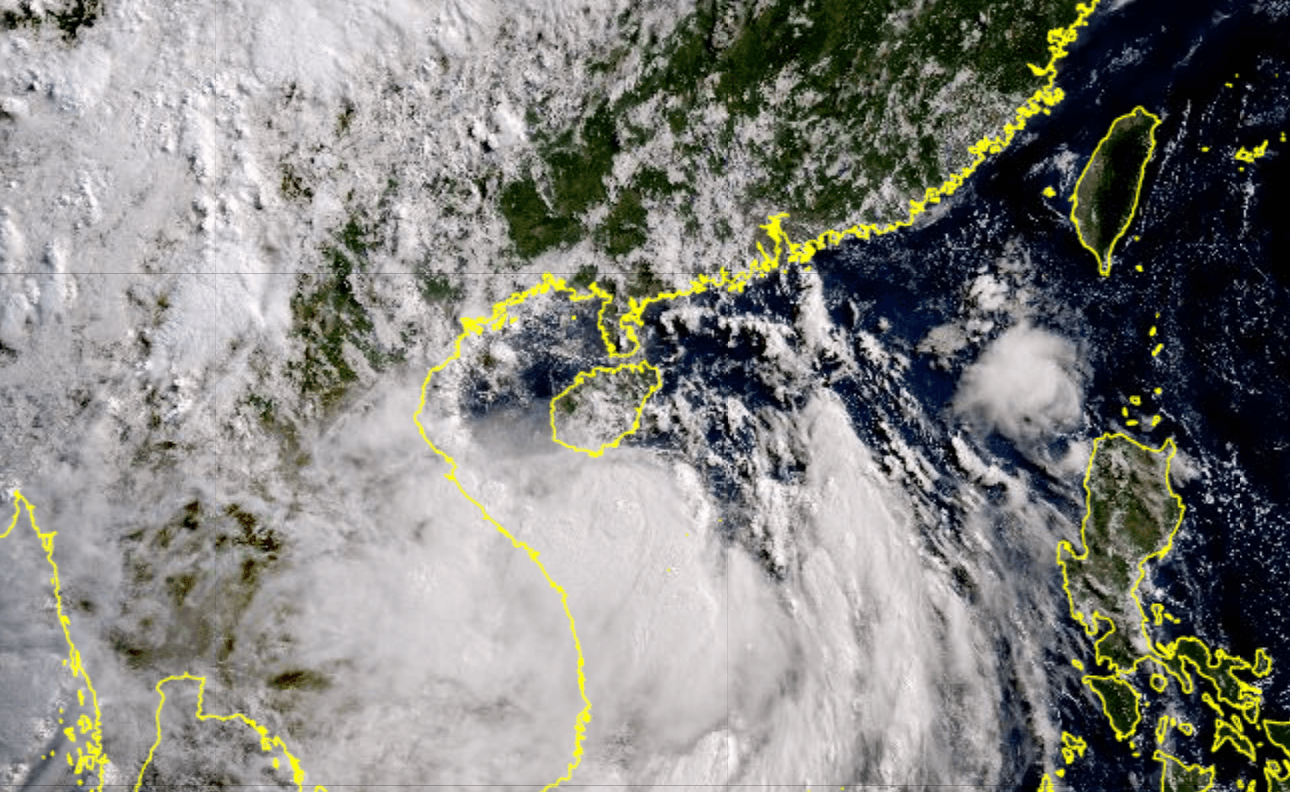
Himawari Satellite Imagery (Visible Color) valid July 3, 2026 00:30 UTC
FORECAST TRACK SUMMARY as of July 2, 2026 21:45 UTC
Currently drifting slowly west-northwestward, Typhoon No. 10 (Maysak) is forecast to turn northward and slow further by 09:00 UTC on 3 July, with the centre projected near 18.3°N, 108.9°E — still over the Gulf of Tonkin. By 21:00 UTC on 3 July, the storm is expected to accelerate northward at 15 km/h (9 kt), placing the centre near 20.1°N, 108.8°E at the northern Gulf of Tonkin approaches.
A gradual shift to north-northwest at 10 km/h (6 kt) is then forecast, bringing the centre near 22.0°N, 108.2°E — inland Guangxi — by 18:00 UTC on 4 July. By 18:00 UTC on 5 July, the remnant circulation is projected near 24.6°N, 109.5°E in central Guangxi, tracking north-northeast at 15 km/h (7 kt).
The probability circle expands from 65 km (35 NM) at the T+12 period to 220 km (120 NM) by 18:00 UTC on 5 July, reflecting growing track uncertainty across the extended forecast range.
INTENSITY FORECAST as of July 2, 2026 21:45 UTC
Sustained at tropical storm intensity through 21:00 UTC on 3 July, the storm is forecast to gradually intensify, reaching peak winds of 40 kt (74 km/h) with gusts to 60 kt (111 km/h) and a minimum central pressure of 994 hPa around 18:00 UTC on 4 July. Weakening is then expected as the system tracks inland, with JMA forecasting a return to tropical depression intensity by 18:00 UTC on 5 July as central pressure rises to 996 hPa.
IMPACTS & THREATS
Moving slowly through the Gulf of Tonkin before curving northward toward the Guangxi coast, the storm presents an extended window of hazardous conditions across southern China and the wider Gulf of Tonkin. Based on the JMA advisory, the following hazards are forecast:
Strong Winds: Peak sustained winds of 40 kt (74 km/h) with gusts reaching 60 kt (111 km/h) are expected around 18:00 UTC on 4 July as the system approaches the Guangxi coast. The current 30-kt wind radius already extends 280 km (150 NM) from the centre, bringing tropical storm-force conditions to a wide area of the Gulf of Tonkin .
Prolonged Exposure: The system's slow forward motion — drifting at less than 10 km/h (5 kt) through the initial forecast periods — extends the duration of tropical storm-force conditions across the Gulf of Tonkin through July 3–4.
OPERATIONAL PORT FORECASTS
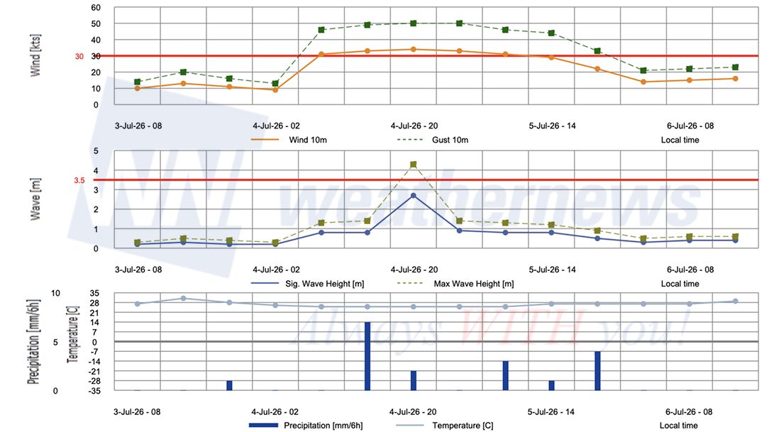
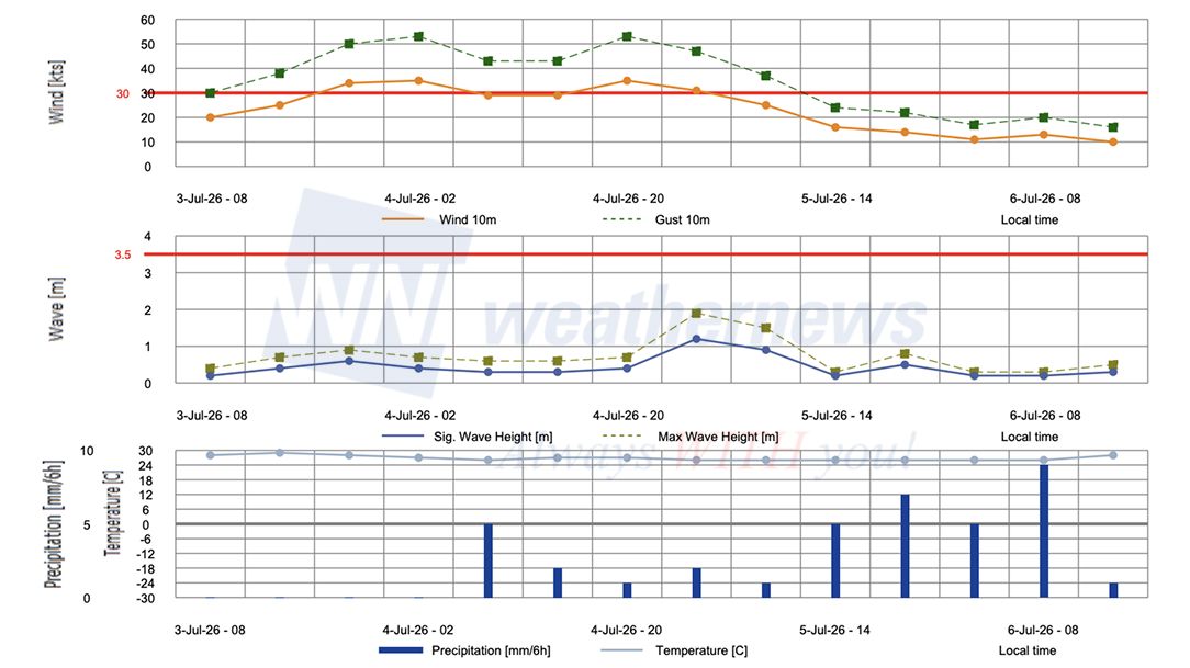
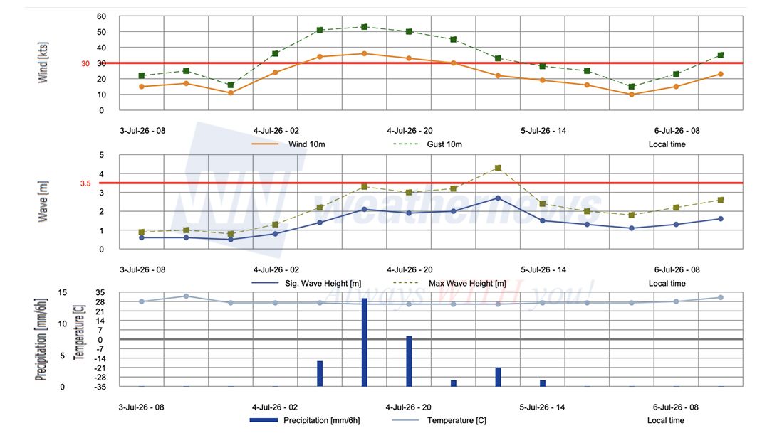
The operational risks associated with this system are most acute along the northern Gulf of Tonkin coastline, where the storm is forecast to track northward toward landfall. The broad 30-kt wind radius of 280 km (150 NM) already brings tropical storm-force conditions to a wide arc of port operations across the Gulf of Tonkin and southern China.
■Qinzhou, Guangxi
■Zhanjiang, Guangdong
■Yangpu, Hainan
Weathernews Inc. assumes no liability for navigational decisions, losses, or damages resulting from reliance on this general overview.
While official observations guide the general threat assessment, highly detailed, proprietary routing and port forecasts are essential for safe navigation. Weathernews services provide customers with 24/7 localized data to ensure your vessels remain safe and well-informed. Please consult our dedicated services for the most up-to-date, detailed predictions for your specific routes and operations.
Note on the storm's name: The name ‘Maysak’ was contributed by Cambodia and refers to the Teak tree (Tectona Grandis). The WMO and the ESCAP/WMO Typhoon Committee adopt these names sequentially to make tracking specific storms straightforward and to quickly communicate warnings. To learn more about how storms are named, please visit the World Meteorological Organization (WMO) website.