Typhoon No. 9 (Bavi) is churning through the western Pacific with maximum sustained winds of 110 kt (204 km/h) and a central pressure of 910 hPa, after passing near the Mariana Islands, and is forecast to reach peak intensity over the Philippine Sea before threatening the Luzon Strait corridor — and potentially Taiwan and the East China Sea — by the end of the forecast period, according to the Japan Meteorological Agency (JMA).
CURRENT STATUS
Based on the latest JMA observations on July 6, 2026 03:45 UTC
- Location: 14.6°N, 144.6°E — approximately 125 km north-northwest of Guam
- Intensity: Violent Typhoon (JMA Grade: TY)
- Movement: WNW at 20 km/h (10 kt), tracking away from the Marianas
- Central pressure: 910 hPa
- Maximum sustained winds: 110 kt (204 km/h); gusts to 155 kt (287 km/h)
- 50-kt storm-force wind radius: 140 km (75 NM)
- 30-kt tropical-storm-force wind radius: 560 km (300 NM) — Large scale
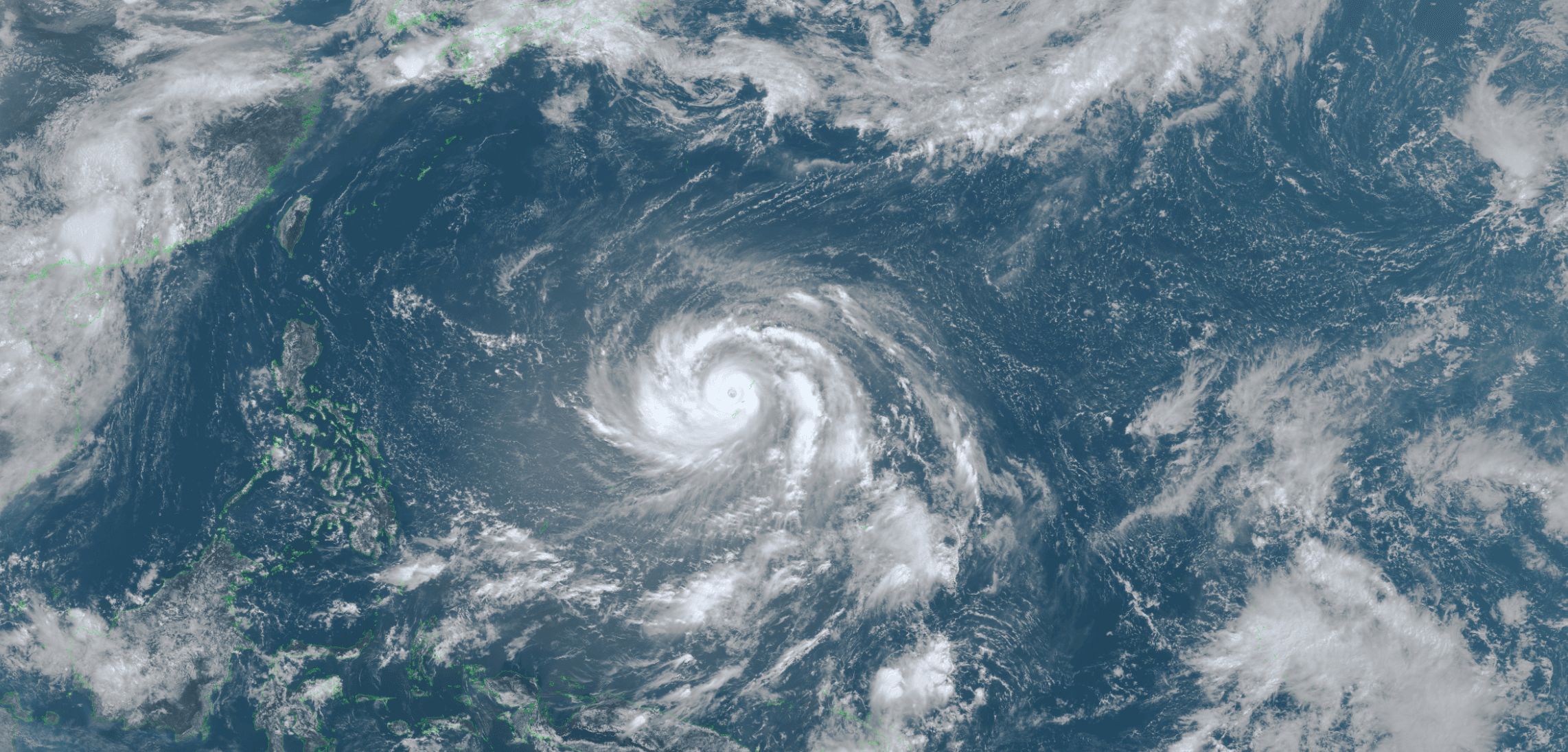
Himawari Satellite Imagery (Visible Color) valid July 6, 2026 02:30 UTC
FORECAST TRACK SUMMARY
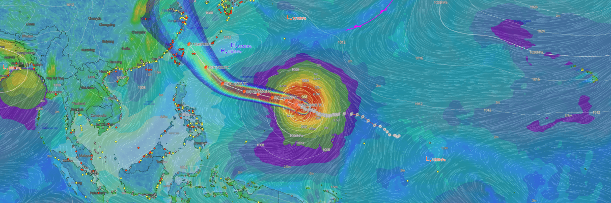
Bavi will continue on a WNW-to-W track across the Philippine Sea over the next 48 hours. The center is forecast near 16.0°N, 138.9°E by 03:00 UTC on 7 July (12:00 JST / 11:00 PHT), and 17.1°N, 134.2°E by 00:00 UTC on 8 July — placing it roughly 1,200 km east of the Philippine archipelago. A subsequent deceleration and shift to WNW movement is expected, with the system positioned near 18.7°N, 129.9°E by 00:00 UTC on 9 July.
A recurvature to the northwest is forecast around 10 July, with the center projected near 21.9°N, 126.4°E by 00:00 UTC — approaching the Luzon Strait between the northern Philippines and Taiwan from the east. By 00:00 UTC on 11 July (09:00 JST / 09:00 CST), Bavi is forecast near 26.0°N, 122.1°E, in the vicinity of the East China Sea northeast of Taiwan.
Track confidence decreases substantially beyond 72 hours. The potential for impacts on northern Luzon, Taiwan, and Japan's Ryukyu Islands will depend critically on the evolution of the subtropical ridge and remains under close watch.
INTENSITY FORECAST
Bavi is forecast to undergo modest additional intensification over the next 24–45 hours, with JMA projecting central pressure to deepen to 905 hPa and maximum winds to reach 115 kt (213 km/h) by 03:00 UTC on 7 July, before arriving at a forecast peak of 900 hPa and 115 kt around 00:00 UTC on 8 July — a deepening of 10 hPa over approximately 45 hours.
A gradual weakening trend is expected from 9 July, with central pressure rebounding to 905 hPa / 110 kt before the system transitions from Violent to "Very Strong" intensity sometime on 10 July, when JMA forecasts 920 hPa and 100 kt (185 km/h). The weakening trend continues to 935 hPa and 90 kt (167 km/h) by 11 July. Despite this steady easing, Bavi is expected to remain a powerful typhoon throughout the entire 5-day forecast window.
INTENSITY IN CONTEXT
Bavi currently sits at the pinnacle of JMA's four-tier intensity scale under the "Violent" designation. By the classification standard used by the U.S. military's Joint Typhoon Warning Center (JTWC), the storm also qualifies as a "super typhoon" — a label reserved for the most powerful tropical cyclones in the Northwest Pacific basin.
IMPACTS & THREATS
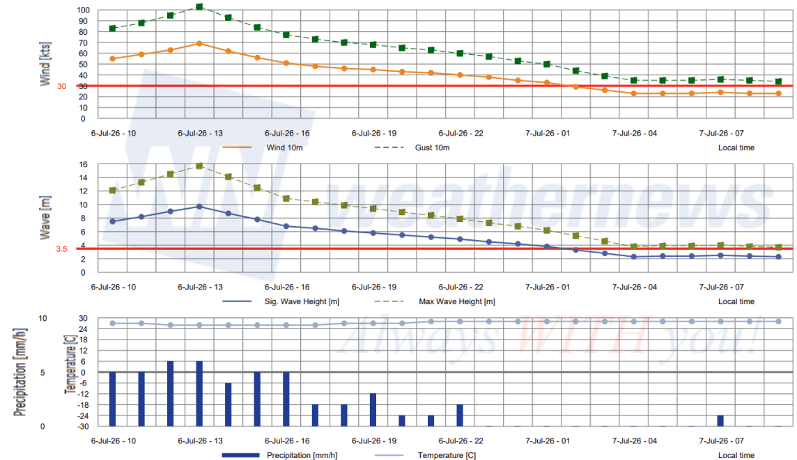
Classified as a Large storm, Typhoon No. 9 (Bavi)'s tropical-storm-force wind field currently extends 560 km (300 NM) from the center — an area that will grow further as the system approaches the Luzon Strait. At the time of analysis, the center passed approximately 125 km north-northwest of Guam, placing the island within the storm's 50-kt storm-force wind radius of 140 km. The immediate threat to the Marianas is diminishing as Bavi tracks westward.
Shipping interests across the western Philippine Sea should exercise extreme caution in the days ahead. As the system approaches the Luzon Strait and East China Sea corridor on 10–11 July, northern Luzon, Taiwan, and the Ryukyu Islands of southern Japan may face heavy rainfall, destructive winds, and significant storm surge. Residents and authorities in these regions are urged to monitor subsequent advisories closely.
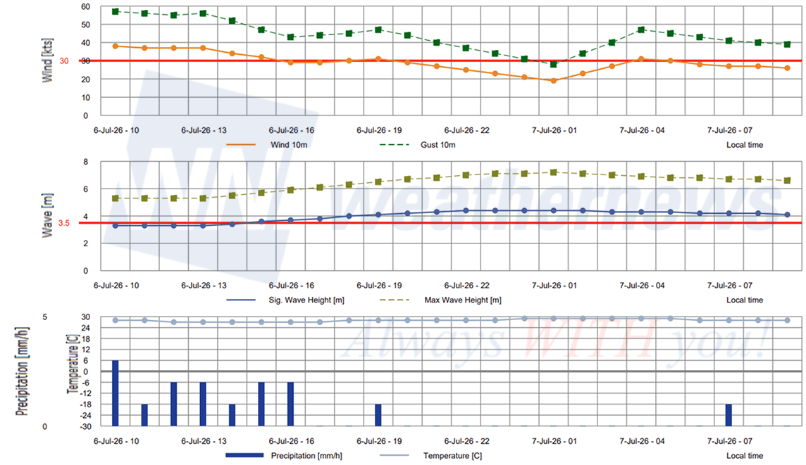
OPERATIONAL PORT FORECASTS
■GUAM, Mariana Islands
■SAIPAN, Mariana Islands
Weathernews Inc. assumes no liability for navigational decisions, losses, or damages resulting from reliance on this general overview.
While official observations guide the general threat assessment, highly detailed, proprietary routing and port forecasts are essential for safe navigation. Weathernews services provide customers with 24/7 localized data to ensure your vessels remain safe and well-informed. Please consult our dedicated services for the most up-to-date, detailed predictions for your specific routes and operations.
Note on the storm's name: The name ‘Bavi’ was contributed by Vietnam and refers to a mountain chain in northern Vietnam. The WMO and the ESCAP/WMO Typhoon Committee adopt these names sequentially to make tracking specific storms straightforward and to quickly communicate warnings. To learn more about how storms are named, please visit the World Meteorological Organization (WMO) website.