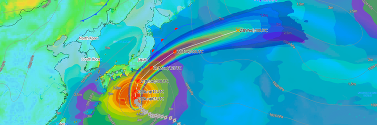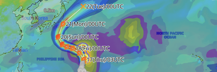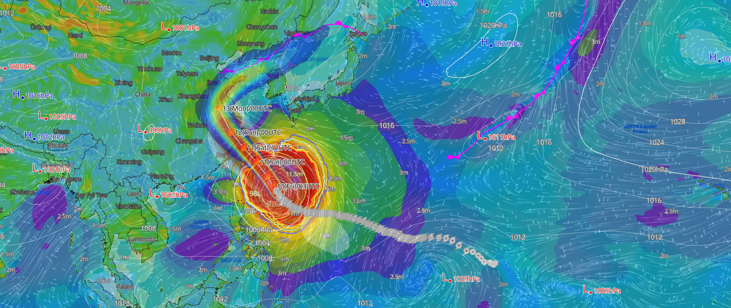
Classified as large and very strong by the Japan Meteorological Agency (JMA), Typhoon No. 9 (Bavi) is moving west-northwestward at a slower pace. The typhoon is projected to pass between Japan's Miyako and Ishigaki island groups on July 11 (Japan local time) before accelerating toward China's Zhejiang-Fujian coast. Violent winds, extreme seas and storm surge remain a severe threat for the Okinawa region.
CURRENT STATUS
Based on the latest JMA observations as of July 10, 2026 03:45 UTC
- Location: 20.8°N, 127.1°E — approximately 480 km south-southeast of Miyakojima
- Classification: Large and Very Strong Typhoon
- Movement: West-northwest at 10 km/h (6 kt)
- Central pressure: 935 hPa
- Maximum sustained winds: 85 kt (157 km/h)
- Maximum gusts: 120 kt (222 km/h)
- ≥50-kt wind radius: 330 km (180 NM) NE, 280 km (150 NM) SW
- ≥30-kt wind radius: 750 km (400 NM) NE, 700 km (375 NM) SW
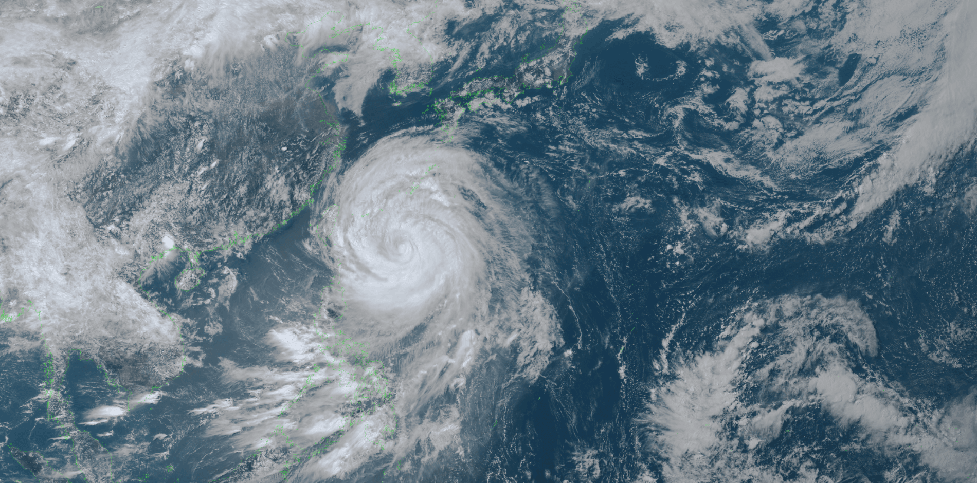
Himawari Satellite Imagery (Visible Color) valid July 10, 2026 05:40 UTC
FORECAST TRACK SUMMARY
Currently drifting west-northwestward at 10 km/h (6 kt), Typhoon No. 9 (Bavi) is forecast to accelerate northwestward, placing the centre approximately 150 km south-southeast of Miyakojima (23.5°N, 125.8°E) by 15:00 UTC on 10 July. Continuing at 30 km/h (15 kt), the storm is then projected approximately 160 km north-northwest of Ishigakijima (25.7°N, 123.6°E) by 03:00 UTC on 11 July — passing between the Miyako and Ishigaki island groups.
The system then tracks toward the Chinese coast, with the center forecast at approximately 65 km north-northwest of Lishui, in inland Zhejiang province (28.8°N, 119.4°E), by 00:00 UTC on 12 July. Continuing north-northwest and then north-northwestward, the remnant is projected approximately 80 km north-northwest of Hefei, Anhui province (32.4°N, 116.9°E) by 00:00 UTC on 13 July before weakening to a tropical depression approximately 70 km east-northeast of Xuzhou, near the Jiangsu-Shandong border (34.6°N, 117.8°E) by 00:00 UTC on 14 July.
INTENSITY FORECAST
Maintaining very strong intensity with a central pressure of 935 hPa and maximum sustained winds of 85 kt (157 km/h) through 15:00 UTC on 10 July, Typhoon No. 9 (Bavi) is forecast to weaken slightly ahead of its passage through the Sakishima corridor. By 03:00 UTC on 11 July, the JMA projected the storm at the strong intensity grade, with central pressure rising to 940 hPa and maximum sustained winds of 80 kt (148 km/h). Further weakening follows as the system approaches China: central pressure is forecast at 970 hPa with sustained winds of 50 kt (93 km/h) by 00:00 UTC on 12 July, easing to 990 hPa and 35 kt (65 km/h) by 00:00 UTC on 13 July, before the system transitions to a tropical depression at 994 hPa by 00:00 UTC on 14 July.
IMPACTS & THREATS
Forecast to pass between the Miyako and Ishigaki island groups at strong to very strong intensity, the storm is expected to bring violent and destructive conditions to the Okinawa region through 11 July. The JMA has issued warnings for the following hazards:
Violent Winds: From the evening of 10 July (JST), gale-force conditions are expected across Okinawa, intensifying to violent winds through 11 July. JMA forecasts maximum sustained winds of 68 kt (126 km/h) with gusts to 97 kt (180 km/h) over Okinawa on 10 July, increasing to 85 kt (157 km/h) sustained with gusts to 115 kt (213 km/h) on 11 July — conditions described by JMA as capable of partially collapsing structures. The Amami region is forecast to experience sustained winds of 35 kt (65 km/h) with gusts to 58 kt (108 km/h) on both 10 and 11 July.
Extreme Rainfall: Thunderstorms and very heavy rainfall are forecast across the Sakishima Islands through 11 July. JMA forecasts up to 250 mm of rainfall over Okinawa in the 24 hours from 12:00 JST on 10 July, with an additional 100 mm expected over the following 24 hours through 12:00 JST on 12 July.
Dangerous Waves: Seas are forecast to be extremely rough across Okinawa and the Amami region through 11 July. Wave heights of up to 13 metres with swells are expected in Okinawa on both 10 and 11 July, easing to 8 metres on 12 July. Amami will experience waves up to 9 metres through 11 July, easing to 6 metres on 12 July. Southern Kyushu can expect 5–6 metre seas with swells through 11 July.
Storm Surge: From late night 10 July through the morning of 11 July (JST), JMA warns of elevated tidal levels posing a risk of serious damage to coastal facilities. Low-lying coastal and estuarine areas face a risk of inundation from storm surge and wave action combined.
OPERATIONAL PORT FORECASTS
The operational risks vary by location and timing across the projected track. Ports across the Okinawa Prefecture face the most immediate and severe exposure as the typhoon passes through the Sakishima Islands corridor, while ports along China's Zhejiang and Fujian coasts will experience deteriorating conditions following landfall.
■ISHIGAKI, Yaeyama Islands, Japan
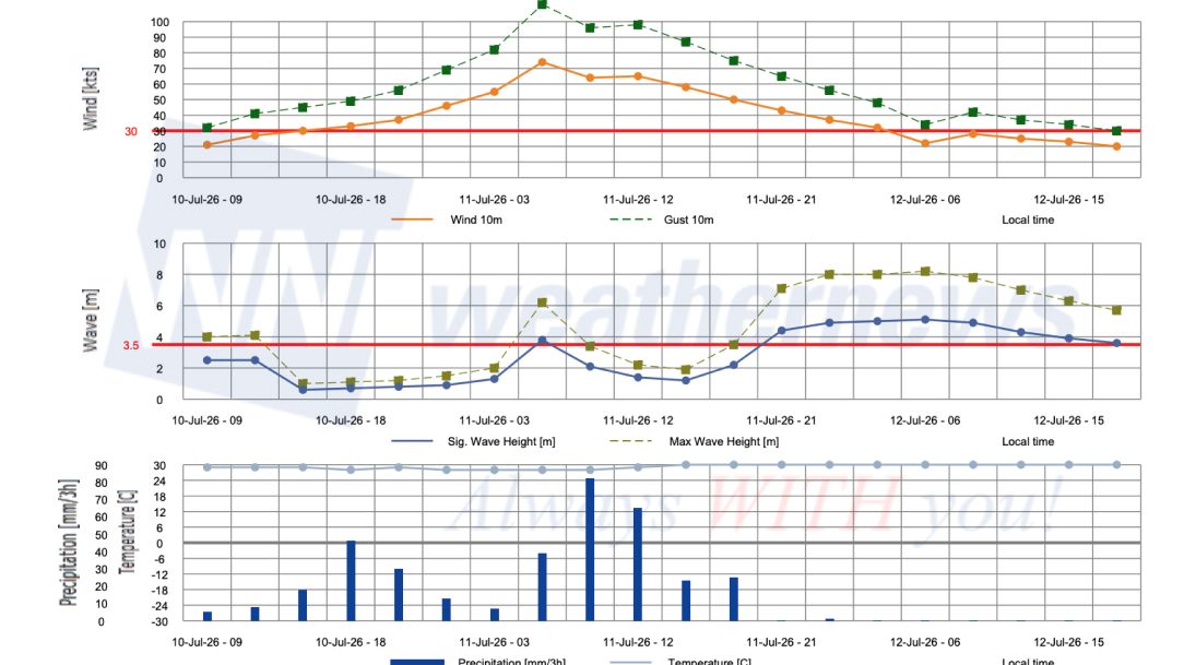
■NAHA, Okinawa Islands, Japan
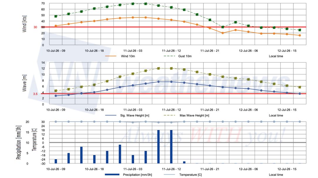
■WENZHOU, Zhejiang, China
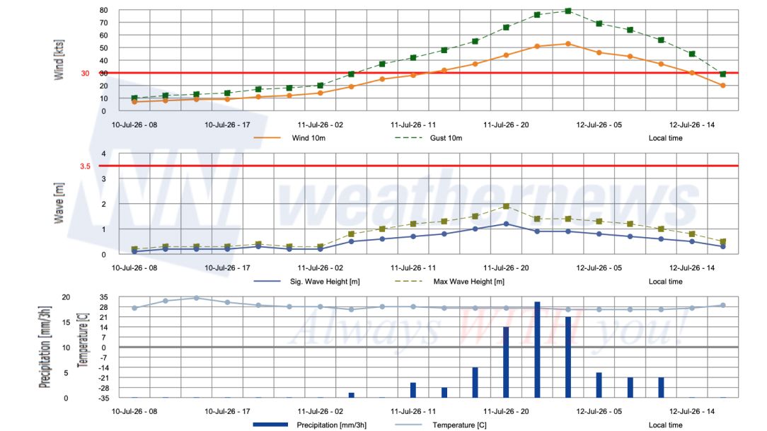
■KEELUNG, Taiwan
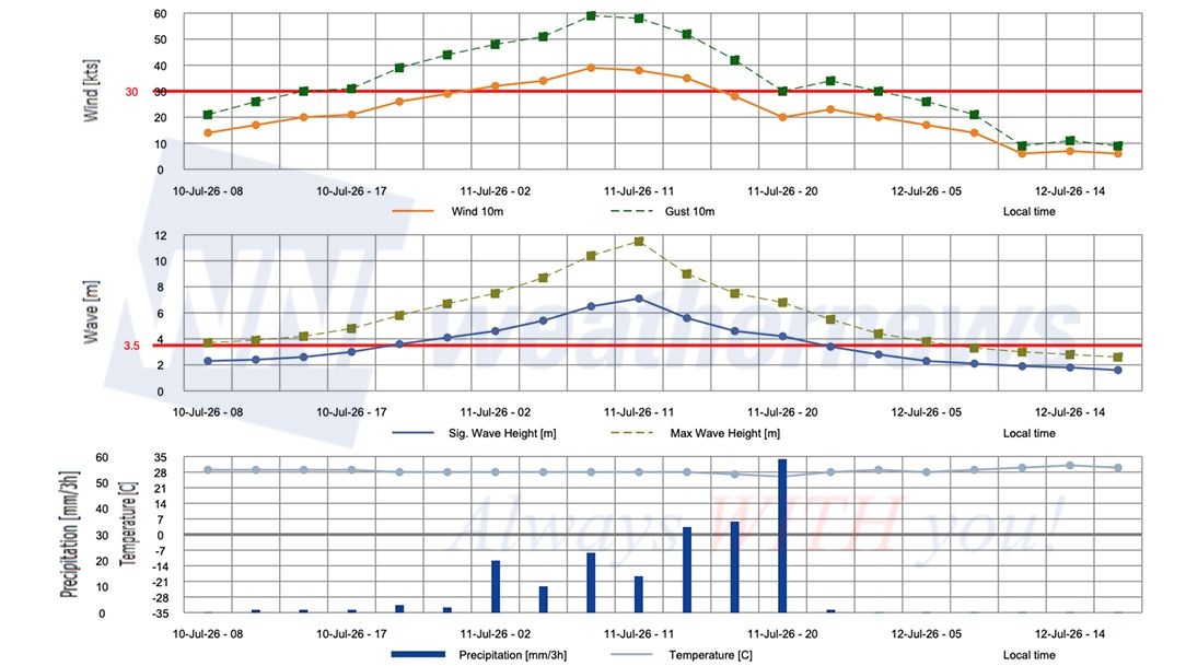
Weathernews Inc. assumes no liability for navigational decisions, losses, or damages resulting from reliance on this general overview.
While official observations guide the general threat assessment, highly detailed, proprietary routing and port forecasts are essential for safe navigation. Weathernews services provide customers with 24/7 localized data to ensure your vessels remain safe and well-informed. Please consult our dedicated services for the most up-to-date, detailed predictions for your specific routes and operations.
Note on the storm's name: The name ‘Bavi’ was contributed by Vietnam and refers to a mountain chain in northern Vietnam. The WMO and the ESCAP/WMO Typhoon Committee adopt these names sequentially to make tracking specific storms straightforward and to quickly communicate warnings. To learn more about how storms are named, please visit the World Meteorological Organization (WMO) website.