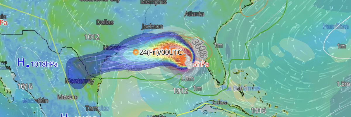
Tropical Storm Bertha has strengthened over the northern Gulf of Mexico, with maximum sustained winds of 50 mph (85 km/h) and central pressure falling to 998 hPa as of 06:00 UTC on 21 July. Moving slowly northwestward, the storm is forecast to make landfall along the southeastern Louisiana coast before 00:00 UTC on 23 July, bringing storm surge, heavy rainfall, and tropical storm-force winds to the northern Gulf Coast through 22–23 July, according to the National Hurricane Center (NHC).
CURRENT STATUS
Based on the latest NHC Public Advisory analysis on July 21, 2026 06:00 UTC
- Location: 28.4°N, 86.1°W — approximately 205 km (125 mi) south of Panama City, Florida; approximately 320 km (200 mi) southeast of Mobile, Alabama
- Intensity: Tropical Storm
- Movement: Northwest at 2 mph (4 km/h)
- Maximum sustained winds: 50 mph (85 km/h)
- Gusts: Higher than 50 mph *specific value not provided in this advisory
- Central pressure: 998 hPa
- 34-kt (tropical-storm-force) wind radius: 110 km (60 NM)
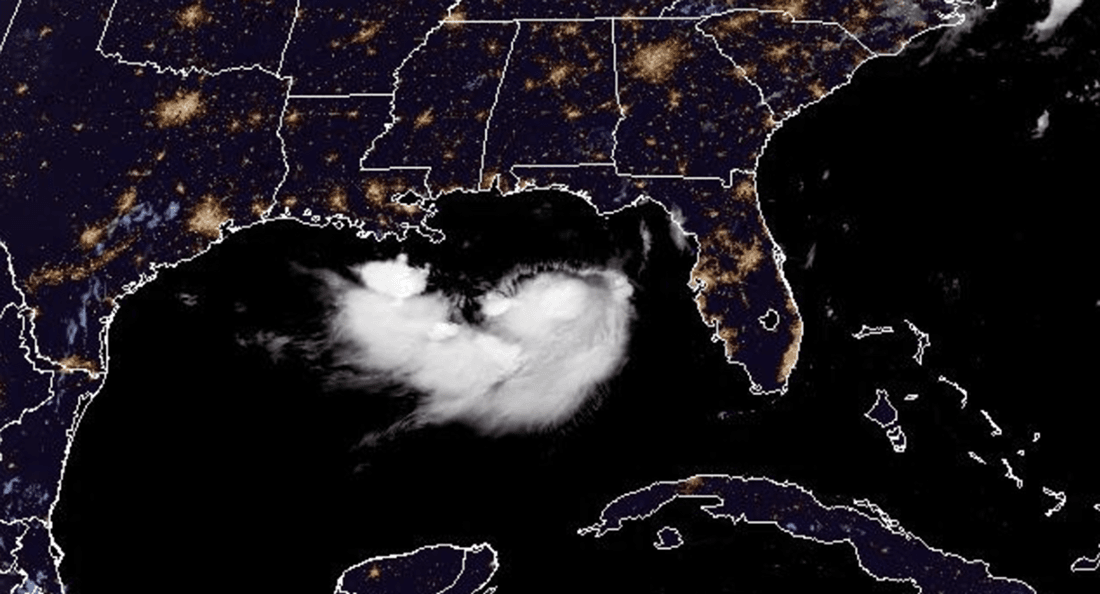
GOES Floater Imagery valid 21 July, 2026 08:21 UTC
FORECAST TRACK SUMMARY
Nearly stationary as of 03:00 UTC on 21 July, Tropical Storm Bertha is forecast to adopt a slow northwestward to west-northwestward motion later on 21 July before turning westward by approximately 22 July. By 12:00 UTC on 21 July, the centre is projected near 28.8°N, 86.6°W—approximately 178 km (110 mi) south of Destin, Florida. The system is then forecast near 29.1°N, 87.3°W by 00:00 UTC on 22 July—approximately 190 km (118 mi) south-southeast of Mobile, Alabama—before reaching near 29.3°N, 88.1°W by 12:00 UTC on 22 July, approximately 156 km (97 mi) south of Mobile, Alabama.
Landfall is expected along the southeastern Louisiana coast, with the centre projected inland near 29.3°N, 89.4°W—approximately 103 km (64 mi) south-southeast of New Orleans, Louisiana—by 00:00 UTC on 23 July. The system then continues westward to near 29.3°N, 90.7°W—approximately 97 km (60 mi) south-southwest of New Orleans—by 12:00 UTC on 23 July.
The remnant circulation is forecast to re-emerge over Gulf waters near 29.3°N, 92.1°W—approximately 100 km (62 mi) south of Lafayette, Louisiana—by 00:00 UTC on 24 July. The system is projected near 29.3°N, 94.6°W—approximately 95 km (59 mi) south-southwest of Port Arthur, Texas—by 00:00 UTC on 25 July, before transitioning to a post-tropical system near 29.3°N, 97.0°W—approximately 164 km (102 mi) west-southwest of Houston, Texas—by 00:00 UTC on 26 July.
NHC notes average track forecast errors of approximately 125 NM (230 km) by 25 July and 175 NM (325 km) by 26 July, with intensity errors of approximately 15 kt per day across the extended period.
IMPACTS & THREATS
Forecast to track near or along the northern Gulf Coast through approximately 22–23 July, the storm presents multiple hazards for coastal and marine operations.
Storm Surge: NHC forecasts the most significant inundation of 2–4 ft (0.6–1.2 m) along the Alabama/Florida border to the mouth of the Mississippi River, with 1–3 ft (0.3–0.9 m) expected across the Florida Gulf Coast, coastal Louisiana, and Lake Pontchartrain. The deepest water will occur along the immediate coast, with surge impacts varying greatly over short distances depending on the timing relative to the tidal cycle.
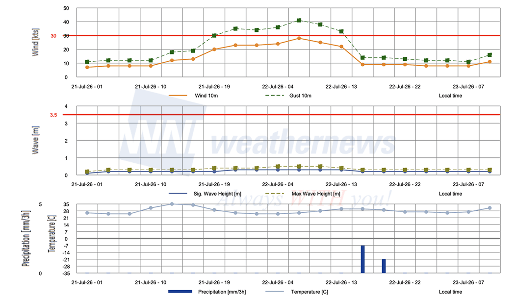
Tropical Storm-Force Winds: Tropical storm conditions are expected along the northern Gulf Coast by late on 21 July into 22 July. Peak sustained winds of 45 kt (83 km/h) with gusts to 55 kt (102 km/h) are forecast at 00:00 UTC on 22 July ahead of landfall.
Rainfall: NHC forecasts 2–4 inches (50–100 mm) with isolated totals up to 8 inches (200 mm) through 23 July across the Gulf Coast and adjacent inland locations from western Florida into southern Louisiana, including southern Alabama and Mississippi. Localised flash flooding is possible, especially in urban areas.
Dangerous Surf: Swells are affecting the Gulf coast of Florida and are forecast to spread westward through the week, producing rough surf conditions and elevated rip current activity.
Local products referenced are issued by National Weather Service Weather Forecast Offices (WFO) for their respective County Warning Areas (CWA). These products provide area-specific details on hazardous weather conditions, storm impacts, and precautions necessary to protect life and property within each office's forecast area.
OPERATIONAL PORT FORECASTS
The operational risks vary by location along the projected track. Ports from Mobile Bay to southeastern Louisiana now fall within the NHC Tropical Storm Warning zone, with the 34-kt wind field reaching 80 NM (148 km) in the southeast and southwest quadrants on 22 July—the widest operational impact window for marine operations
■MOBILE, Alabama, USA
■NEW ORLEANS, Louisiana, USA
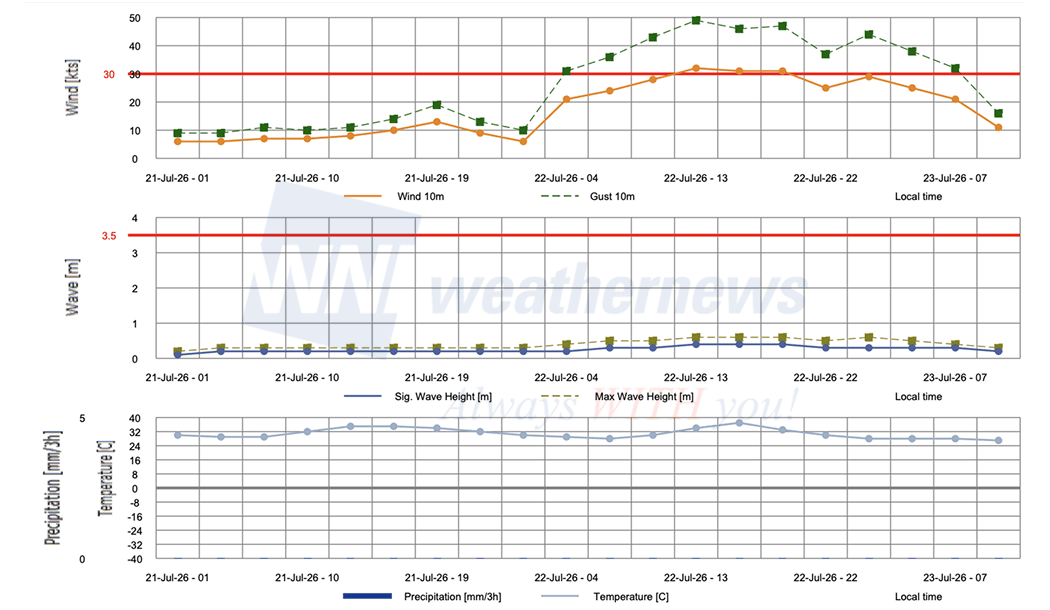
■PASCAGOULA, Mississippi, USA
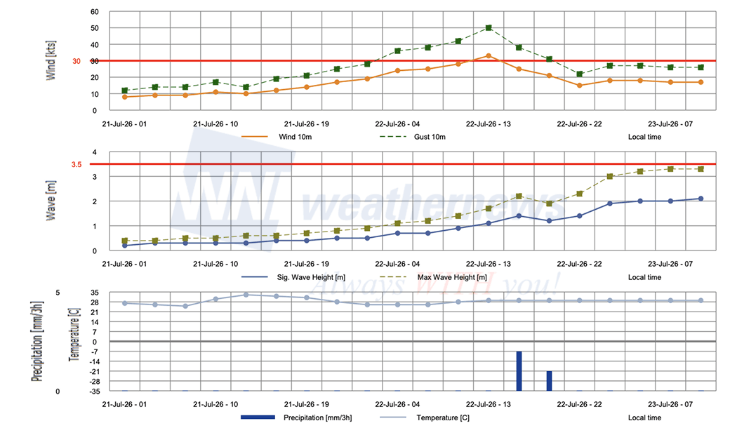
■GULFPORT, Mississippi, USA
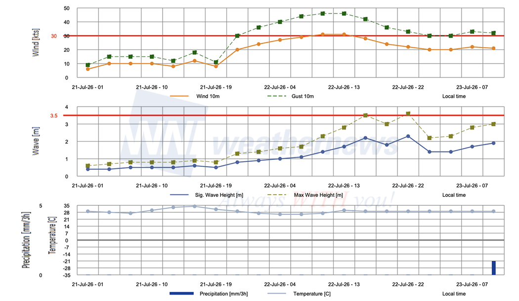
Weathernews Inc. assumes no liability for navigational decisions, losses, or damages resulting from reliance on this general overview.
While official observations guide the general threat assessment, highly detailed, proprietary routing and port forecasts are essential for safe navigation. Weathernews services provide customers with 24/7 localized data to ensure your vessels remain safe and well-informed. Please consult our dedicated services for the most up-to-date, detailed predictions for your specific routes and operations.
Note on the storm's name: "Bertha" is drawn from the 2026 Atlantic tropical cyclone name list, the second name in the season's sequence. Atlantic tropical cyclone names are pre-selected from six rotating lists, with English, French and Spanish names used in balance to reflect the geographical coverage of Atlantic and Caribbean storms. The lists are gender balanced and respectful of societal sensitivities, and names must be instantly recognizable in the interests of safety. A name may be retired from the active list if a tropical cyclone acquires special notoriety due to human casualties and damage incurred. To learn more about how storms are named, please visit the World Meteorological Organization (WMO) website.