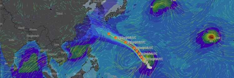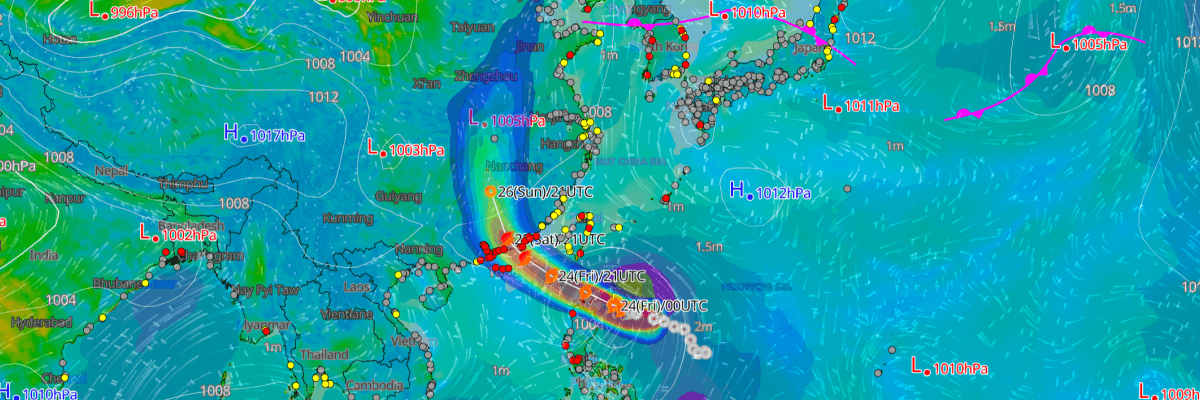
Tropical Storm No. 12 (Noul) is tracking rapidly westward through the Luzon Strait and is forecast to strengthen to a Severe Tropical Storm within 12 hours as it enters the South China Sea, with a landfall threat growing for the southeastern coast of China, according to the Japan Meteorological Agency (JMA).
CURRENT STATUS
Based on the latest JMA observations on July 24, 2026 00:45 UTC
- Location: 18.0°N, 123.5°E — approximately 150 km east of northern Luzon, Philippines
- Grade: Tropical Storm (JMA Grade: TS)
- Movement: W at 30 km/h (15 kt)
- Central pressure: 996 hPa
- Maximum sustained winds: 40 kt (74 km/h); gusts to 60 kt (111 km/h)
- 30-kt tropical-storm-force wind radius: 330 km (180 NM)
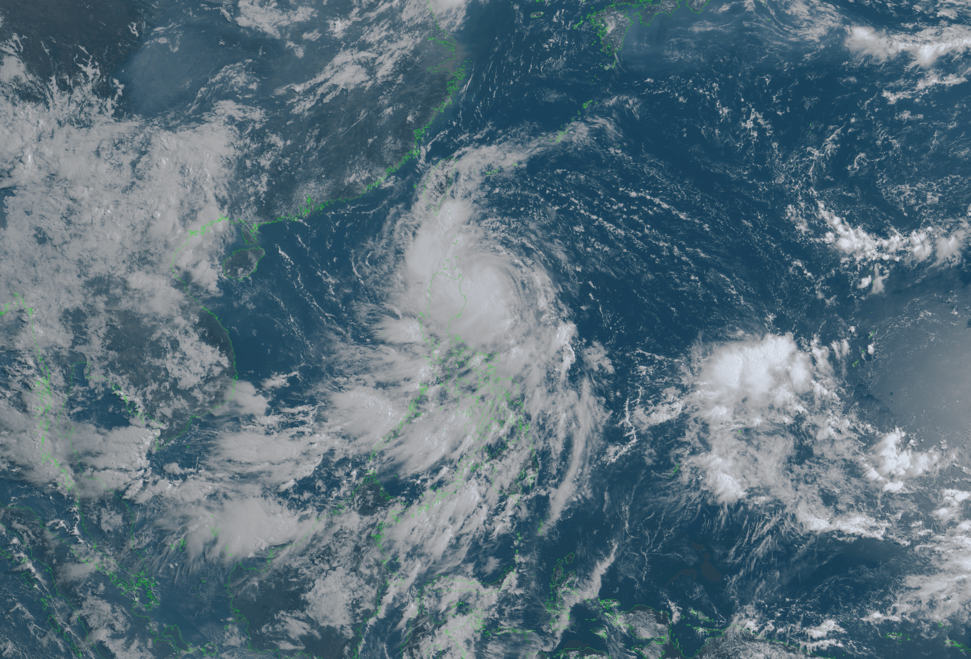
Himawari Satellite Imagery (Visible Color) valid July 24, 2026 00:30 UTC
FORECAST TRACK SUMMARY
Noul is forecast to pass through the Luzon Strait by 12:00 UTC on 24 July (20:00 HKT / 21:00 JST), with the center projected near 19.6°N, 121.0°E. The system will then track WNW across the northern South China Sea, reaching 20.6°N, 118.5°E by 00:00 UTC on 25 July (08:00 HKT / 09:00 JST).
A gradual recurvature to the northwest is forecast from 25 July onward, placing the center near 23.1°N, 114.8°E by 00:00 UTC on 26 July — in the vicinity of Guangdong province, China, near or just inland of the coast northeast of Hong Kong. Landfall is expected sometime between 25 and 26 July as the system approaches the Pearl River Delta region.
After landfall, the system is forecast to slow further and track NNW into the interior, with the center reaching 26.6°N, 113.4°E — deep inside the Guangdong–Hunan corridor — by 00:00 UTC on 27 July.
INTENSITY FORECAST
JMA forecasts Noul to intensify rapidly from Tropical Storm to Severe Tropical Storm status within 12 hours, with maximum sustained winds reaching 50 kt (93 km/h) and central pressure deepening to 990 hPa by 12:00 UTC on 24 July. Strengthening is expected to continue through 25 July, with the system forecast to reach a peak intensity of 60 kt (111 km/h) and 980 hPa by 00:00 UTC on 26 July — immediately prior to or at landfall.
Rapid weakening is then forecast as the storm moves ashore and over land, with JMA projecting a transition to Tropical Depression status and a central pressure rebound to 996 hPa by 00:00 UTC on 27 July.
IMPACTS & THREATS
The Luzon Strait, northern Philippines, and Taiwan's southern tip are expected to experience deteriorating conditions over the next 12–24 hours as Noul passes through the region, with tropical-storm-force winds extending 330 km (180 NM) from the center.
The most significant threat is to coastal Guangdong, Hong Kong, and Macau, where the storm is expected to arrive as a Severe Tropical Storm at or near peak intensity. JMA's forecast storm warning area at landfall extends asymmetrically — up to 260 km (140 NM) on the southeastern flank and 190 km (105 NM) to the northwest — reflecting the elevated risk to areas southeast of the track. Residents and authorities in these areas should prepare for destructive winds, heavy rainfall, and storm surge.
OPERATIONAL PORT FORECASTS
■SHANTOU, China
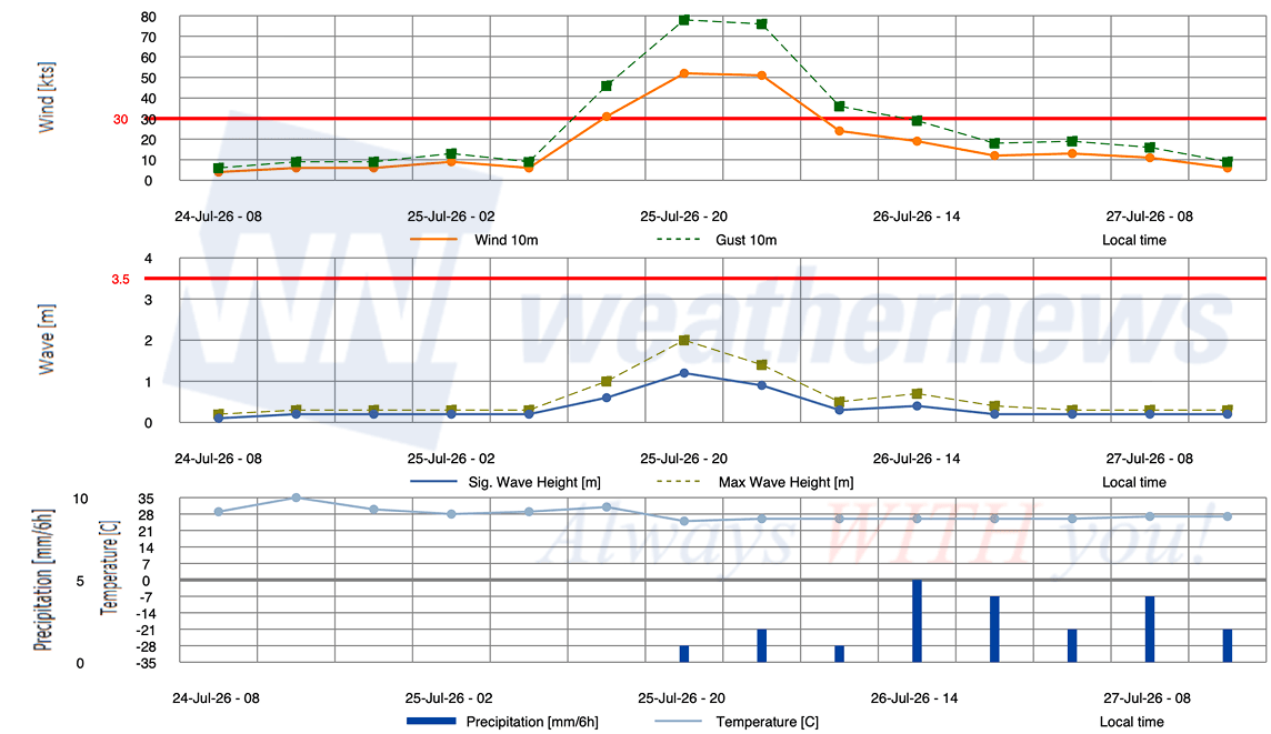
■GUANGZHOU, China
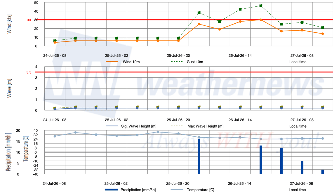
■SHENZHEN, China
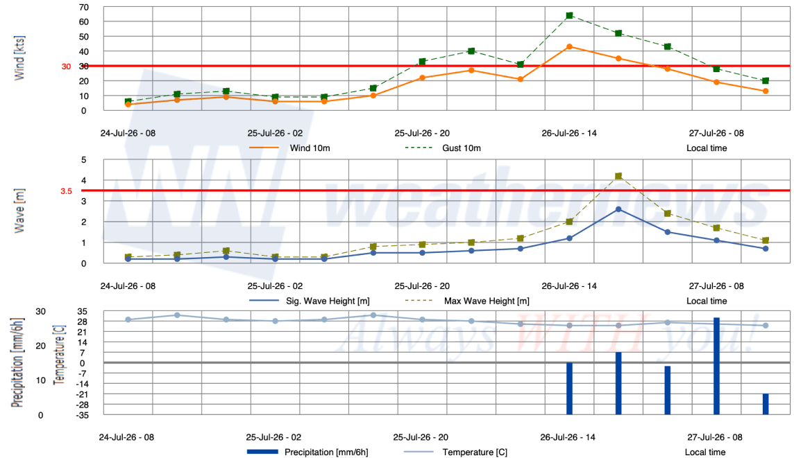
■GUANGDONG TERMINAL, China
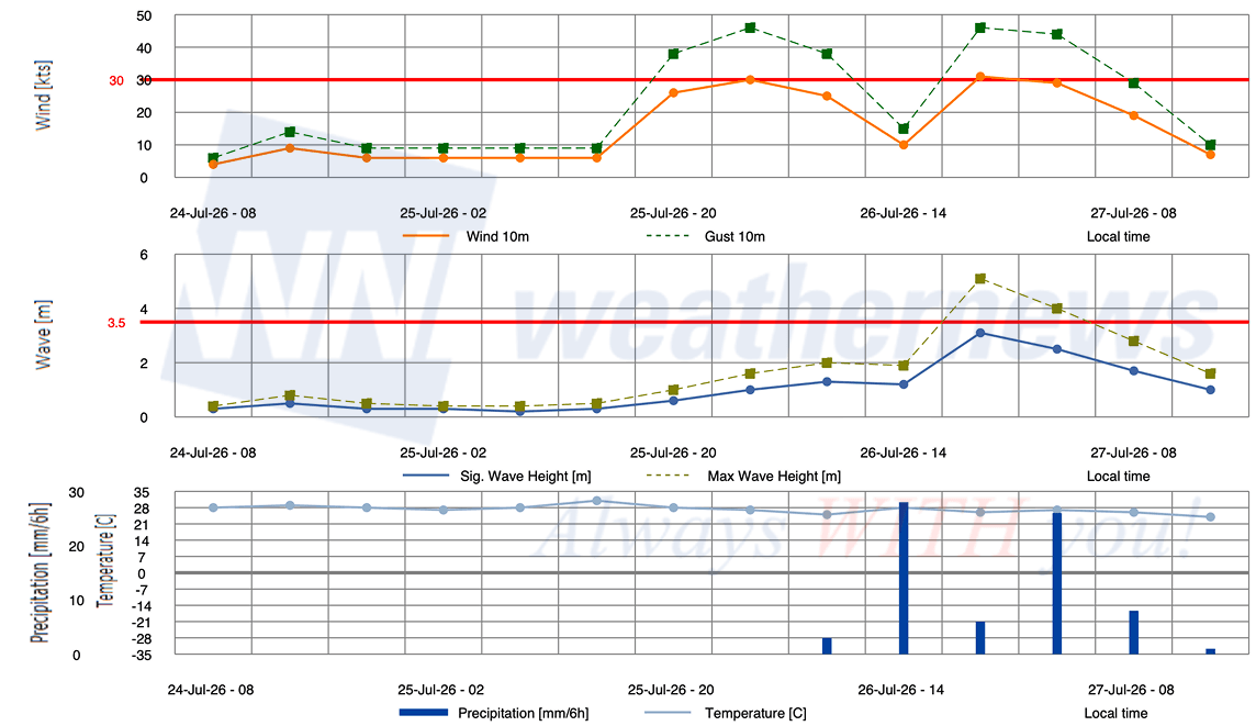
■HONG KONG, Hong Kong
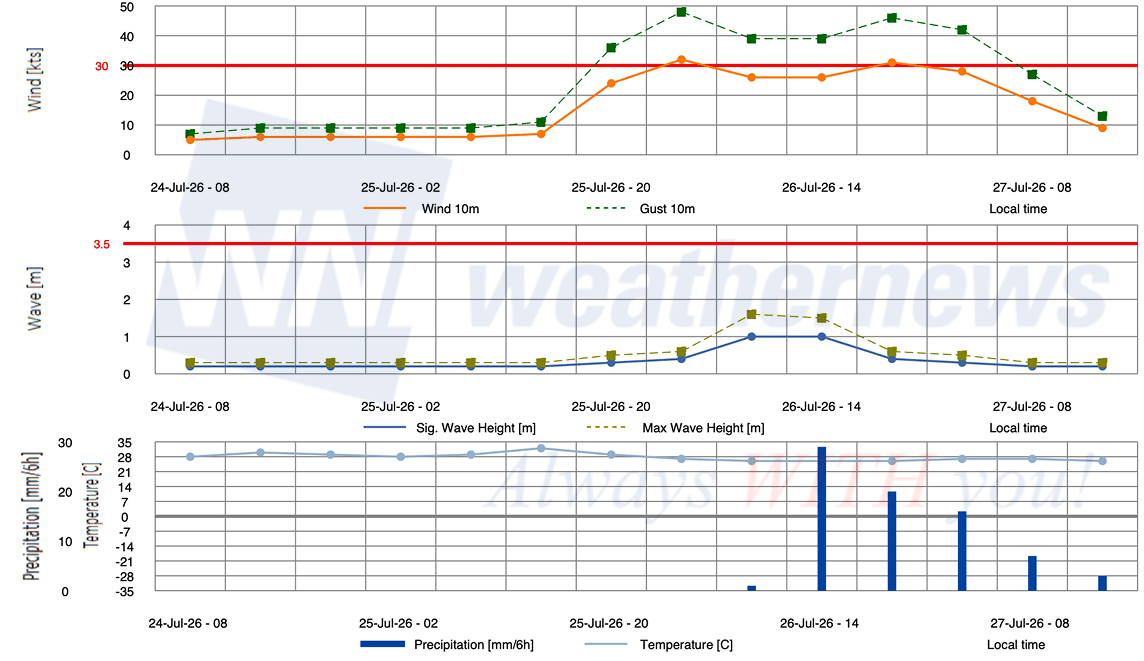
Weathernews Inc. assumes no liability for navigational decisions, losses, or damages resulting from reliance on this general overview.
While official observations guide the general threat assessment, highly detailed, proprietary routing and port forecasts are essential for safe navigation. Weathernews services provide customers with 24/7 localized data to ensure your vessels remain safe and well-informed. Please consult our dedicated services for the most up-to-date, detailed predictions for your specific routes and operations.
Note on the storm's name: The name ‘Noul’ was contributed by DPR Korea and refers to 'glows' or red sky. The WMO and the ESCAP/WMO Typhoon Committee adopt these names sequentially to make tracking specific storms straightforward and to quickly communicate warnings. To learn more about how storms are named, please visit the World Meteorological Organization (WMO) website.