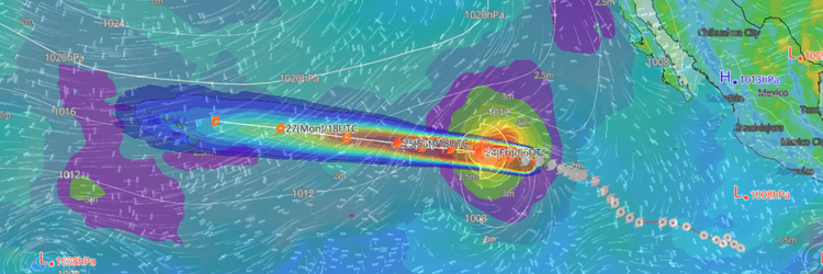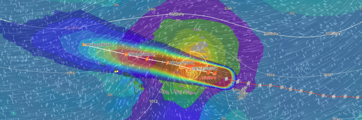
Tropical Storm Fausto is weakening as it tracks west-northwest toward the Hawaiian Islands, with no coastal watches or warnings in effect. At 5:00 PM Hawaiian Standard Time (HST) Monday, July 27, Fausto was packing maximum sustained winds of 60 kt (70 mph) and is forecast to pass north of the main island chain before transitioning to a post-tropical remnant low by Thursday.
CURRENT STATUS
Based on the latest NHC Public Advisory analysis on July 28, 2026 03:00 UTC:
As of 5:00 PM HST Monday (03:00 UTC Tuesday), the center of Tropical Storm Fausto was located approximately 415 miles east-northeast of Hilo, Hawaii, moving west-northwest at 14 kt. Maximum sustained winds stood at 60 kt (70 mph) with gusts to 75 kt, and minimum central pressure was 996 hPa (mb). Tropical-storm-force winds extended outward up to 120 nautical miles to the northeast and 90 nautical miles to the southeast and northwest of the center. No coastal watches or warnings are in effect, though interests across the Hawaiian Islands are advised to continue monitoring Fausto's progress.
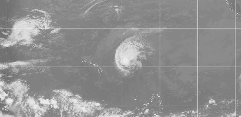
Composite satellite imagery valid July 28, 2026 03:30 UTC
FORECAST TRACK SUMMARY
Fausto is expected to maintain a general west-northwestward track over the coming days, steered by the mid- to low-level environmental flow. The storm should pass north of the main Hawaiian Islands Tuesday night into Wednesday. Full dissipation is forecast by Saturday, August 1.
INTENSITY FORECAST
Fausto is weakening and that trend is expected to continue. The storm is forecast to drop below tropical storm intensity by Wednesday and transition to a post-tropical remnant low by Thursday, as increasing wind shear and a very dry air mass erode the storm's organization.
IMPACTS & THREATS
The primary threat to the Hawaiian Islands is dangerous surf. Fausto-generated surf will continue to build westward along exposed east-facing shores through Tuesday as the storm approaches and begins to pass north of the islands. Large surf and strong rip currents will create hazardous conditions along exposed coastlines — mariners and beachgoers should consult their local National Weather Service office for the latest surf advisories. Significant rainfall and direct wind impacts are not currently forecast for the main Hawaiian Islands.
WIND PROBABILITY HIGHLIGHTS
There is an 11% cumulative chance of tropical-storm-force winds (34 kt / 39 mph) at Buoy 51101 during the period 0300 UTC Tuesday through 0000 UTC Friday. Nihoa carries a 3% cumulative probability of tropical-storm-force winds over the same five-day period.
WHAT TO WATCH
The key uncertainty is the pace of weakening — Fausto could transition to a post-tropical remnant low sooner than the current forecast indicates. Mariners operating north of the Hawaiian Islands should monitor subsequent advisories closely.
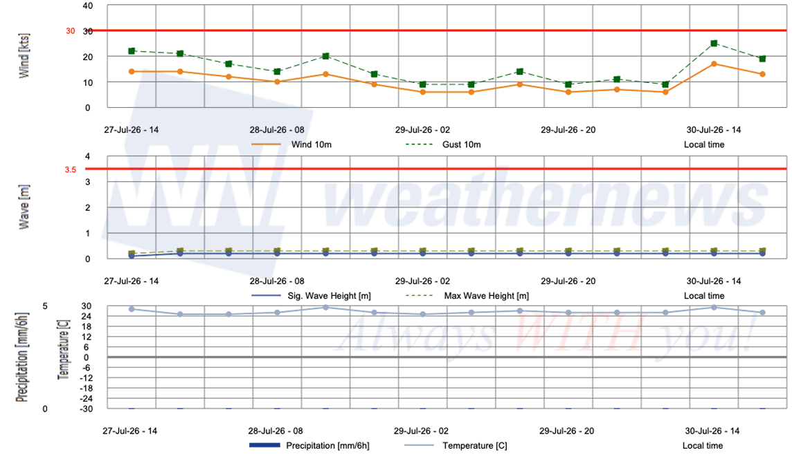
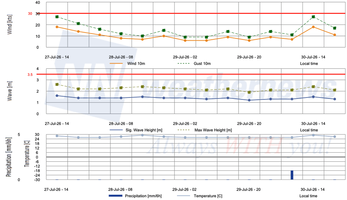
OPERATIONAL PORT FORECASTS
■HONOLULU, Hawaii, USA
■BARBERS POINT TERMINAL, Hawaii, USA
Weathernews Inc. assumes no liability for navigational decisions, losses, or damages resulting from reliance on this general overview.
While official observations guide the general threat assessment, highly detailed, proprietary routing and port forecasts are essential for safe navigation. Weathernews services provide customers with 24/7 localized data to ensure your vessels remain safe and well-informed. Please consult our dedicated services for the most up-to-date, detailed predictions for your specific routes and operations.
Note on the storm's name: Fausto is drawn from a pre-selected list of names maintained by the World Meteorological Organization (WMO) for Eastern North Pacific tropical cyclones. These names are ordinary personal names — chosen from languages commonly spoken around the basin, including English, Spanish, and French — selected for their ease of pronunciation and to ensure clear, unambiguous communication during emergencies. The same lists rotate on a fixed cycle, though names of particularly destructive or deadly storms are permanently retired and replaced. To learn more about how tropical cyclone names are selected, visit the National Hurricane Center.