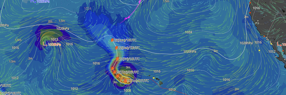
Hurricane Lala has strengthened and is forecast to become a major hurricane later today, according to the Central Pacific Hurricane Center (CPHC). Lala is turning toward the Papahanaumokuakea Marine National Monument, prompting a Hurricane Watch for its western atolls and a Tropical Storm Watch further east. No watches or warnings are in effect for the main Hawaiian Islands.
CURRENT STATUS
Based on the latest CPHC Public Advisory analysis on August 19, 2026, 00:00 UTC (2:00 PM HST, August 18):
As of 2:00 PM HST Tuesday (00:00 UTC Wednesday), the center of Hurricane Lala was located approximately 355 miles south-southeast of Maro Reef, moving west at 8 kt. Maximum sustained winds stood at 95 kt (110 mph) with gusts higher, and minimum central pressure was 966 mb. Hurricane-force winds extended outward up to 25 miles from the center, with tropical-storm-force winds reaching out to 105 miles.
A Hurricane Watch is in effect for the Papahanaumokuakea Marine National Monument from Lisianski Island to Maro Reef, and a Tropical Storm Watch is in effect east of Maro Reef to French Frigate Shoals.
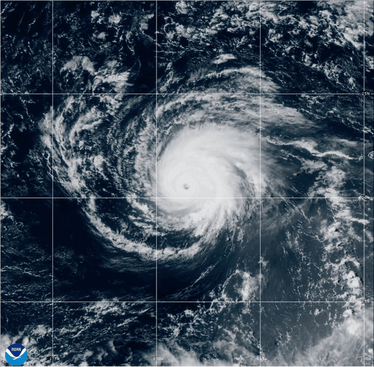
GOES Image Viewer (GeoColor) valid August 19, 2026 00:10 UTC
FORECAST TRACK SUMMARY
Lala is expected to continue moving west to west-northwest through Wednesday, then turn north Thursday as a weakening ridge and an approaching upper-level trough reshape the steering pattern. The system should curve back toward the northwest through the weekend as it rounds the eastern side of that trough. This track carries Lala toward the Papahanaumokuakea Marine National Monument, with the greatest impacts expected across its remote atolls rather than the main Hawaiian Islands.
INTENSITY FORECAST
Lala is forecast to reach major hurricane strength later today or tonight, with peak winds expected within the next day. Increasing wind shear and interaction with an upper-level trough should bring gradual weakening from Wednesday night through the weekend, with further weakening as the storm moves over cooler waters late in the forecast period.
IMPACTS & THREATS
- Winds: Hurricane conditions are possible in the Hurricane Watch area by Thursday, with tropical storm conditions possible as early as Wednesday night; tropical storm conditions are possible in the Tropical Storm Watch area by Thursday.
- Surf: Large surf associated with Lala will begin affecting the Papahanaumokuakea Marine National Monument early Wednesday, with waves likely to inundate low-lying atolls, especially from French Frigate Shoals to Maro Reef.
WIND PROBABILITY HIGHLIGHTS
Laysan Island faces the highest risk, with a 92% chance of tropical-storm-force winds, a 65% chance of 50-kt winds, and a 41% chance of hurricane-force winds through the weekend. Maro Reef follows closely, with an 80% chance of tropical-storm-force winds and a 22% chance of hurricane-force winds. Lisianski Island and areas further east carry lower but still meaningful chances of tropical-storm-force winds into the weekend.
WHAT TO WATCH / NEXT ADVISORY
The key uncertainty is the timing and sharpness of Lala's northward turn, which will determine how close the storm tracks to the Monument's atolls. Additional warnings for parts of the watch area are possible later today. The next complete advisory is due at 5:00 PM HST.
Advisories referenced are issued by the NWS Central Pacific Hurricane Center (CPHC) in coordination with the National Hurricane Center (NHC), a division of the National Oceanic and Atmospheric Administration (NOAA), providing official track, intensity, and hazard forecasts for tropical cyclones in the Central North Pacific basin.
Weathernews Inc. assumes no liability for navigational decisions, losses, or damages resulting from reliance on this general overview.
While official observations guide the general threat assessment, highly detailed, proprietary routing and port forecasts are essential for safe navigation. Weathernews services provide customers with 24/7 localized data to ensure your vessels remain safe and well-informed. Please consult our dedicated services for the most up-to-date, detailed predictions for your specific routes and operations.
Note on the storm's name: Lala is drawn from a pre-selected list of names maintained by the World Meteorological Organization (WMO) for Central North Pacific tropical cyclones. These names are ordinary personal names — chosen from languages commonly spoken around the basin, including English, Spanish, and French — selected for their ease of pronunciation and to ensure clear, unambiguous communication during emergencies. The same lists rotate on a fixed cycle, though names of particularly destructive or deadly storms are permanently retired and replaced. To learn more about how tropical cyclone names are selected, visit the National Hurricane Center.