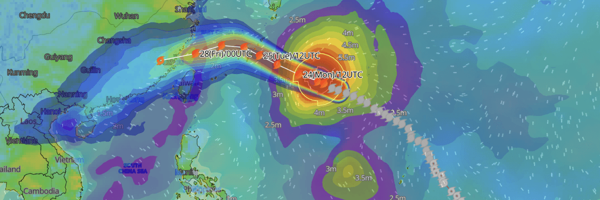
Typhoon No. 18 (Saudel), rated "very strong" by the Japan Meteorological Agency (JMA), is tracking west-northwest toward the Nansei Islands and is expected to approach the Okinawa and Amami regions with strong-to-very-strong intensity between 25 and 27 August, prompting warnings of violent winds, dangerously high waves, and heavy rainfall.
CURRENT STATUS
Based on the latest JMA observations on August 24, 2026 03:45 UTC
- Location: 24.2°N, 135.6°E — south of mainland Japan
- Intensity: Very strong typhoon
- Movement: West-northwest at 16 kt (30 km/h)
- Central pressure: 940 hPa
- Maximum sustained winds: 90 kt (167 km/h)
- Maximum gusts: 130 kt (241 km/h)
- Storm-force wind radius (25 m/s+): 90 NM (165 km), all quadrants
- Gale-force wind radius (15 m/s+): 210 NM (390 km) north / 180 NM (330 km) south
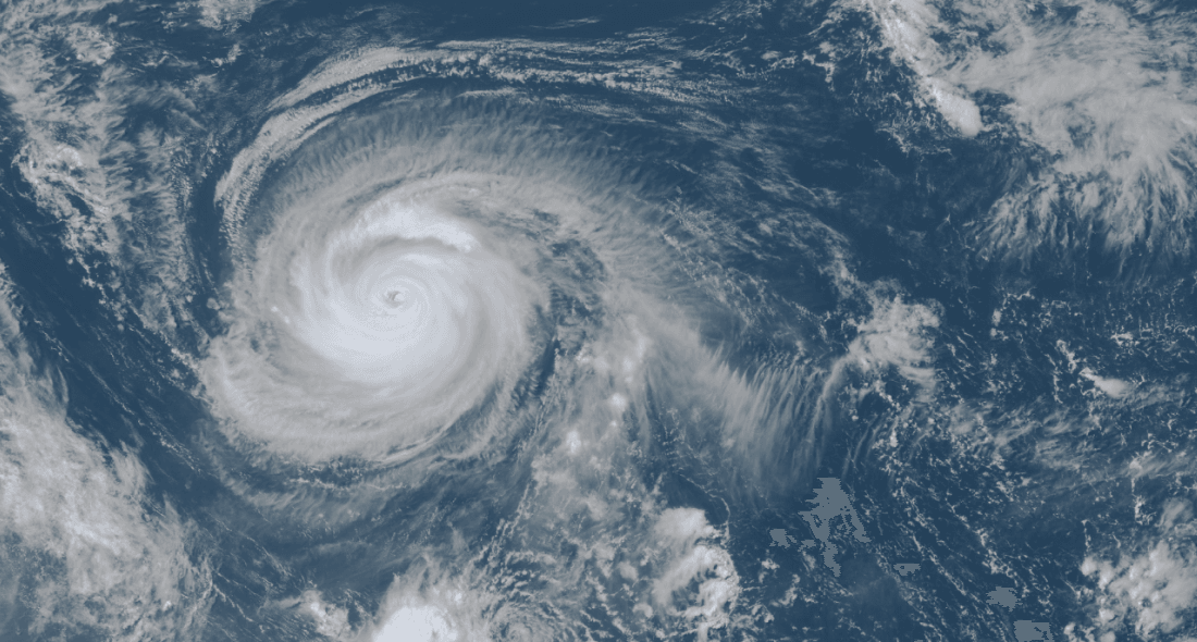
Himawari Satellite Image valid August 24, 2026 05:00 UTC
FORECAST TRACK SUMMARY
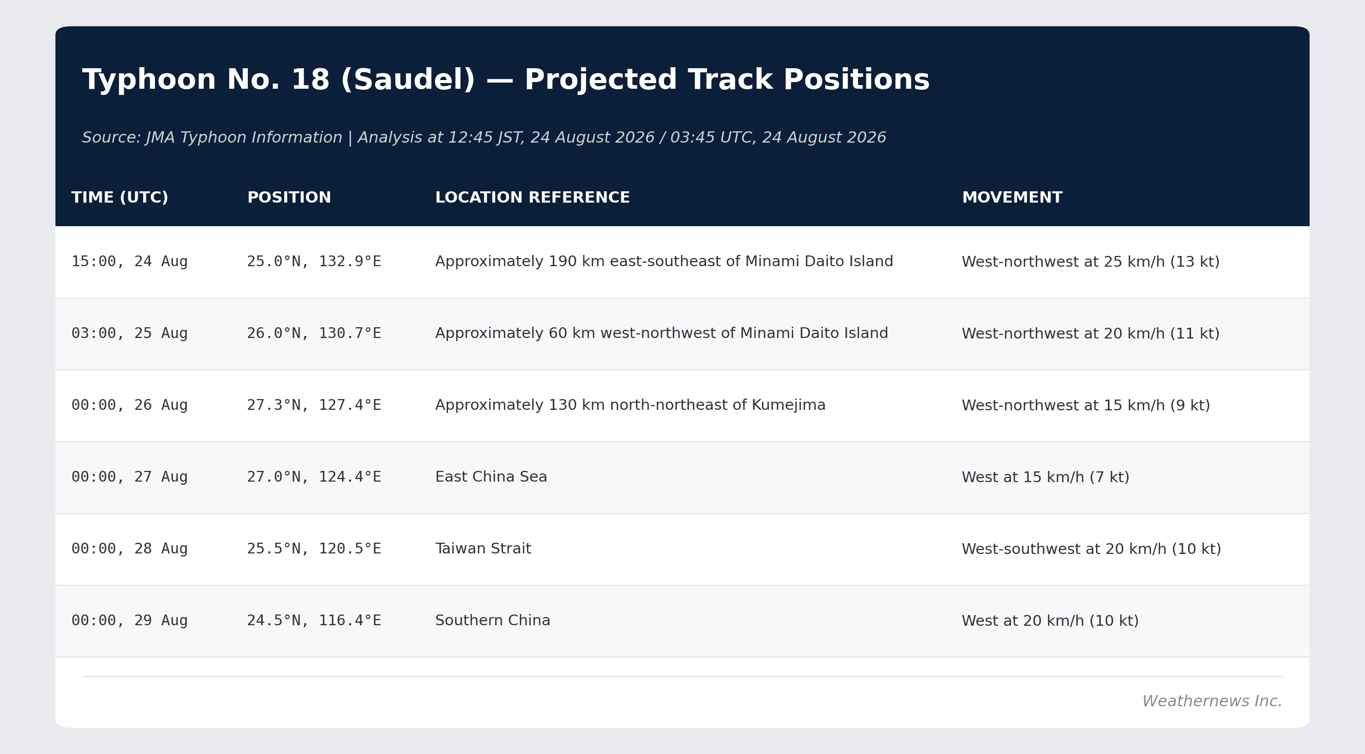
Typhoon No. 18 (Saudel) is forecast to track west-northwest toward the Nansei Islands, gradually slowing and curving west while weakening from "very strong" to "strong" as it nears Okinawa, Amami, and later the East China Sea and Taiwan Strait.
INTENSITY FORECAST
Central pressure is forecast to rise steadily from 940 hPa now to 950 hPa (25 Aug 12:00), 965 hPa (26 Aug 09:00), 970 hPa (27–28 Aug), and 996 hPa by 29 August, alongside maximum sustained winds easing from 90 kt to 35 kt (65 km/h) over the same period. The system is expected to remain very strong through 25 August, weaken to strong grade around 26 August as it nears the Nansei Islands, and continue weakening through the East China Sea and Taiwan Strait before nearing tropical storm strength by the time it reaches southern China.
IMPACTS & THREATS
Approaching the Okinawa and Amami regions before tracking into the East China Sea and Taiwan Strait, Typhoon No. 18 (Saudel) is forecast to bring violent winds, dangerous waves, and heavy rainfall across the Nansei Islands, with additional risk of landslides, flooding, river swelling, and storm surge.
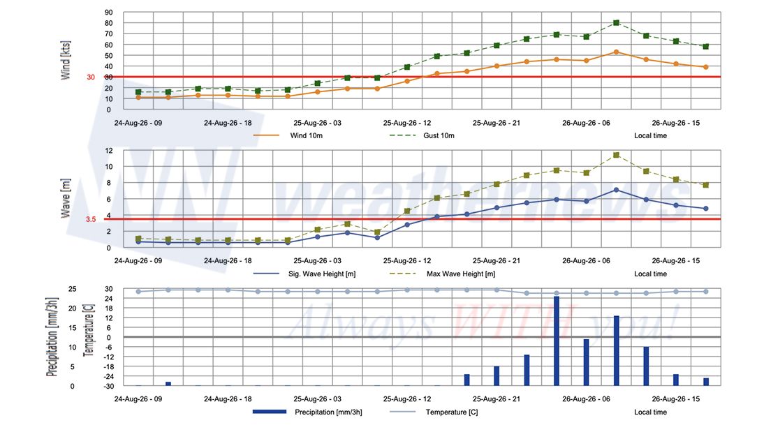
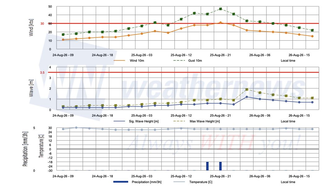
Violent Winds: From 24 August onward, conditions will deteriorate sharply across Okinawa. Maximum sustained winds of 23 m/s (35 m/s gusts) are forecast for the Okinawa region on 24 August, intensifying to 40 m/s sustained with gusts to 60 m/s on 25 August which are warned to be capable of partially collapsing homes. The Amami region faces maximum sustained winds of 35 m/s with gusts to 50 m/s on 25 August. Both Okinawa and Amami are forecast to see maximum sustained winds of 40 m/s with gusts to 55 m/s on 26 August as the typhoon nears the islands.
Dangerous Waves: Seas will build to extreme heights across Okinawa and Amami as the typhoon approaches. On 24 August, wave heights of 7 metres with swells are forecast for the Okinawa region. Conditions intensify sharply from 25 August, with waves reaching 11 metres with swells over Okinawa and 10 metres with swells over Amami—levels sustained through 26 August across both regions.
Heavy Rainfall: Very heavy rainfall is forecast across Amami and Okinawa as the typhoon nears the islands. In the 24 hours from 06:00 JST on 25 August to 06:00 JST on 26 August, accumulations are forecast to reach 150 mm over both Amami and Okinawa. In the following 24-hour period — from 06:00 JST on 26 August to 06:00 JST on 27 August — a further 150 mm is forecast over Okinawa, raising the risk of flash flooding, landslides, and river overflow across consecutive days.
Storm Surge and Coastal Flooding: Risk to low-lying coastal areas from storm surge as the typhoon nears Okinawa and Amami, compounding the threat from wind-driven high waves along exposed coastlines.
Landslides and Flooding: Strict vigilance for landslides, flooding of low-lying areas, and river swelling is advised across Okinawa and Amami as sustained heavy rainfall combines with already-saturated ground conditions ahead of the typhoon's closest approach.
OPERATIONAL PORT FORECASTS
The most acute operational risks are concentrated along the Okinawa and Amami coasts from 24 August through approximately 26 August, with hazards then extending into the East China Sea and Taiwan Strait as the storm tracks west-northwest before curving toward the Taiwan Strait and southern China.
■NAHA, Okinawa Islands, Japan
■NAZE, Amami Islands, Japan
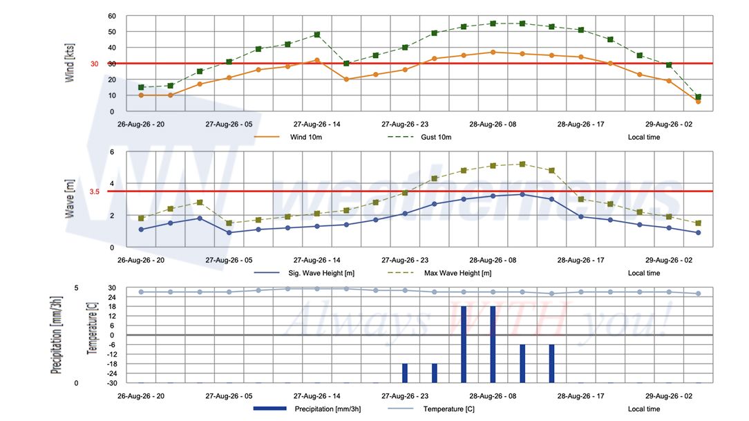
■TAIPEI, Taiwan
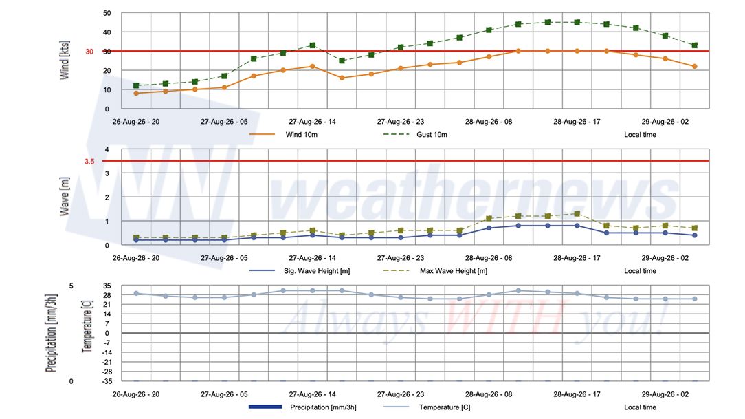
■WENZHOU, Zhejiang, China
Weathernews Inc. assumes no liability for navigational decisions, losses, or damages resulting from reliance on this general overview.
While official observations guide the general threat assessment, highly detailed, proprietary routing and port forecasts are essential for safe navigation. Weathernews services provide customers with 24/7 localized data to ensure your vessels remain safe and well-informed. Please consult our dedicated services for the most up-to-date, detailed predictions for your specific routes and operations.
Note on the storm's name: "Saudel" was contributed by the Federated States of Micronesia to the Western North Pacific and South China Sea tropical cyclone name list. In the Pohnpeian language, it refers to a trusted guard or soldier serving the Chief Saudeleur. The name replaced "Soudelor" after the 2015 storm caused significant damage in Taiwan and mainland China, leading to its retirement. The WMO and the ESCAP/WMO Typhoon Committee adopt these names sequentially to make tracking specific storms straightforward and to quickly communicate warnings. To learn more about how storms are named, please visit the World Meteorological Organization (WMO) website.