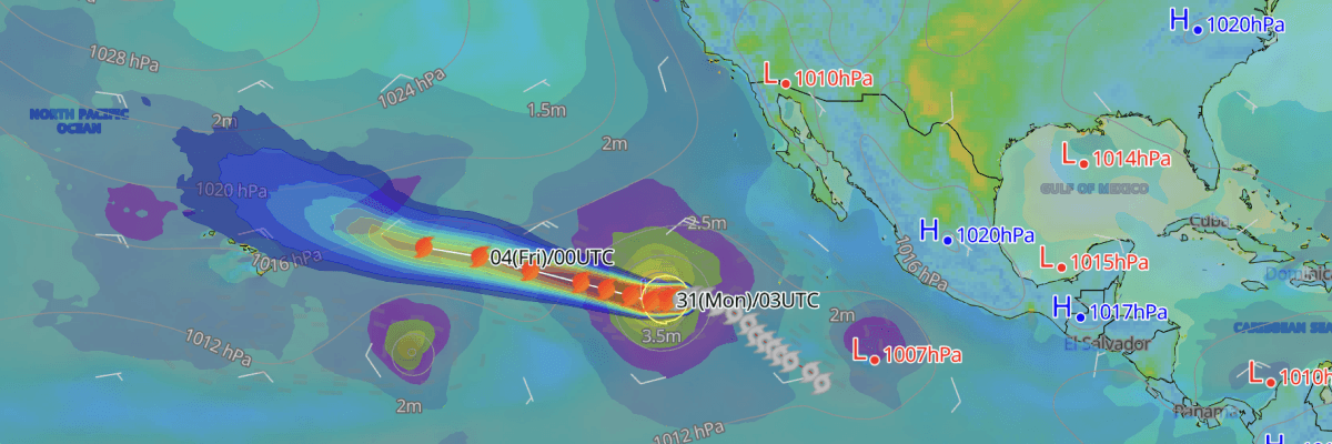
Major Hurricane Karina—now a major hurricane at Category 3 strength, is tracking steadily westward across the open eastern Pacific well south of Mexico, with a turn toward the west-northwest expected the night of August 31 into September 1 as the system continues to strengthen. Life-threatening surf and rip currents are forecast along the southwest Mexico coast and the Baja California Peninsula through September 2–3 as swells generated by the hurricane reach the shoreline, according to the National Hurricane Center (NHC).
CURRENT STATUS
Based on the latest NHC Public Advisory analysis on August 31, 2026 03:00 UTC
- Location: 17.1°N, 123.8°W—approximately 1,585 km (985 mi) west-southwest of the southern tip of Baja California
- Intensity: Major Hurricane, Category 3
- Movement: West at 15 km/h (8 kt)
- Central pressure: 954 mb
- Maximum sustained winds: 205 km/h (110 kt)
- Gusts: 250 km/h (135 kt)
- Hurricane-force winds (64 kt) radius: up to 65 km (40 mi) from centre
- Tropical-storm-force winds (34 kt) radius: up to 205 km (125 mi) from centre
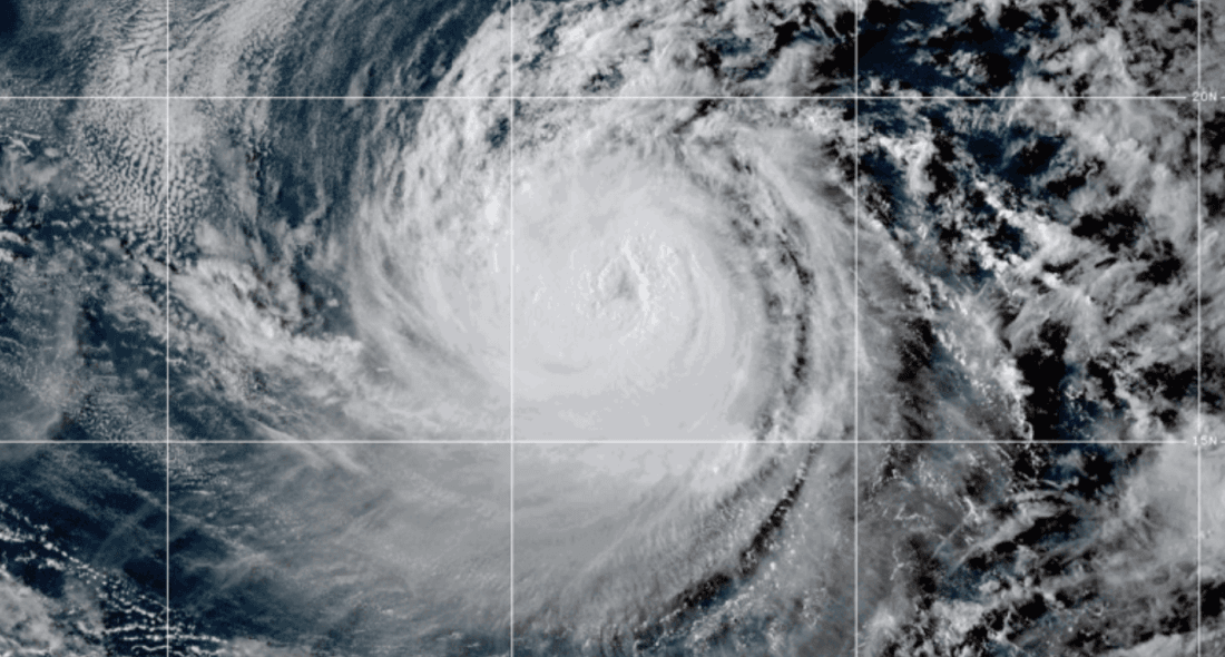
GOES Image Viewer (GeoColor) valid 31 August, 2026 01:00 UTC
FORECAST TRACK SUMMARY
Major Hurricane Karina is expected to continue tracking westward through August 31 before turning west-northwest the night of August 31 into September 1, staying well away from the Mexican coast and Baja California Peninsula throughout the forecast period. The storm's path may also influence the track of Tropical Storm Lowell as the two systems move through the central Pacific in the coming days.
INTENSITY FORECAST
Major Hurricane Karina may strengthen further through September 1 due to favorable environmental conditions. A gradual weakening trend will then follow as the storm moves over cooler waters and drier air, with sustained winds dropping to approximately 75 knots (85 mph) by September 5.
IMPACTS & THREATS
Tracking westward across the open Eastern North Pacific before turning west-northwest overnight into September 1, Major Hurricane Karina presents hazards for maritime operations across a wide area while generating swells affecting the coastlines of southwest Mexico and the Baja California Peninsula.
Surf: Swells generated by Major Hurricane Karina are currently affecting the coasts of southwest Mexico and the Baja California Peninsula, likely to cause life-threatening surf and rip current conditions over the next couple of days.
Waves: Significant wave heights of 4 metres or greater extend up to 300 NM (556 km) to the northeast, 270 NM (500 km) to the northwest, and around 210 NM (389 km) to the southeast and southwest of Karina's centre, posing a significant hazard for vessels operating in the Eastern North Pacific in the vicinity of the storm.
Winds: Winds of 64 kt (119 km/h) or greater currently extend up to 35 NM (65 km) to the northeast and northwest, and 25–30 NM (46–56 km) to the southwest and southeast of the storm's centre. The 50-kt (93 km/h) wind field extends up to 60 NM (111 km) to the northeast and northwest, and 40–50 NM (74–93 km) to the southwest and southeast. The 34-kt (63 km/h) wind field extends up to 110 NM (204 km) in all quadrants, its widest and most uniform extent. As Karina weakens later in the week, the wind field is forecast to gradually contract.
Advisories referenced are issued by the National Hurricane Center (NHC), a division of the National Oceanic and Atmospheric Administration (NOAA), providing official track, intensity, and hazard forecasts for tropical cyclones in the Atlantic and Eastern Pacific basins.
Weathernews Inc. assumes no liability for navigational decisions, losses, or damages resulting from reliance on this general overview.
While official observations guide the general threat assessment, highly detailed, proprietary routing and port forecasts are essential for safe navigation. Weathernews services provide customers with 24/7 localized data to ensure your vessels remain safe and well-informed. Please consult our dedicated services for the most up-to-date, detailed predictions for your specific routes and operations.
Note on the storm's name: "Karina" is drawn from the 2026 Eastern North Pacific tropical cyclone name list, the eleventh name in the season's sequence. Eastern North Pacific tropical cyclone names are pre-selected from six rotating lists. To learn more about how storms are named, please visit the World Meteorological Organization (WMO) website.