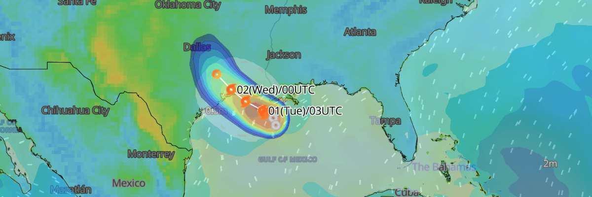
Tropical Storm Edouard is strengthening as it tracks toward the northwestern Gulf of Mexico coast of the United States, with landfall expected later on September 1, 2026 along the Texas–Louisiana state border. Maximum sustained winds are near 35 kt (40 mph), and Tropical Storm Edouard could approach hurricane strength before moving ashore. A Hurricane Watch, Storm Surge Warning, and Tropical Storm Warning are in effect for parts of southeast Texas and southwest Louisiana, USA.
CURRENT STATUS
Based on the latest NHC Public Advisory analysis on September 1, 2026 06:00 UTC
- Location: 28.8°N, 92.5°W — approximately 135 km (85 mi) southeast of Cameron, Louisiana and 185 km (115 mi) southeast of Port Arthur, Texas
- Intensity: Tropical Storm
- Movement: West-northwest at 11 km/h (6 kt)
- Central pressure: 1005 mb
- Maximum sustained winds: 65 km/h (35 kt)
- Maximum Gusts: 85 km/h (45 kt)
- Tropical-storm-force winds (34 kt) radius: up to 35 km (25 mi) from centre
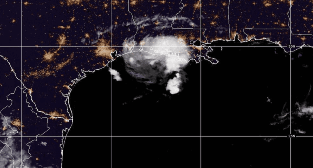
GOES Image Viewer (GeoColor) valid 1 September, 2026 06:40 UTC
FORECAST TRACK SUMMARY
Tropical storm Edouard is forecast to continue on a west-northwestward to northwestward track over the next day or two, steered by a ridge of high pressure over the southeastern United States. On this track, the center is expected to reach the Gulf Coast within the warning area later on September 1, then move inland over southeast Texas overnight into September 2. The storm is expected to weaken rapidly and dissipate over land by early September 3.
INTENSITY FORECAST
Additional strengthening is forecasted as tropical storm Edouard moves over very warm waters of the northwestern Gulf of Mexico, within a low-shear and sufficiently moist environment, through the morning of September 1. Given the storm's small size, forecasters note that a period of quick organization and strengthening is possible, and Edouard could near hurricane strength as it approaches the coast later that day. Because peak intensity is expected to occur near the time of landfall, rapid weakening is expected once the center moves inland.
IMPACTS & THREATS
Storm Surge: Surge of 1-1.5 m (3-5 ft) above ground is possible from High Island, Texas, to the Vermilion/Cameron Parish line in Louisiana, with 1 to 3 feet (0.3 to 1 m) farther east toward Morgan City, Louisiana.. There is also potential for major beach erosion, heavy surf breaching dunes, and strong, numerous rip currents along the immediate coast.
Rainfall: Tropical storm Edouard is expected to produce 75–150 mm (3-6 in) of rain, with isolated totals up to 9 inches (230 mm), across the Upper Texas coast and inland into east-central Texas through September 2, raising the risk of flash flooding and possible river flooding. Far southwest Louisiana may see 2 to 3 inches (50–75 mm).
Winds: Tropical-storm-force winds of 34 kt (63 km/h) currently extend up to 35 km (25 mi) from the center. Wind probability data show Cameron, Louisiana carrying the highest risk, with roughly a 62% cumulative chance of tropical-storm-force winds by the morning of September 2, while Port Arthur and High Island, Texas both carry cumulative probabilities above 20% through the same period. No significant probability of hurricane-force winds is forecast for any location.
Waves: Significant wave heights of 4 metres or greater currently extend up to 56 km (30 NM) to the northeast of Edouard's centre, with no comparable wave field extending in other quadrants at this time, posing a localized hazard for vessels operating northeast of the storm in the Gulf of Mexico.
Tornadoes: There are little to no tornado impacts anticipated at this time.
OPERATIONAL PORT FORECASTS
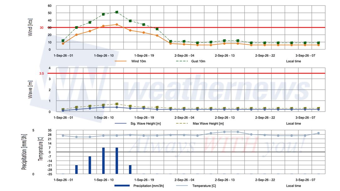
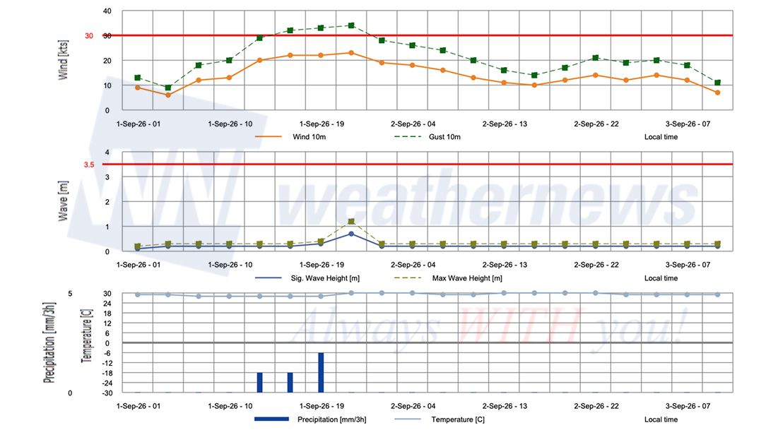
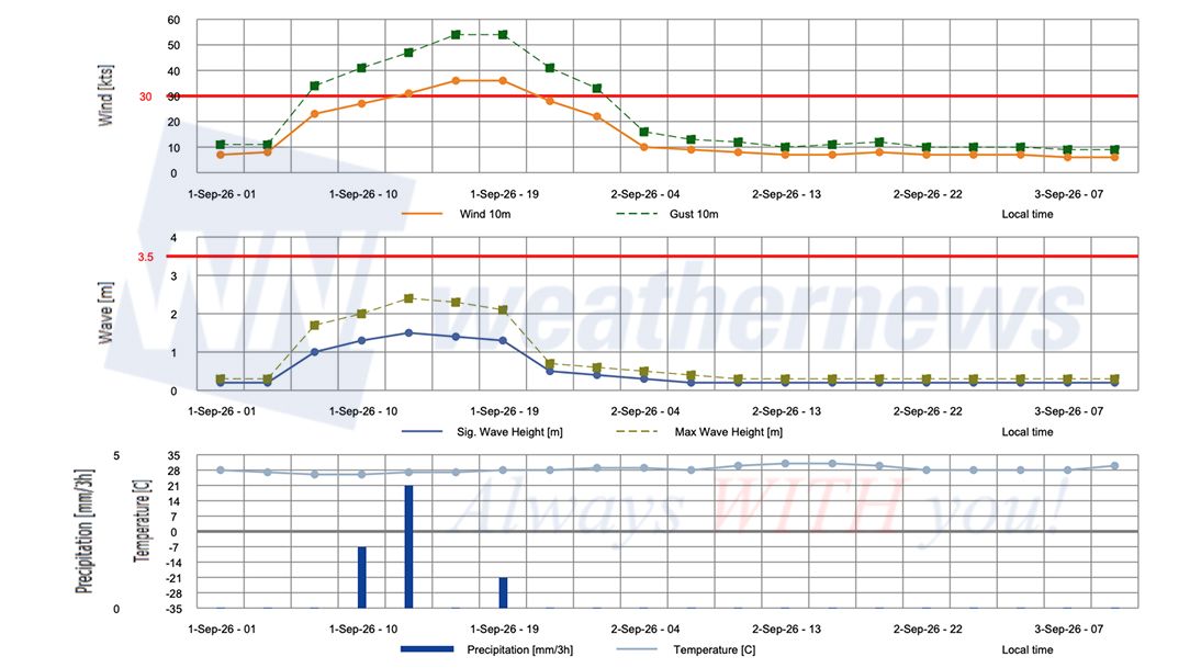
The operational risks vary by location and timing across Edouard's track through the northwestern Gulf of Mexico. The area from High Island to Cameron, Louisiana faces the most immediate and severe exposure, sitting within both the Hurricane Watch and the Storm Surge Warning zone, with the highest tropical-storm-force wind probability in the advisory package (roughly 62% cumulative by the morning of September 2).
■CAMERON, Louisiana, United States
■GALVESTON, Texas, United States
■PORT ARTHUR, Texas, United States
Advisories referenced are issued by the National Hurricane Center (NHC), a division of the National Oceanic and Atmospheric Administration (NOAA), providing official track, intensity, and hazard forecasts for tropical cyclones in the Atlantic and Eastern Pacific basins.
Weathernews Inc. assumes no liability for navigational decisions, losses, or damages resulting from reliance on this general overview.
While official observations guide the general threat assessment, highly detailed, proprietary routing and port forecasts are essential for safe navigation. Weathernews services provide customers with 24/7 localized data to ensure your vessels remain safe and well-informed. Please consult our dedicated services for the most up-to-date, detailed predictions for your specific routes and operations.
Note on the storm's name: "Edouard" is drawn from the 2026 North Atlantic tropical cyclone name list, the fifth name in the season's sequence. Eastern North Pacific tropical cyclone names are pre-selected from six rotating lists. To learn more about how storms are named, please visit the World Meteorological Organization (WMO) website.