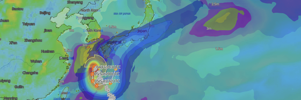
Tropical Storm No. 24 (Krovanh) is tracking slowly north-northwestward through the northern East China Sea approximately 160 km west-northwest of Amami City. The cyclone is forecast to decelerate sharply and execute an unusual southward-to-eastward loop near the Nansei (Ryukyu) Islands through 8 September. Concurrently, a stationary front stalled along the southern coast of Honshu is drawing abundant, warm tropical moisture northward along the storm’s eastern flank, triggering extreme atmospheric instability and prolonged downpours across western, eastern, and northern Japan.
CURRENT STATUS
Based on the latest JMA observations on September 4, 2026 03:45 UTC
- Location: 29.8°N, 127.9°E — approximately 160 km west-northwest of Amami City, East China Sea
- Classification: Tropical Storm (no size or intensity designation)
- Movement: North-northwest at 6 kt (10 km/h)
- Central pressure: 992 hPa
- Maximum sustained winds: 35 kt (65 km/h)
- Maximum gusts: 50 kt (93 km/h / 25 m/s)
- ≥30-kt wind area: 390 km (210 NM) northeast, 280 km (150 NM) southwest
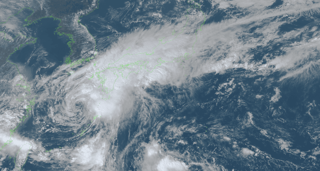
Himawari Satellite Imagery (Visible Color) valid September 4, 2026 04:50 UTC
FORECAST TRACK SUMMARY
Tropical Storm No. 24 (Krovanh) is projected to stall and reverse direction over the coming days, curving south-southwestward toward waters west of Amami by 5 September, before tracking southward just east of Okinawa on 6 September. Between 7 and 8 September, the system is expected to curve east-northeastward toward the Daito Islands and drift north toward waters south of Shikoku and Honshu, weakening to a Tropical Depression by 8 September.
INTENSITY FORECAST
Tropical Storm No. 24 (Krovanh) is forecast to maintain sustained winds of 35 kt (65 km/h) with gusts to 50 kt (93 km/h) and a central barometric pressure of 994 hPa through 7 September. As the system moves into open waters south of Honshu on 8 September, it is forecast to weaken to a Tropical Depression (TD) with a central pressure rising to 998 hPa.
A frontal boundary will remain stalled near the Pacific coast of Honshu through 6 September. Deep tropical moisture feeding into this boundary creates an imminent risk of linear precipitation bands developing over Shikoku, northern Kyushu (including Yamaguchi Prefecture), southern Kyushu, and Amami, which could trigger a sudden and severe escalation of flood and landslide disasters.
IMPACTS & THREATS
Lingering across the East China Sea and Nansei Islands while interacting with a stalled frontal boundary along Honshu, Tropical Storm No. 24 (Krovanh) presents immediate hazards of torrential rain, violent squalls, and dangerous seas across the southwestern islands and mainland Japan through at least 6–8 September.
Strong Winds: Strong winds are forecast across the Nansei Islands and southern Kyushu through 6 September. The Amami region faces maximum sustained winds of 35 kt (65 km/h / 18 m/s) with gusts up to 60 kt (110 km/h / 30 m/s). The Okinawa region faces sustained winds of 33 kt (61 km/h / 17 m/s) with gusts to 50 kt (90 km/h / 25 m/s). Southern Kyushu is forecast to see sustained winds of 30 kt (54 km/h / 15 m/s) with gusts up to 50 kt (90 km/h / 25 m/s).
Dangerous Waves: High seas and swells will affect waters across the Nansei Islands and southern Kyushu through 6 September. The Amami region faces wave heights of 5 metres with swells, while wave heights of 4 metres with swells are forecast for both the Okinawa region and southern Kyushu.
Heavy Rainfall: Torrential rainfall will impact western and eastern Japan, with localized totals escalating sharply where linear precipitation bands establish. In the 24 hours from 21:00 UTC on 3 September (06:00 JST, 4 Sep) to 21:00 UTC on 4 September, accumulations are forecast to reach 300 mm in Shikoku; 250 mm in southern Kyushu; 200 mm in northern Kyushu and Amami; 150 mm in Kinki; and 80 mm in Kanto-Koshin, Tokai, and Chugoku. In the following 24-hour period (to 21:00 UTC on 5 September), rainfall is forecast to reach 150 mm in Kinki, Shikoku, and southern Kyushu; 120 mm in Tokai, northern Kyushu, and Amami; 100 mm in Kanto-Koshin and the Izu Islands; and 80 mm in Okinawa. From 21:00 UTC on 5 September to 21:00 UTC on 6 September, a further 200 mm is forecast across Tokai and Shikoku; 150 mm across Kanto-Koshin, Kinki, and the Izu Islands; 100 mm in southern Kyushu; and 80 mm in northern Kyushu.
Landslides and Flooding: Strict vigilance is required across Western Japan through 5 September for landslides, inundation of low-lying areas, and river swelling or overflow. Vigilance for landslides and flooding extends across northern Japan on 4 September, and across the Nansei Islands, Western Japan, and Eastern Japan through 6 September, especially where ground saturation is already elevated from prior rains.
Severe Convective Weather: Severe thunderstorms, lightning strikes, tornadoes, intense localized downpours, and hail remain significant threats near convective cells and the frontal boundary.
OPERATIONAL PORT FORECAST
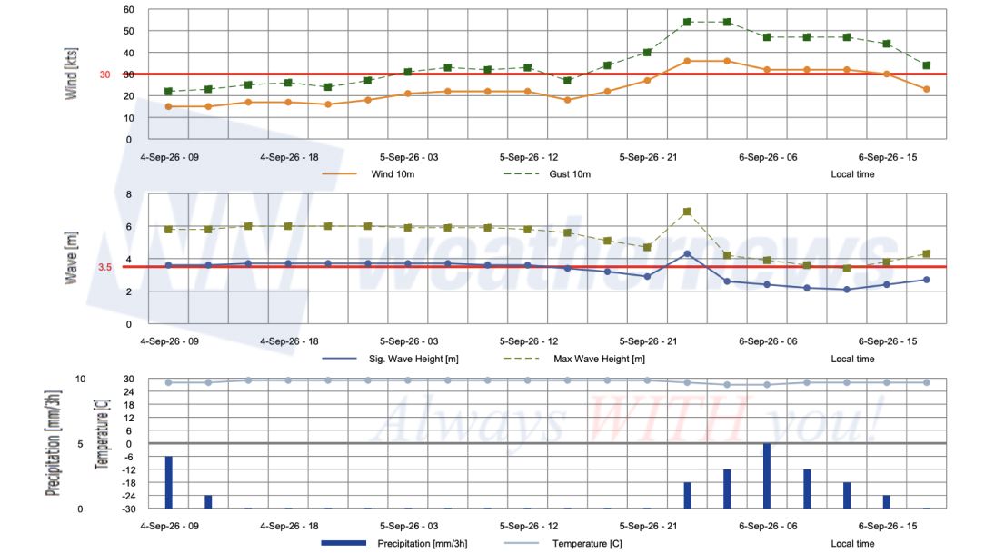
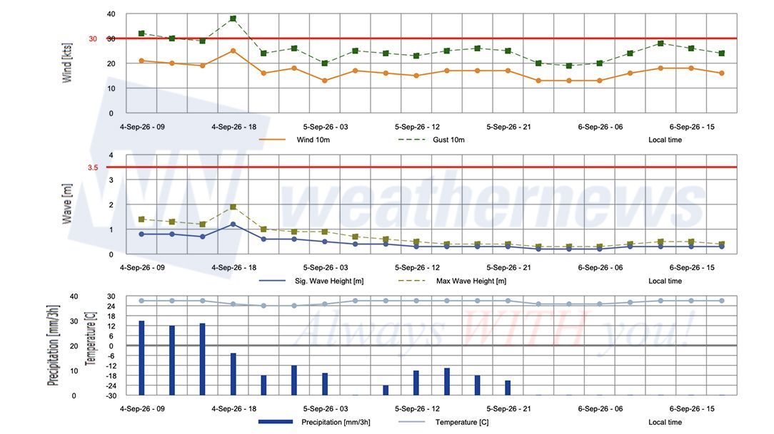
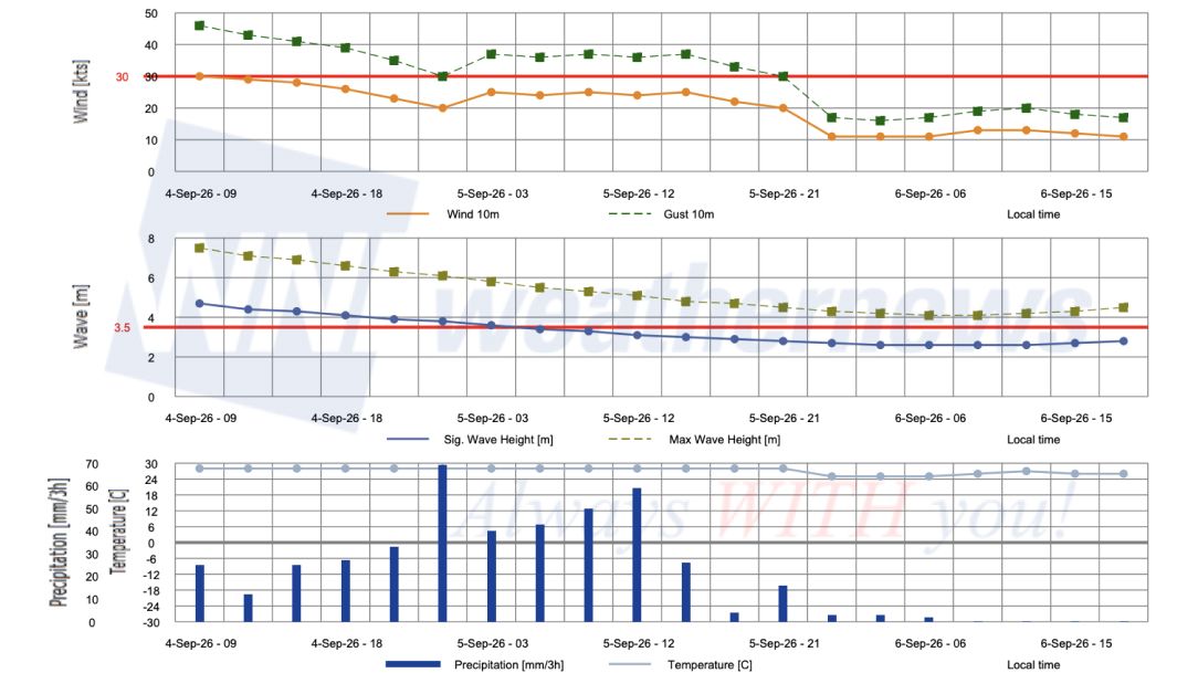
Operational risks remain severe across ports in the Amami and Okinawa regions through 6 September, with heavy sea and swell hazards extending into the northern East China Sea, the Tokara/Osumi straits, and coastal waters of southern Kyushu and Shikoku.
■NAHA, Okinawa Islands, Japan
■KAGOSHIMA, Kagoshima, Japan
■ANBOU, YAKUSHIMA, Kagoshima, Japan
Weathernews Inc. assumes no liability for navigational decisions, losses, or damages resulting from reliance on this general overview.
While official observations guide the general threat assessment, highly detailed, proprietary routing and port forecasts are essential for safe navigation. Weathernews services provide customers with 24/7 localized data to ensure your vessels remain safe and well-informed. Please consult our dedicated services for the most up-to-date, detailed predictions for your specific routes and operations.
Note on the storm's name: "Krovanh" is drawn from the Western North Pacific and South China Sea tropical cyclone name list, contributed by Cambodia, and refers to a cardamom tree (wild cardamom). The WMO and the ESCAP/WMO Typhoon Committee adopt these names sequentially to make tracking specific storms straightforward and to quickly communicate warnings. To learn more about how storms are named, please visit the World Meteorological Organization (WMO) website.