About This Outlook
As part of our ongoing commitment to protect mariners' lives and help in times of crisis, Weathernews will be providing daily snapshots of critical port weather trends in the Indian Ocean.
Explore this week’s operational weather risks in our [Weekly Outlook].
Reports are updated four times daily and include 48-hour, 5-day and 7-day outlooks for your use.
Daily Port Weather Highlights
This snapshot is based on the 48-hour forecast issued September 15, 2026, at 00:00 UTC.
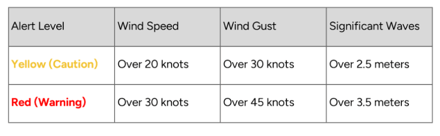
Port Forecast Alert Threshold
■ KAWTHAUNG, Myanmar
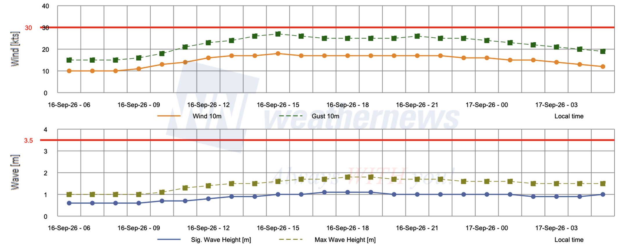
Moderate winds and calm seas persist throughout September 16, with all parameters remaining safely below cautionary thresholds.
Wind: Winds start at 10 kts at 05:00 LT, building slightly to a peak of 11 kts between 06:00–14:00 LT, then easing to 8 kts by 21:00–23:00 LT.
Gust: Gusts hold at 15 kts at 05:00 LT, climbing to a peak of 17 kts at 12:00–14:00 and again at 18:00 LT, before dropping to 13 kts between 20:00–22:00 LT.
Wave: Significant wave height starts at 2.5 m at 05:00 LT, holding at that level through 12:00 LT, then gradually declining to 2.2 m by 19:00–23:00 LT.
■ HAMBANTOTA, Sri Lanka

Gentle conditions prevail across September 16, with winds, gusts, and wave heights showing minor daytime fluctuations while staying well below cautionary levels.
Wind: Winds range between 9–14 kts, peaking at 14 kts from 14:00–17:00 LT before easing to a low of 9 kts by 22:00–23:00 LT.
Gust: Gusts increase to 21 kts between 13:00–17:00 LT before diminishing to 13 kts by late evening.
Wave: Significant wave height remains exceptionally stable between 2.1–2.2 m throughout the entire day.
■ TOAMASINA (TAMATAVE), Madagascar

Winds and gusts ease steadily throughout September 16, while hazardous sea conditions persist with significant wave heights exceeding Red Warning levels across most of the day before tapering slightly by late evening.
Wind: Winds begin at a peak of 17 kts at 03:00 LT, easing progressively through the afternoon to a low of 9 kts by 23:00 LT.
Gust: Gusts decrease from a high of 25 kts at 03:00 LT to reach 13 kts by 23:00 LT, staying well below caution criteria.
Wave: Significant wave height starts at 3.7 m at 03:00 LT, peaks at 3.8 m from 09:00–13:00 LT, and eases to 3.5 m by 22:00–23:00 LT, remaining above the 2.5 m Yellow Caution threshold throughout the entire period and exceeding the 3.5 m Red Warning threshold from 03:00–21:00 LT.
View Detailed Forecasts on SeaNavigator Free
Disclaimer: This outlook is provided for informational purposes only; our actionable, ship-specific advisories are exclusively available through our paid maritime solutions. Weathernews Inc. assumes no liability for navigational decisions, losses, or damages resulting from reliance on this general overview.
Major Ports with Published Port Forecasts
Arabian Sea Coast Region
- India: Mumbai Port, Nhava Sheva (Jawaharlal Nehru Port)
- Pakistan: Karachi Port, Gwadar, Muhammad Bin Qasim
- Qatar: Doha Port, Ras Laffan Port
- Oman: Salalah, Duqm
- Yemen: Aden
In addition, approximately 150 locations are covered, including ports in the Persian Gulf and the Red Sea.