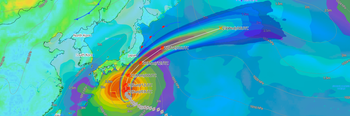
Typhoon No. 25 (Dujuan), a large and strong typhoon currently tracking north of the Philippine Sea, is forecast to pass close to Japan's Kanto-Koshin region from midday Monday, September 21, through late that night, bringing torrential rain, violent winds, and rough seas to Japan's eastern Pacific coast before weakening into an extratropical low well east of Hokkaido by September 23, according to the Japan Meteorological Agency (JMA).
CURRENT STATUS
Based on the latest JMA observations on September 20, 2026 03:45 UTC
- Location: 29.2°N, 137.5°E, south of mainland Japan
- Intensity: Typhoon (large scale)
- Movement: NNW at 6 kt (10 km/h)
- Central pressure: 970 hPa
- Maximum sustained winds: 65 kt (120 km/h), with gusts to 95 kt (176 km/h)
- Radius of 50-kt winds: 60 NM (110 km); radius of 30-kt winds: 425 NM (800 km) to the northeast, 240 NM (440 km) to the southwest
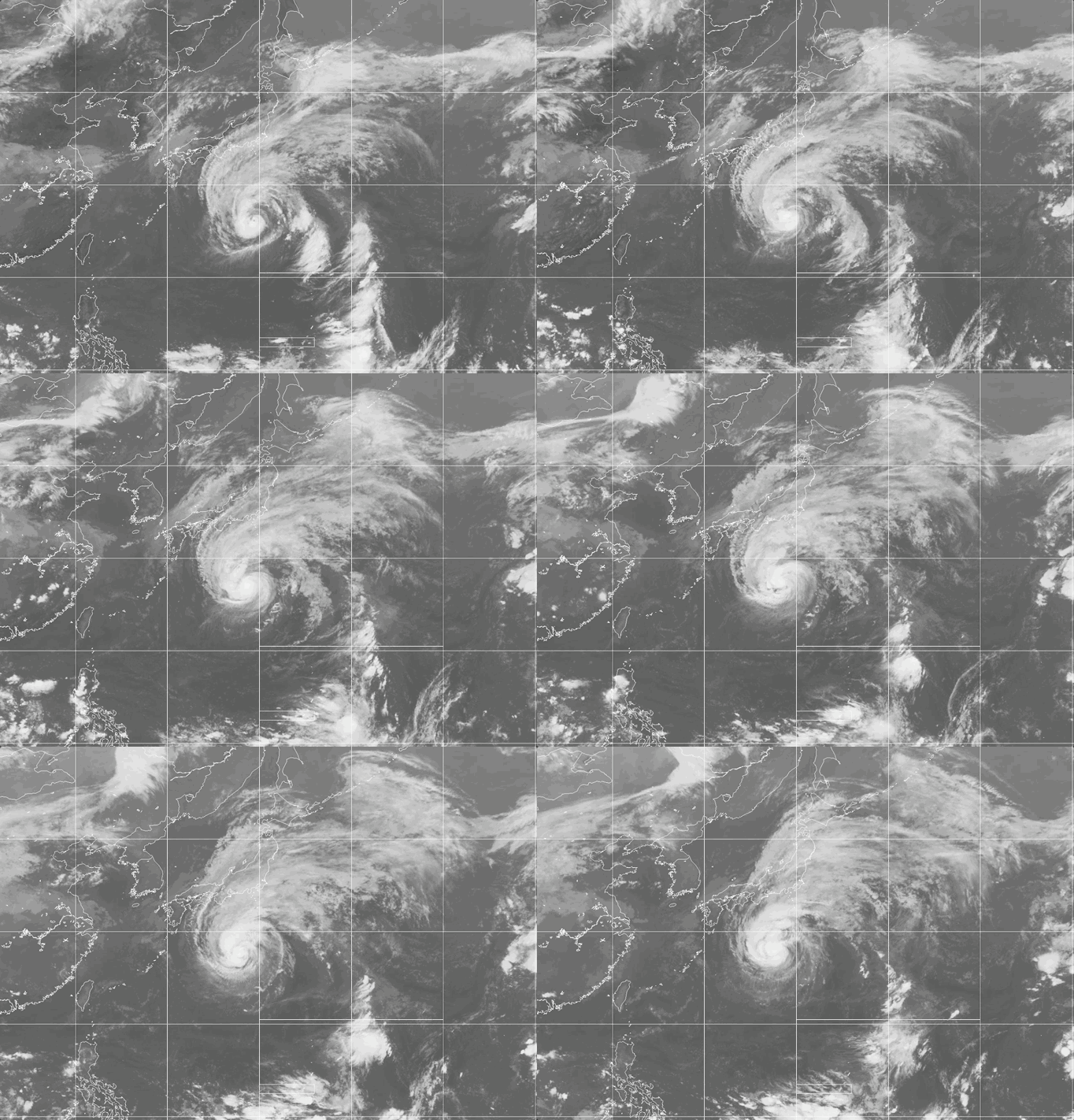
Weathernews Global Composite Satellite Imagery valid September 19, 2026 03:30 UTC to September 20, 2026 03:30 UTC
FORECAST TRACK SUMMARY
JMA's forecast has Dujuan continuing north-northwest overnight, reaching 30.8°N, 137.4°E by 00:00 JST September 21, before curving toward the north and then northeast. By 12:00 JST September 21 the storm's center is forecast near 32.8°N, 138.5°E, still at typhoon intensity, as it makes its closest approach to the Kanto-Koshin region through the afternoon and into the night. The system is then expected to accelerate northeastward, reaching 37.8°N, 146.0°E by 09:00 JST September 22 — off the Tohoku Pacific coast — while remaining a typhoon. By 09:00 JST September 23, JMA forecasts the center near 42.6°N, 161.6°E, well east of Hokkaido, with the system having transitioned to an extratropical low.
INTENSITY FORECAST
Dujuan is expected to hold steady or intensify slightly through its approach to Japan: central pressure is forecast to deepen from 970 hPa to 965 hPa between the September 20 analysis and the September 21 forecast, with maximum sustained winds increasing from 65 kt (120 km/h) to 70 kt (130 km/h) and gusts up to 100 kt (185 km/h). The typhoon is forecast to maintain this intensity as it passes the Tohoku Pacific coast on September 22 before weakening as it transitions to an extratropical low by September 23, with maximum winds dropping to 50 kt (93 km/h) and gusts to 70 kt (130 km/h).
IMPACTS & THREATS
According to JMA's general meteorological outlook issued at 11:00 JST September 20, heavy rain is expected across eastern Japan and the Tohoku Pacific coast as Dujuan approaches, with thunderstorms and locally very heavy rainfall possible. Because of the storm's large size, intense rain may begin well before the center's closest approach, raising total rainfall. Forecast 24-hour rainfall totals from 12:00 JST September 20 to 12:00 JST September 21 include up to 300 mm in the Izu Islands and Tokai region, 200 mm in Kanto, and 80 mm in Tohoku; from 12:00 JST September 21 to 12:00 JST September 22, totals of up to 300 mm are possible in Kanto, the Izu Islands, and Tokai, and up to 200 mm in Tohoku.
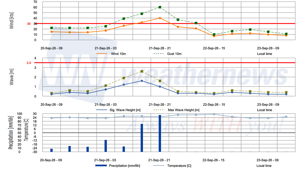
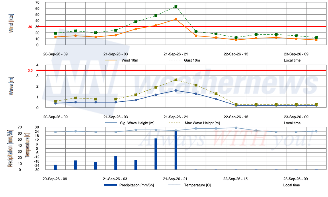
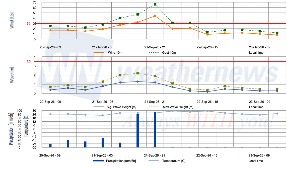
Violent winds are expected in Kanto and the Izu Islands, with maximum sustained winds on September 21 forecast to reach 35 m/s (68 kt) with gusts to 50 m/s (97 kt) in both areas, and 25 m/s (49 kt) with gusts to 35 m/s (68 kt) in Tokai. JMA warns that some utility poles could topple and building materials could scatter over a wide area in Kanto-Koshin, and is urging residents to avoid unnecessary outings and stay away from windows.
Seas will build with swell across the Izu Islands and Japan's eastern Pacific coast, with wave heights forecast to reach 9 meters in the Izu Islands and 8 meters in Kanto on September 21. JMA has issued strict warnings for landslides, flooding of low-lying areas, and river swelling or overflow across the eastern Pacific side of Japan through September 22, and across Tohoku from September 21 to 22. Lightning, sudden gusts, hail, and isolated tornadoes are also possible.
OPERATIONAL PORT FORECASTS
■ TOKYO, Tokyo, Japan
■ CHIBA, Chiba, Japan
■ YOKOHAMA, Kanagawa, Japan
Weathernews Inc. assumes no liability for navigational decisions, losses, or damages resulting from reliance on this general overview.
While official observations guide the general threat assessment, highly detailed, proprietary routing and port forecasts are essential for safe navigation. Weathernews services provide customers with 24/7 localized data to ensure your vessels remain safe and well-informed. Please consult our dedicated services for the most up-to-date, detailed predictions for your specific routes and operations.
Note on the storm's name: "Dujuan" is drawn from the Western North Pacific and South China Sea tropical cyclone name list, contributed by China, and refers to the azalea flower. The WMO and the ESCAP/WMO Typhoon Committee adopt these names sequentially to make tracking specific storms straightforward and to quickly communicate warnings. To learn more about how storms are named, please visit the World Meteorological Organization (WMO) website.