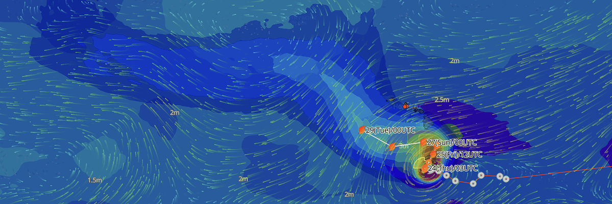
Tropical Storm Nolo is moving slowly over the Central North Pacific south of the Hawaiian Islands. The cyclone currently carries maximum sustained winds of 75 km/h (40 kt / 45 mph) and a minimum central pressure of 1002 mb (1002 hPa). A Hurricane Watch remains in effect for Hawaii County as the system is forecast to strengthen into a hurricane by Thursday night and approach major hurricane intensity as it passes south of the Big Island on Saturday.
CURRENT STATUS
Based on the latest CPHC/NHC Public Advisory analysis on September 24, 2026 03:00 UTC
- Location: 14.7°N, 155.9°W — approximately 480 km (295 mi) south of South Point, Hawaii and 765 km (475 mi) south-southeast of Honolulu, Hawaii
- Intensity: Tropical Storm
- Movement: West-northwest at 9 km/h (5 kt)
- Central pressure: 1002 mb (1002 hPa)
- Maximum sustained winds: 75 km/h (40 kt / 45 mph)
- Maximum gusts: 95 km/h (50 kt)
- Hurricane-force winds (64 kt) radius: None currently (0 km)
- Tropical-storm-force winds (34 kt) radius: up to 130 km (80 mi / 70 nm) from center
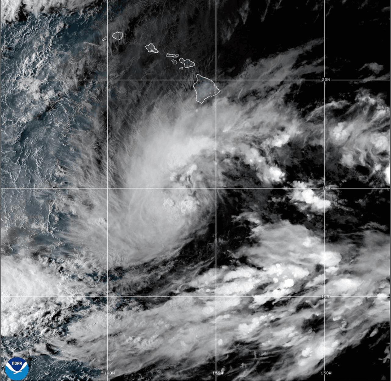
GOES Image Viewer (GeoColor) valid September 24, 2026 03:40 UTC
FORECAST TRACK SUMMARY
Nolo is expected to slow down and execute a sharp turn toward the north and north-northeast tonight into Thursday as an upper-level trough deepens northwest of the islands. A subsequent sharp turn back toward the west is forecast Friday night into Saturday as high pressure rebuilds to the north. On this projected track, the core of the storm is expected to pass approximately 85 nautical miles south of the Big Island on Saturday, before continuing roughly 215 nautical miles south of Maui, Oahu, and Kauai over the remainder of the weekend.
INTENSITY FORECAST
Steady to rapid intensification is expected over the next 48 to 72 hours. While modest easterly wind shear may temper development through early Thursday, warm ocean surface temperatures and abundant mid-level moisture will support rapid strengthening as shear relaxes. Nolo is forecast to reach hurricane strength by Thursday night and attain major hurricane intensity (Category 3 or higher) by Saturday, with peak sustained winds reaching 195 km/h (105 kt) before gradual weakening begins early next week.
WIND PROBABILITY & HIGHLIGHTS
South Point on Hawaii Island carries the highest land-based threat, with a 75% cumulative probability of tropical-storm-force winds (34 kt / 63 km/h) over the next five days, including a 36% chance of 50-kt winds and a 16% chance of hurricane-force winds (64 kt / 119 km/h), onsetting as early as Friday evening. Elsewhere on the Big Island, Hilo and Kailua-Kona carry a 37% and 39% chance of tropical-storm-force winds, respectively. Offshore waters south of the island face near-certain gale-to-storm conditions, with Buoy 51002 showing an 83% cumulative probability of 34-kt winds.
IMPACTS & THREATS
Rainfall: Catastrophic and life-threatening flash flooding and mudslides are possible across steep terrain on the Big Island, where rainfall totals of 15 to 20 inches with localized amounts up to 35 inches are expected. Maui faces 5 to 10 inches with maximums up to 20 inches, while the remaining Hawaiian islands can expect 1 to 3 inches (isolated 6 inches).
Storm Surge: The combination of a dangerous storm surge and astronomical tides will cause coastal flooding in low-lying areas of Hawaii County, with water levels reaching 1 to 3 feet above ground near peak high tide, accompanied by large, destructive breaking waves.
Swells & Surf: Swells generated by Nolo will reach exposed east- and south-facing shores of the Big Island by Friday, building through the weekend. These swells will create life-threatening surf, dangerous rip currents, and hazardous coastal conditions across southern shipping approaches.
OPERATIONAL PORT FORECASTS
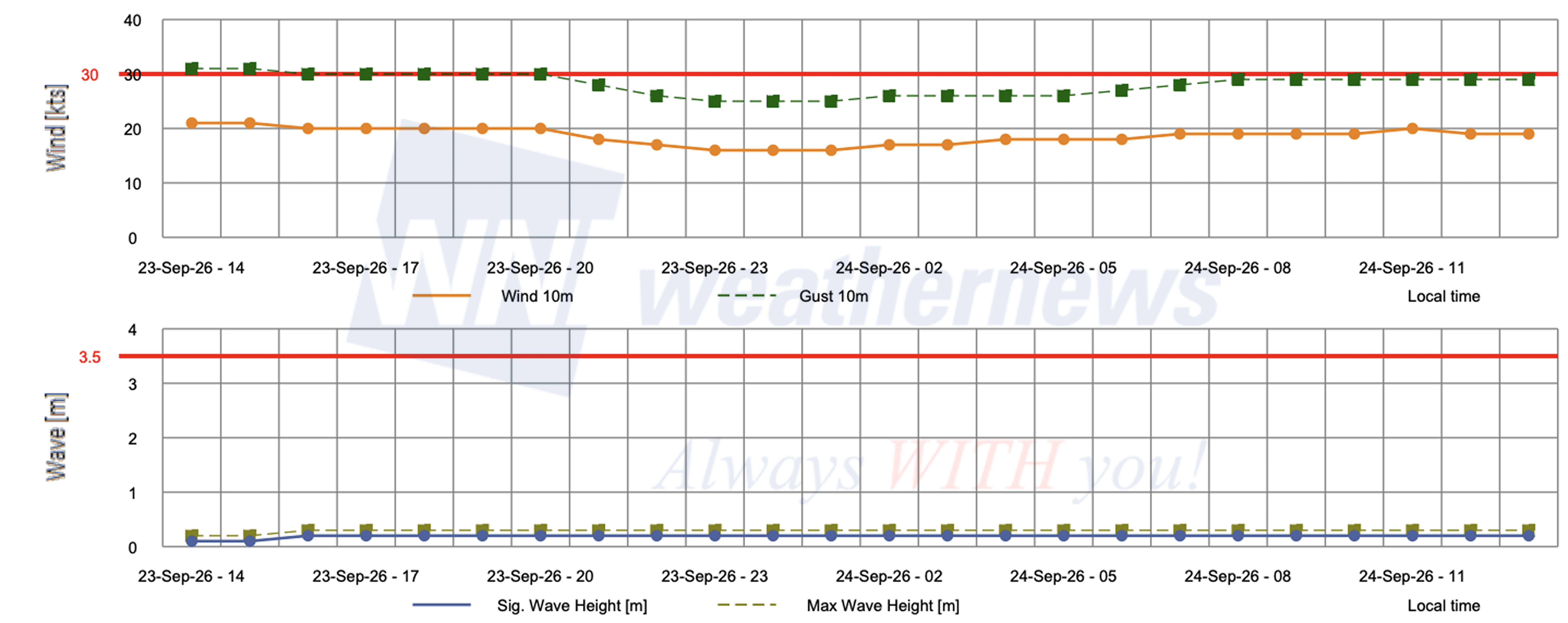
■ PORT OF HONOLULU, Hawaii, United States
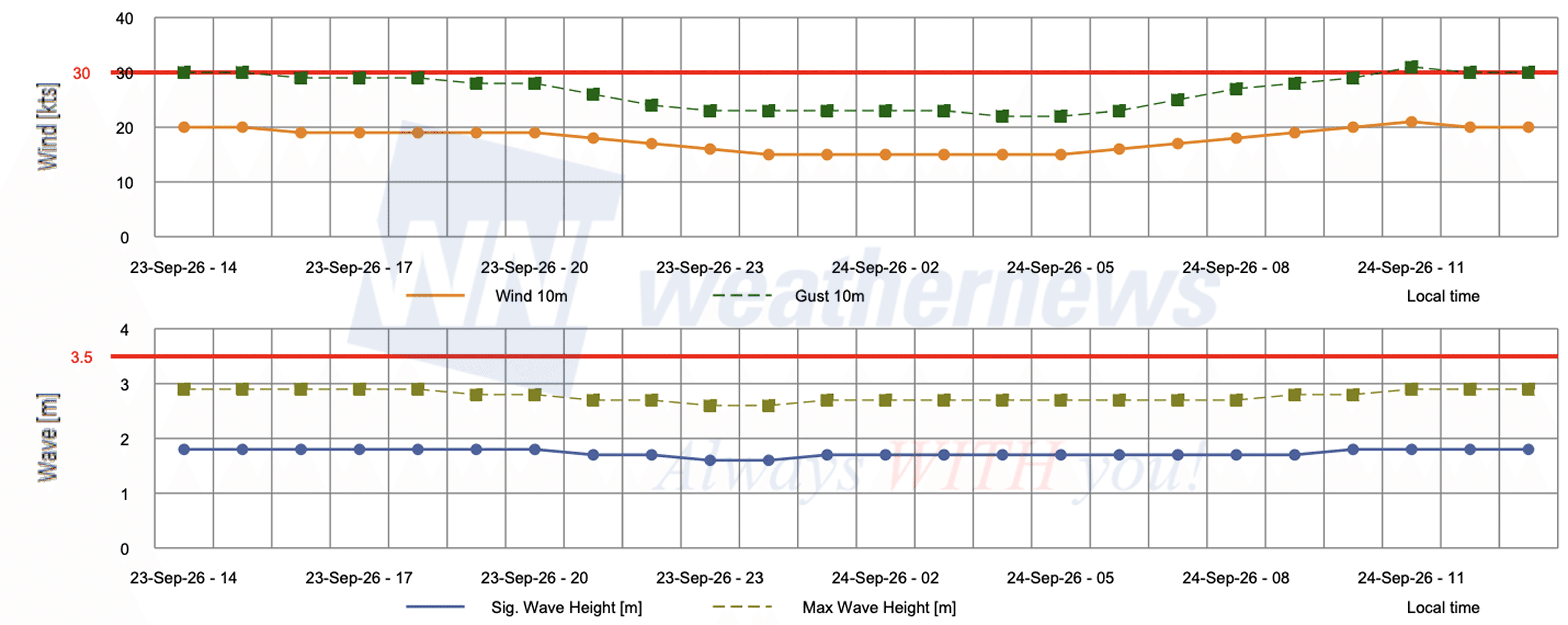
■ BARBERS POINT TERMINAL, Hawaii, United States
Weathernews Inc. assumes no liability for navigational decisions, losses, or damages resulting from reliance on this general overview.
While official observations guide the general threat assessment, highly detailed, proprietary routing and port forecasts are essential for safe navigation. Weathernews services provide customers with 24/7 localized data to ensure your vessels remain safe and well-informed. Please consult our dedicated services for the most up-to-date, detailed predictions for your specific routes and operations.
Note on the storm's name: "Nolo" is drawn from the Central North Pacific tropical cyclone name list maintained by the World Meteorological Organization (WMO). Central North Pacific tropical cyclone names are pre-selected Hawaiian names that rotate continuously across four lists. To learn more about how storms are named, please visit the World Meteorological Organization (WMO).