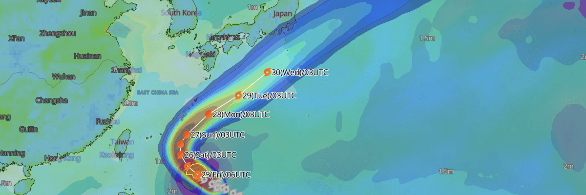
Tropical Storm No. 26 (Surigae) is tracking west-northwestward over the Philippine Sea south of the Nansei Islands and is forecast to undergo steady intensification into a typhoon as it turns northward toward waters south of Okinawa over the weekend.
CURRENT STATUS
Based on the latest JMA observations on September 25, 2026 03:45 UTC
- Location: 20.1°N, 129.9°E — approximately 650 km south of the Daito Islands and 715 km southeast of Naha, Okinawa
- Classification: Tropical Storm (TS)
- Movement: West-northwest at 11 kt (20 km/h)
- Central pressure: 1000 hPa
- Maximum sustained winds: 40 kt (75 km/h)
- Maximum gusts: 60 kt (110 km/h)
- ≥30-kt wind area: 280 km (50 NM) to the north, 165 km (90 NM) to the south
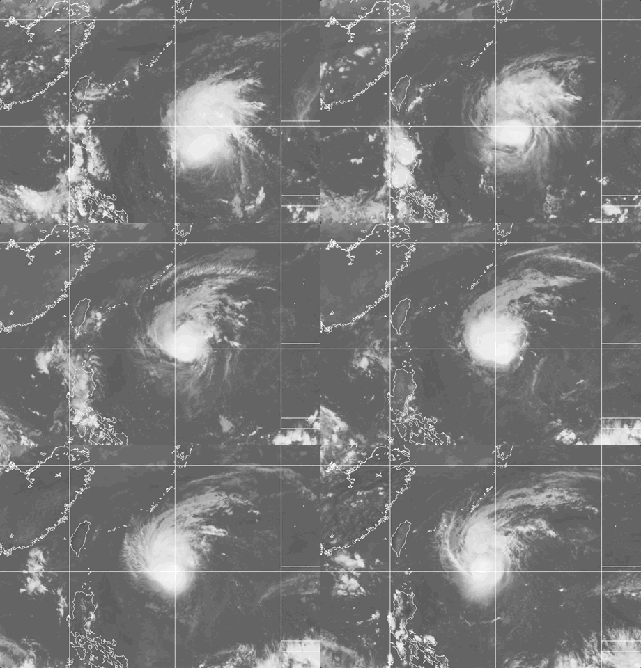
Weathernews Global Composite Satellite Imagery valid September 24, 2026 06:30 UTC to September 25, 2026 06:30 UTC
FORECAST TRACK SUMMARY
Tropical Storm No. 26 (Surigae) is forecast to track toward waters south of Okinawa through 27 September before recurving slowly toward the northeast as a strengthening typhoon.
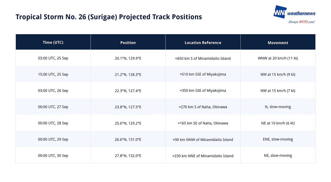
INTENSITY FORECAST
Typhoon No. 26 (Surigae) is forecast to intensify rapidly over warm tropical waters. The system is expected to strengthen into a Severe Tropical Storm (STS) by 15:00 UTC on 25 September with sustained winds of 50 kt (93 km/h) and gusts to 70 kt (130 km/h).
By 00:00 UTC on 27 September, Tropical Storm Surigae is projected to reach Typhoon (TY) intensity as central pressure drops to 975 hPa, packing sustained winds of 70 kt (130 km/h) and gusts to 100 kt (185 km/h).
Peak intensity is forecast between 28 and 29 September, with central barometric pressure deepening to 955 hPa and maximum sustained winds reaching 80 kt (150 km/h) with peak gusts up to 115 kt (215 km/h). By 30 September, the storm is expected to remain a powerful typhoon with a central pressure of 965 hPa and sustained winds of 75 kt (140 km/h).
IMPACTS & THREATS
Slowly navigating the waters south of the Nansei Islands while undergoing significant intensification into a typhoon, Tropical Storm No. 26 (Surigae) presents severe maritime and coastal wind hazards across the southwestern islands and adjacent shipping lanes from 26 through 30 September.
Strong Winds: Severe to storm-force winds will expand across the southern Nansei Islands and Philippine Sea corridors. Tropical Storm No. 26 (Surigae) currently sustains gale-force winds (≥30 kt) up to 150 NM (280 km) north and 90 NM (165 km) south of the center. A storm-force winds (≥50 kt) is forecast to establish by 03:00 UTC on 26 September with a radius of 95 NM (175 km), expanding substantially to 190 NM (350 km) by 28 September and reaching up to 310 NM (570 km) by 30 September as the core pressure plummets to 955–965 hPa. Sustained winds near the core will reach 70 to 80 kt (130 to 150 km/h) during this period.
Violent Gusts: Destructive wind gusts pose extreme risks to maritime navigation and offshore structures. Maximum gusts near the center are currently reaching 60 kt (110 km/h). Peak gusts are projected to reach 80 kt (148 km/h) by 26 September, escalating to violent gusts of 100 kt (185 km/h) on 27 September and peaking at 115 kt (215 km/h) from 28 to 29 September. Gusts of 105 kt (195 km/h) are forecast to persist through 30 September.
Weathernews Inc. assumes no liability for navigational decisions, losses, or damages resulting from reliance on this general overview.
While official observations guide the general threat assessment, highly detailed, proprietary routing and port forecasts are essential for safe navigation. Weathernews services provide customers with 24/7 localized data to ensure your vessels remain safe and well-informed. Please consult our dedicated services for the most up-to-date, detailed predictions for your specific routes and operations.
Note on the storm's name: "Surigae" is drawn from the Western North Pacific and South China Sea tropical cyclone name list, contributed by the Democratic People's Republic of Korea (North Korea), and refers to a kind of eagle (specifically the black-winged kite/hawk). The WMO and the ESCAP/WMO Typhoon Committee adopt these names sequentially to make tracking specific storms straightforward and to quickly communicate warnings. To learn more about how storms are named, please visit the World Meteorological Organization (WMO) website.