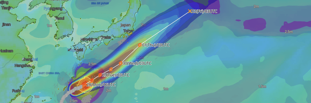
Typhoon No. 26 (Surigae) is tracking east-northeastward just north of the Daito Islands as a powerful, "very strong" typhoon, generating hazardous seas up to 7 meters and violent storm-force gusts across the southwestern islands before advancing toward the waters south of Honshu.
CURRENT STATUS
Based on the latest JMA observations on SSeptember 28, 2026 03:45 UTC
- Location: 26.9°N, 131.6°E — approximately 110 km north of Kitadaito Island and 125 km north of Minamidaito Island
- Classification/ Intensity: Typhoon (TY) / Very Strong
- Movement: East-northeast at 9 kt (15 km/h)
- Central pressure: 955 hPa
- Maximum sustained winds: 90 kt (165 km/h)
- Maximum gusts: 130 kt (240 km/h)
- ≥30-kt wind area: 220 km (120 NM ) to the southeast, 165 km (90 NM) to the northwest
- ≥50-kt wind area: 100 km (55 NM) to the south, 85 km (45 NM) to the north
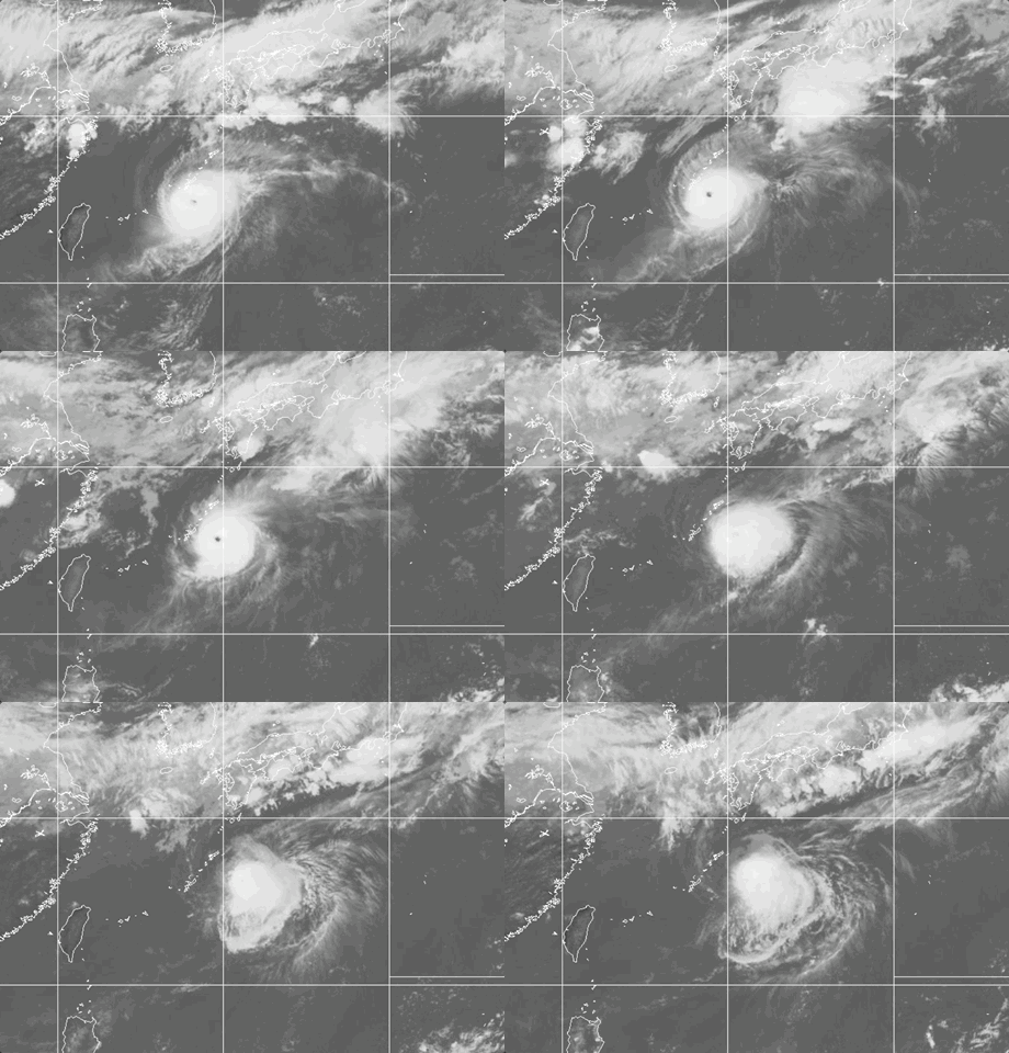
Weathernews Global Composite Satellite Imagery valid September 27, 2026 06:30 UTC to September 28, 2026 05:30 UTC
FORECAST TRACK SUMMARY
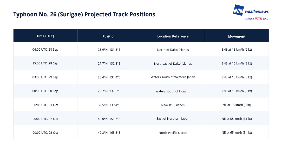
Typhoon No. 26 (Surigae) tracks east-northeastward north of the Daito archipelago at 8 to 9 kt (15 km/h). The powerful system is forecast to traverse key Pacific shipping lanes south of Honshu through 30 September, skirting the Izu Islands on 1 October before accelerating rapidly northeastward across the Great Circle corridors as an extratropical system by 3 October.
INTENSITY FORECAST
Typhoon No. 26 (Surigae) is currently operating near its peak intensity, packing sustained winds of 90 kt (165 km/h) and a central barometric pressure of 955 hPa. The system is expected to maintain its "very strong" status through 15:00 UTC, 28 September with sustained winds of 85 kt (157 km/h) and gusts up to 120 kt (220 km/h).
A steady weakening trend will commence on 29 September as the storm encounters cooler sea surface temperatures and increasing vertical wind shear south of Honshu. Central pressure is forecast to rise to 970 hPa by 03:00 UTC on 29 September and 980 hPa by 00:00 UTC on 30 September.
Surigae is projected to weaken to a Severe Tropical Storm (STS) by 00:00 UTC on 1 October with sustained winds of 55 kt (102 km/h), before transitioning to an extratropical low over the subarctic North Pacific by 3 October.
IMPACTS & THREATS
Passing just north of the Daito Islands while steering into the open maritime corridors south of mainland Japan, Typhoon No. 26 (Surigae) presents immediate severe threats involving dangerous sea states, storm-force winds, and convective squalls through at least 29 September.
Dangerous Waves: High seas and heavy ocean swells will severely impact waters across the Nansei Islands through 29 September. In the Okinawa region (including the Daito Islands), wave heights are forecast to reach 7 meters with heavy swells on 28 September, remaining high at 5 meters with swells on 29 September. Waters in the Amami region face wave heights of 4 meters with swells on 28 September. Marine operations, inter-island ferry services, and vessel navigation should exercise extreme caution across these sectors.
Strong Winds: Severe to storm-force winds will affect island communities and surrounding maritime passages. Surigae currently sustains 50-kt storm-force winds within 55 NM (100 km) south and 45 NM (85 km) north of its center, with core sustained winds reaching 90 kt (165 km/h). Across the Okinawa region, maximum sustained winds are forecast to reach 49 kt (90 km/h) with peak gusts to 68 kt (125 km/h) on 28 September. On 29 September, sustained winds will ease to 29 kt (55 km/h) with gusts up to 49 kt (90 km/h).
Severe Convective Weather & Squalls: Deep tropical moisture drawn into the storm's circulation is generating intense atmospheric instability. Warning for heightened risks of lightning strikes, localized violent squalls, and potential tornadoes associated with developing convective rain bands near the storm's periphery on 28 September.
Weathernews Inc. assumes no liability for navigational decisions, losses, or damages resulting from reliance on this general overview.
While official observations guide the general threat assessment, highly detailed, proprietary routing and port forecasts are essential for safe navigation. Weathernews services provide customers with 24/7 localized data to ensure your vessels remain safe and well-informed. Please consult our dedicated services for the most up-to-date, detailed predictions for your specific routes and operations.
Note on the storm's name: "Surigae" is drawn from the Western North Pacific and South China Sea tropical cyclone name list, contributed by the Democratic People's Republic of Korea (North Korea), and refers to a kind of eagle (specifically the black-winged kite/hawk). The WMO and the ESCAP/WMO Typhoon Committee adopt these names sequentially to make tracking specific storms straightforward and to quickly communicate warnings. To learn more about how storms are named, please visit the World Meteorological Organization (WMO) website.