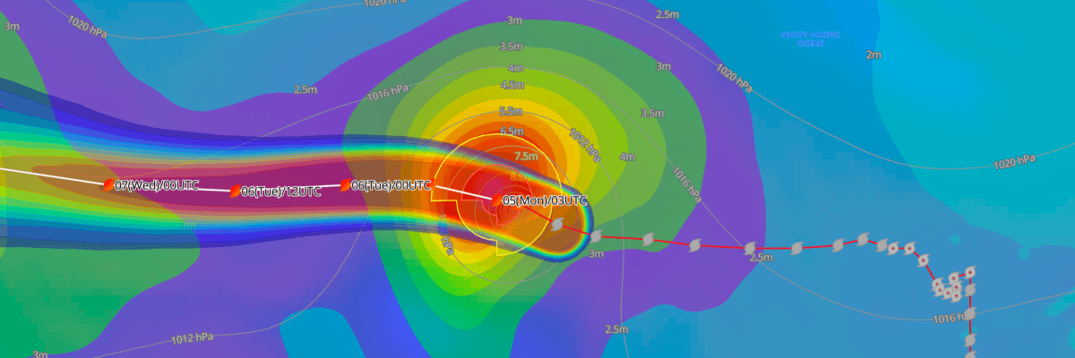
Typhoon No. 28 (Nolo), a system first monitored in the Central North Pacific by the Central Pacific Hurricane Center (CPHC), has held its strength and moved into the Japan Meteorological Agency (JMA) area of responsibility. JMA analyzed it at 03 UTC on Oct. 5 (12:00 JST) as a Very Strong typhoon with maximum sustained winds of 95 kt (176 km/h).
CURRENT STATUS
Based on the latest JMA analysis on October 5, 2026 04:00 UTC
- Location: 25.0°N, 178.6°E, just west of the International Date Line
- Intensity: Typhoon, Very Strong
- Movement: West at 16 kt (30 km/h)
- Central pressure: 950 hPa
- Maximum sustained winds: 95 kt (176 km/h), with gusts to 135 kt (250 km/h)
- Wind radii: 50-kt winds extend 70 NM (130 km) from the center. 30-kt winds extend 210 NM (390 km).
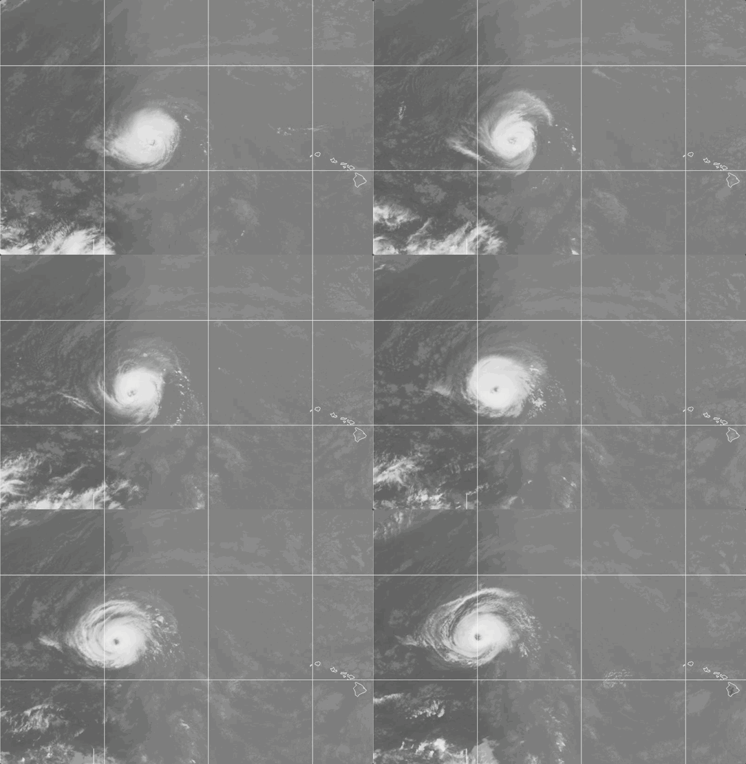
Weathernews Global Composite Satellite Imagery valid October 4, 2026 04:30 UTC to October 5, 2026 04:30 UTC
FORECAST TRACK SUMMARY
Because the system has moved from CPHC to JMA responsibility, it keeps the name Nolo and now receives a JMA typhoon number. JMA forecasts Typhoon No. 28 (Nolo) to continue moving west, reaching 25.6°N, 175.4°E at 15 UTC Oct. 5 (00:00 JST Oct. 6). It is then forecast to reach 25.6°N, 172.2°E at 03 UTC Oct. 6 (12:00 JST). Speed is expected to increase to 19 kt (35 km/h) by 00 UTC Oct. 7 (09:00 JST), when the center is forecast near 25.6°N, 164.5°E.
The track is then forecast to curve toward the northwest. The center is forecast near 26.9°N, 156.3°E at 00 UTC Oct. 8 and near 29.1°N, 150.9°E at 00 UTC Oct. 9. The system is expected to slow to 7 kt (15 km/h) and reach 31.4°N, 148.7°E by 00 UTC Oct. 10 (09:00 JST), moving northwest. The forecast circle of probability grows from 35 NM (65 km) at 15 UTC Oct. 5 to 180 NM (330 km) by 00 UTC Oct. 10. Track uncertainty is therefore expected to increase with time.
INTENSITY FORECAST
Nolo is forecast to hold 95 kt (176 km/h) and 950 hPa through 15 UTC Oct. 5. It is then expected to weaken gradually:
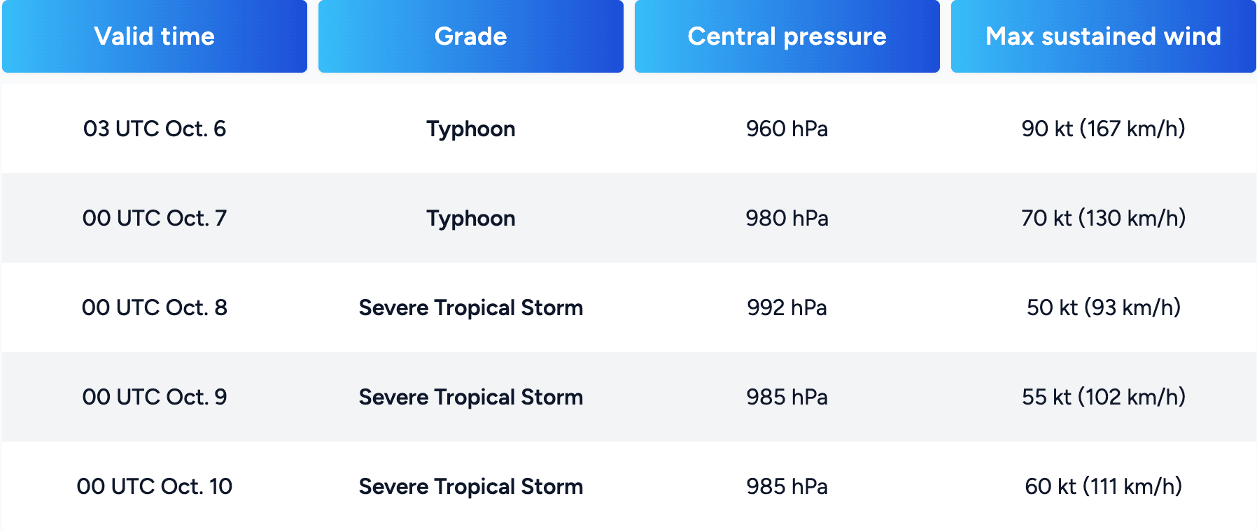
The grade changes from Typhoon to Severe Tropical Storm between Oct. 7 and Oct. 8. JMA's forecast shows a slight strengthening after Oct. 8.
IMPACTS & THREATS
JMA's data show no landfall and no warnings in effect. The main concern is to vessels crossing the open subtropical North Pacific. Storm warning areas are forecast to extend 105 NM (190 km) from the center at 15 UTC Oct. 5, growing to 225 NM (420 km) by 00 UTC Oct. 10. Rough seas and strong winds may affect vessels within and near these areas. JMA does not give a storm warning area radius for 00 UTC Oct. 8.
Mariners should monitor later JMA advisories as Nolo approaches waters south of Japan around Oct. 10. The track and intensity forecast carry considerable uncertainty at that range.
Weathernews Inc. assumes no liability for navigational decisions, losses, or damages resulting from reliance on this general overview.
While official observations guide the general threat assessment, highly detailed, proprietary routing and port forecasts are essential for safe navigation. Weathernews services provide customers with 24/7 localized data to ensure your vessels remain safe and well-informed. Please consult our dedicated services for the most up-to-date, detailed predictions for your specific routes and operations.
Note on the storm's name: "Nolo" is drawn from the Central North Pacific tropical cyclone name list maintained by the World Meteorological Organization (WMO). Central North Pacific tropical cyclone names are pre-selected Hawaiian names that rotate continuously across four lists. To learn more about how storms are named, please visit the World Meteorological Organization (WMO).