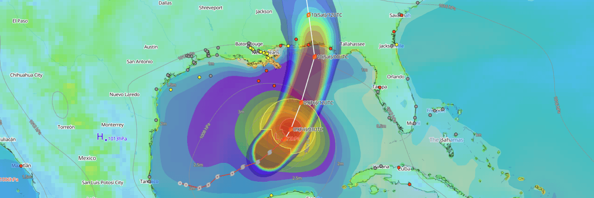
Hurricane Isaias is a Category 2 hurricane over the central Gulf of Mexico, about 415 km (260 mi) south of the mouth of the Mississippi River, according to the National Hurricane Center (NHC). Maximum sustained winds are 165 km/h (90 kt / 105 mph) and central pressure is 969 mb (969 hPa). NHC forecasts landfall on the northern Gulf Coast late Friday or early Saturday, with a brief strengthening to major hurricane strength possible beforehand.
CURRENT STATUS
Based on the latest NHC Public Advisory analysis on October 9, 2026 03:00 UTC
- Location: 25.4°N, 88.4°W, about 475 km (295 mi) north-northeast of Progreso, Mexico, and 415 km (260 mi) south of the mouth of the Mississippi River
- Intensity: Category 2 hurricane
- Movement: Northeast at 22 km/h (12 kt / 14 mph)
- Central pressure: 969 mb (969 hPa)
- Maximum sustained winds: 165 km/h (90 kt / 105 mph)
- Maximum gusts: 205 km/h (110 kt / 125 mph)
- Hurricane-force winds (64 kt) radius: up to 35 km (25 mi / 20 nm) from center
- Tropical-storm-force winds (34 kt) radius: up to 205 km (125 mi / 110 nm) from center
- Hurricane Warning: Ocean Springs, Mississippi, to the Bay/Gulf County Line, Florida
- Storm Surge Warning: Mouth of the Mississippi River to the Suwannee River, Florida
- Tropical Storm Warning: Jefferson/Plaquemines Parish Line, Louisiana, to west of Ocean Springs, Mississippi; and east of the Bay/Gulf County Line to the Aucilla River, Florida
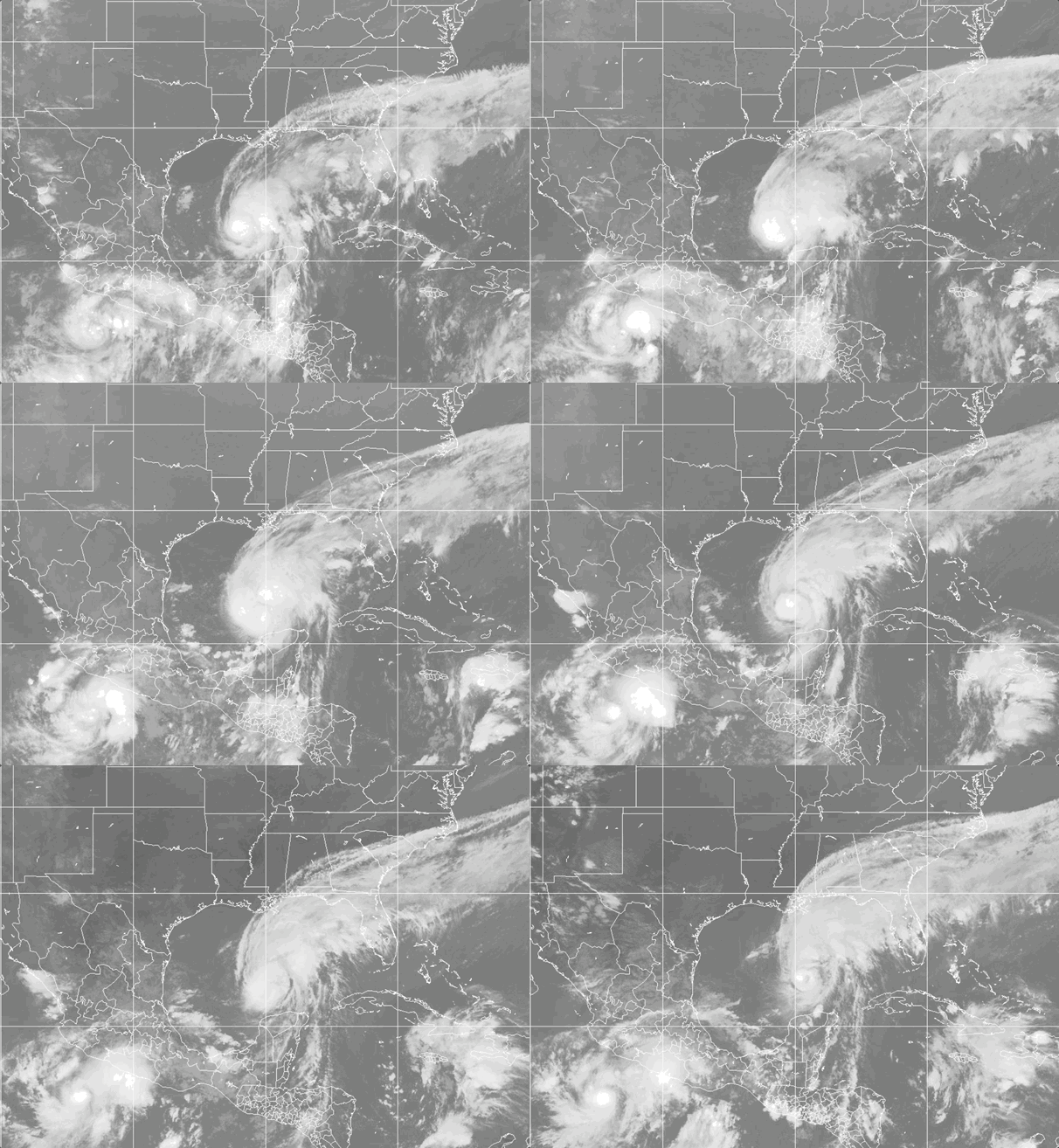
Weathernews Global Composite Satellite Imagery valid October 8, 2026 02:30 UTC to October 9, 2026 02:30 UTC
FORECAST TRACK SUMMARY
Isaias is forecast to turn north and accelerate on Friday. The center is expected to reach the coast within the Hurricane Warning area late Friday or early Saturday. It then moves inland across Alabama, weakens to a post-tropical remnant low by Sunday, and dissipates by Tuesday.
INTENSITY FORECAST
Expect Isaias to peak near 100 kt (115 mph) early Friday, which would make it a major hurricane. Increasing wind shear should cause some weakening before landfall. Isaias is expected to remain a dangerous hurricane at landfall, and its wind field is expected to expand.
WIND PROBABILITY & HIGHLIGHTS
Pensacola, Florida, has a 94% chance of tropical-storm-force winds (34 kt / 39 mph) and a 14% chance of hurricane-force winds (64 kt / 74 mph) during the period from 1200 UTC Friday to 1200 UTC Saturday. Destin, Florida, has an 88% chance, Panama City, Florida, 63%, and Mobile, Alabama, 44% of tropical-storm-force winds over the same period.
IMPACTS & THREATS
Rain: Rainfall of 4 to 8 inches, with local totals up to 15 inches, is forecast from Friday through the weekend across southern Alabama, the Florida Panhandle and Big Bend, and southwest Georgia. Flash flooding is likely, and significant river flooding is possible.
Swells: Swells are affecting the western and northern Yucatan Peninsula and will spread toward the Gulf Coast on Friday. They are likely to cause life-threatening surf and rip currents.
Wind and storm surge: Storm surge could reach 5 to 7 feet above ground from Dauphin Island, Alabama, to Indian Pass, Florida. Surge of 4 to 6 feet is forecast for Ocean Springs to Dauphin Island, Mobile Bay, and Indian Pass to the Steinhatchee River. Damaging hurricane-force winds are expected Friday night into early Saturday. Damaging gusts and tornadoes are also possible well inland across Alabama and Georgia.
Mariners should watch for rapid changes in intensity before landfall. Additional watches and warnings may be needed for inland Alabama and Georgia.
OPERATIONAL PORT FORECASTS
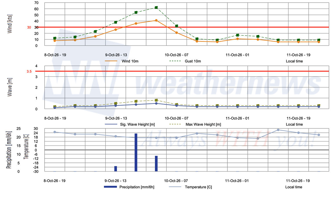
■ MOBILE, Alabama, United States
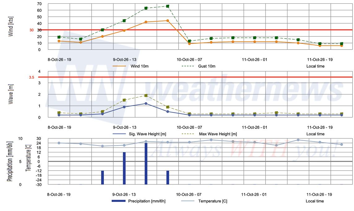
■ PANAMA CITY, Florida, United States
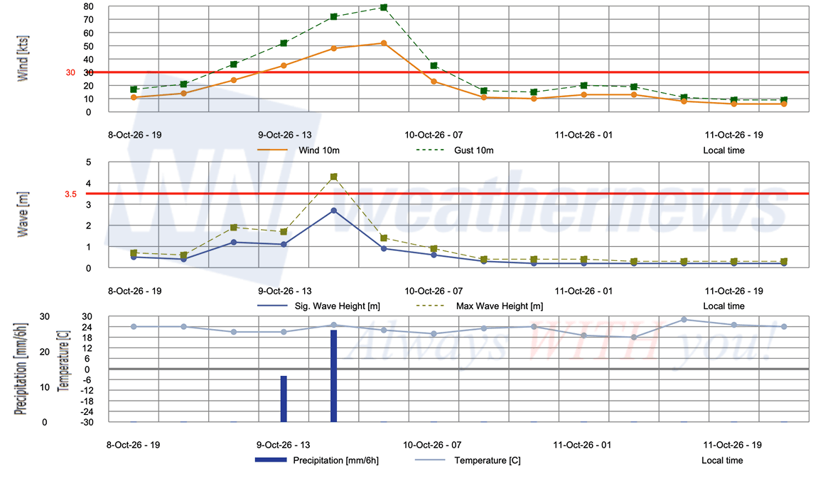
■ PENSACOLA, Florida, United States
Weathernews Inc. assumes no liability for navigational decisions, losses, or damages resulting from reliance on this general overview.
While official observations guide the general threat assessment, highly detailed, proprietary routing and port forecasts are essential for safe navigation. Weathernews services provide customers with 24/7 localized data to ensure your vessels remain safe and well-informed. Please consult our dedicated services for the most up-to-date, detailed predictions for your specific routes and operations.
Note on the storm's name: "Isaias" is drawn from the 2026 Caribbean Sea, Gulf of Mexico and the North Atlantic tropical cyclone name list, the ninth name in the season's sequence. Caribbean Sea, Gulf of Mexico and the North Atlantic tropical cyclone names are pre-selected from twenty one rotating lists. To learn more about how storms are named, please visit the World Meteorological Organization (WMO).