A Shallow, Widely Felt Quake
At approximately 12:56 p.m. local time (17:56 UTC) on October 9, a strong earthquake struck central Panama, with its epicenter reported near the Azuero Peninsula, about 39 km northwest of Tonosí. Magnitude estimates diverge by source: Panama's University Institute of Geosciences, cited by the Pan American Health Organization, reported 7.5; USGS data cited by Reuters put it at 7.7. The quake's depth of roughly 12 km made it shallow, and it was felt across much of the country. Panama declared a state of emergency on October 10. By October 11, Reuters reported more than 200 aftershocks, 27 people injured, and nearly 900 homes damaged.
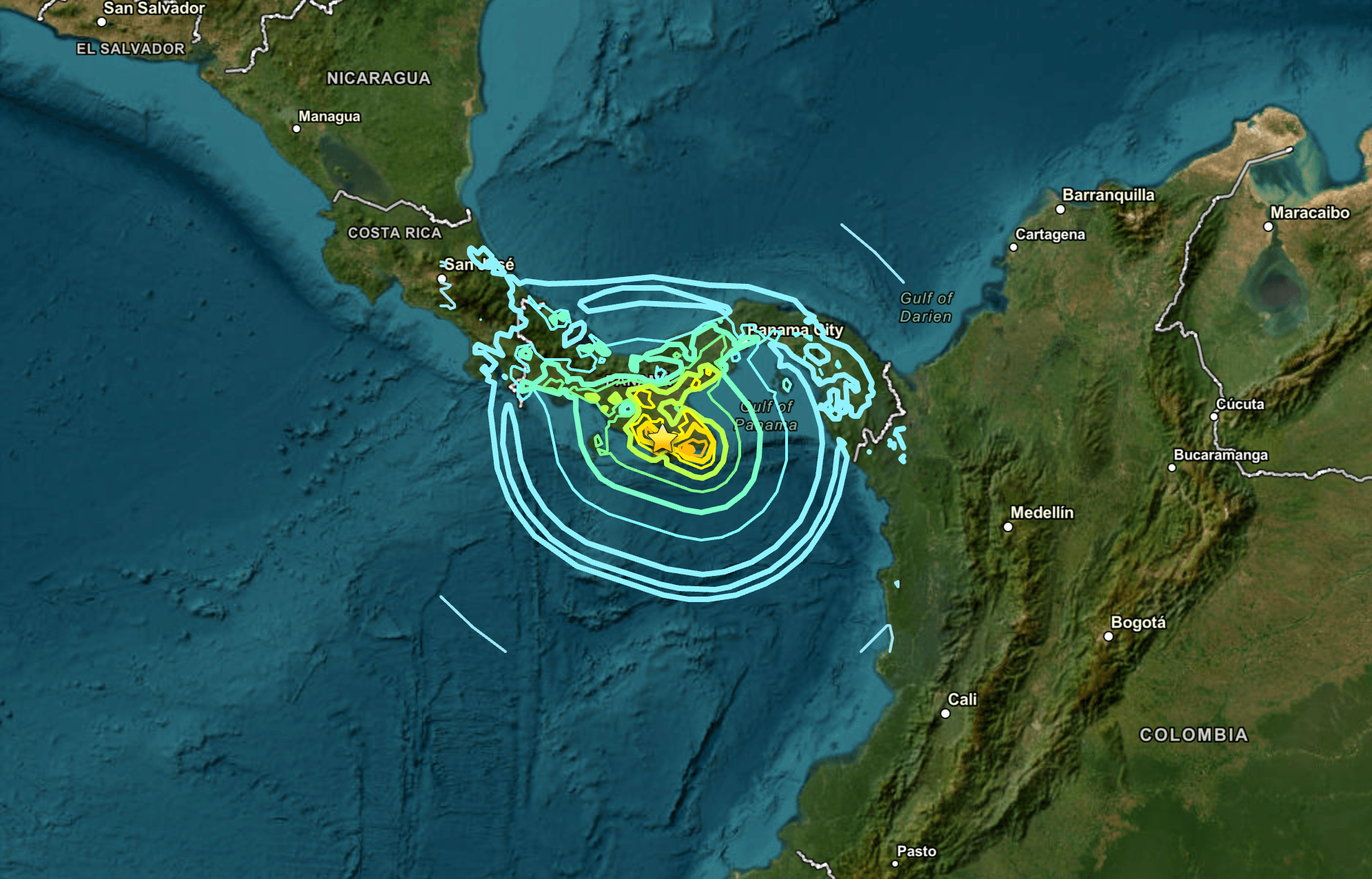
Source: U.S. Geological Survey (USGS), earthquake event map. Screenshot by author.
The Canal Held
The Panama Canal Authority (ACP) activated emergency protocols immediately, dispatching technical teams to inspect locks (Miraflores, Pedro Miguel, Gatún, and the expanded Agua Clara lane), Gatún Lake's dam infrastructure, and major bridges. Reporting by La Prensa Panama identified only minor damage — four Pacific-side office buildings and steelwork on an elevated water tank at the Monte Esperanza water plant in Colón province — none of which affected vessel transits.
Smaller Ports Told a Different Story
Panama's Maritime Authority (AMP) announced precautionary closures on October 12 at several state-operated ports, including Puerto Vidal and Puerto Mutis in Veraguas, Puerto Almirante in Bocas del Toro, and installations in Coclé, Herrera, and Los Santos. By October 13, AMP reported that roughly 80% of the affected activities — vessel departures, authorizations, and embarkation operations — had resumed. This figure describes the scope of that specific notice, not Panama's national port capacity. Exceptions remained: Puerto Mutis stayed closed on Sistema Nacional de Protección Civil (SINAPROC)'s recommendation; Puerto Búcaro was inaccessible due to road conditions; and the El Agallito pier remained closed, though its offices continued operating.
Commercial container terminals saw only brief procedural pauses rather than closures: MIT's gates ran continuously apart from preventive evacuations, Balboa and Colon Container Terminal extended gate hours, and PSA Panama's Rodman terminal resumed gate operations by 13:30 on October 10.
What the AIS Data Shows
Daily AIS tracking of commercial cargo vessels (cargo and tankers) in the canal area from October 1–14 shows unique vessel counts holding steady between 188 and 218, with transits ranging from 24 to 37 per day. October 9 recorded the lowest figures of the window — 24 transits and 188 vessels, tied with the previous day — against an average of roughly 31 transits on the other 13 days. Activity rebounded immediately: 31 transits on October 10, climbing to 218 vessels by October 14, the highest count of the period.
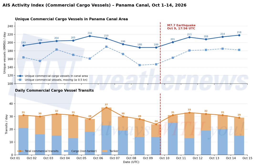
AIS Analysis by Weathernews Inc.; AIS Source Data: Marine Traffic by Kpler
An hourly breakdown of October 9 narrows the dip further. Transits in the first 17 hours of the day (11) closely matched the prior day (10). The shortfall was concentrated in the evening: in the six hours following the quake, transits ran roughly 30% below the same window the previous evening (12 versus 17), with one hour — 19:00 UTC — recording no transits at all. Activity resumed from 20:00 UTC. A separate midday gap in transits, present on both October 8 and 9, appears unrelated to the quake.
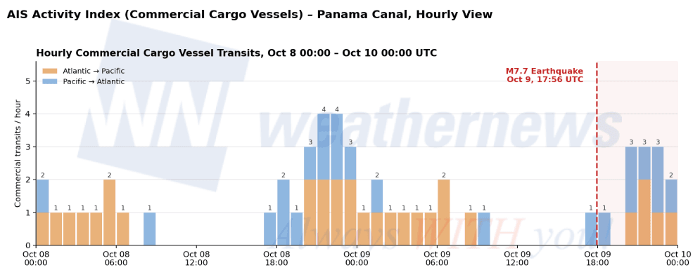
AIS Analysis by Weathernews Inc.; AIS Source Data: Marine Traffic by Kpler
This is broadly consistent with contemporaneous reporting: El Canal de Panamá (EFE) report, republished by Swissinfo, recorded 40 vessels queued to transit on October 9 (37 with reservations, three without) — a snapshot of the queue rather than evidence of a quake-driven backlog — while Reuters reported on October 11 that canal shipping operations remained unaffected.
What to Watch
State-port recovery: Puerto Mutis remained closed as of AMP's October 13 update, with no newer information available.
Aftershock activity: Over 200 aftershocks had been recorded as of October 11, along the Pacific–Nazca plate boundary.
Structural vulnerabilities, hypothetically: This earthquake did not test the canal's known pressure points: the Pedro Miguel Fault runs beneath its lock structures, Gatún Lake's dam system is the canal's sole water source, and the Gaillard Cut's steep slopes are landslide-prone. The canal's gravity-based design and post-2016 seismic reinforcements held this time, with the epicenter roughly 150–200 km away. A direct-hit rupture or major slope failure remains a theoretical, closely watched risk.
Market exposure: The canal carries an estimated 5% of global trade. A sustained closure would force rerouting via the Strait of Magellan, adding 15–20 transit days and significant fuel costs per voyage — a scenario this earthquake did not trigger, but one worth monitoring given continued seismic activity.
What We Know — and Why It's Limited
Magnitude estimates vary between Panamanian and U.S. sources, and some damage assessments were still underway as of mid-October. AIS tracking also has physical limits: Puerto Mutis sits roughly 10 nautical miles up the Río San Pedro, an inland riverine location generally outside AIS receiver range. For that part of the story, this reporting relies on AMP's official statements rather than independent vessel tracking.
Methodology note
- Both charts are based on Weathernews Inc. analysis of MarineTraffic (Kpler) AIS data and Lloyd's ship master data, covering vessel activity in and around the Panama Canal.
- Commercial cargo means vessels classed as "Cargo Carrying" in Lloyd's ship data, which includes tankers. Where there is no Lloyd's match, AIS ship type codes 70–79 (cargo) and 80–89 (tanker) are used instead. Passenger ships, tugs, fishing vessels, and other work vessels are excluded.
- Transit logic: A transit is counted when a vessel is detected in an Atlantic-side zone and its next detection is in a Pacific-side zone, or the reverse, within 96 hours. It is credited to whichever period — day or hour — it is first detected in the second zone, which marks arrival at that side of the canal, not passage through the locks.
- These figures are AIS-based estimates and are not official Panama Canal Authority statistics.
- Daily trend (Oct. 1–14): Unique vessel counts reflect ships detected each UTC day within a single study area (8.8–9.5°N, 79.4–80.1°W), including vessels at anchor near both ends of the canal.
- Hourly trend (Oct. 8, 00:00 UTC – Oct. 10, 00:00 UTC): The study area is split into two zones for more precise transit detection: an Atlantic-side zone (9.30–9.50°N, 79.85–80.05°W, north of the Gatún Locks) and a Pacific-side zone (8.80–8.97°N, 79.45–79.62°W, south of the Miraflores Locks). To avoid missing transits that began before Oct. 8, vessel positions from Oct. 5 onward were used. Hourly counts are small (zero to four per hour), so differences of a few transits can reflect normal variation rather than a meaningful change. The earthquake time (Oct. 9, 17:56 UTC) is shown for reference only; the data shows when transits were detected, not why activity changed.
Disclaimer: The banner image is a stock photograph used for illustrative purposes and is not associated with or taken at the event described in this article.