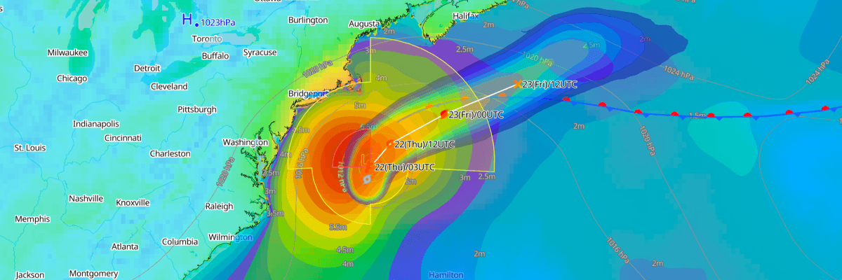
Subtropical Storm Josephine is about 245 miles south of Nantucket, Massachusetts, with maximum sustained winds of 55 kt (65 mph) and a minimum central pressure of 988 mb (988 hPa). It is moving north-northeast at 5 kt (6 mph). NHC forecasts Josephine will turn northeast and accelerate Thursday, then become a hurricane-force post-tropical cyclone. Large swells and coastal flooding are the main threats to shipping and ports.
CURRENT STATUS
Based on the latest NHC Public Advisory analysis on October 22, 2026 03:00 UTC
- Location: 37.7°N, 69.4°W, about 390 km (245 mi) south of Nantucket, Massachusetts, and 905 km (565 mi) southwest of Halifax, Nova Scotia
- Intensity: Subtropical storm
- Movement: North-northeast at 9 km/h (5 kt / 6 mph)
- Central pressure: 988 mb (988 hPa)
- Maximum sustained winds: 100 km/h (55 kt / 65 mph)
- Maximum gusts: 120 km/h (65 kt / 75 mph)
- Tropical-storm-force winds (34 kt) radius: up to 665 km (415 mi / 360 nm) from center, largest to the northeast
- Storm-force winds (50 kt) radius: up to 205 km (125 mi / 110 nm) from center, northwest side only
- Seas of 4 m (13 ft) or higher: up to 1,000 km (620 mi / 540 nm) from center, largest to the southwest
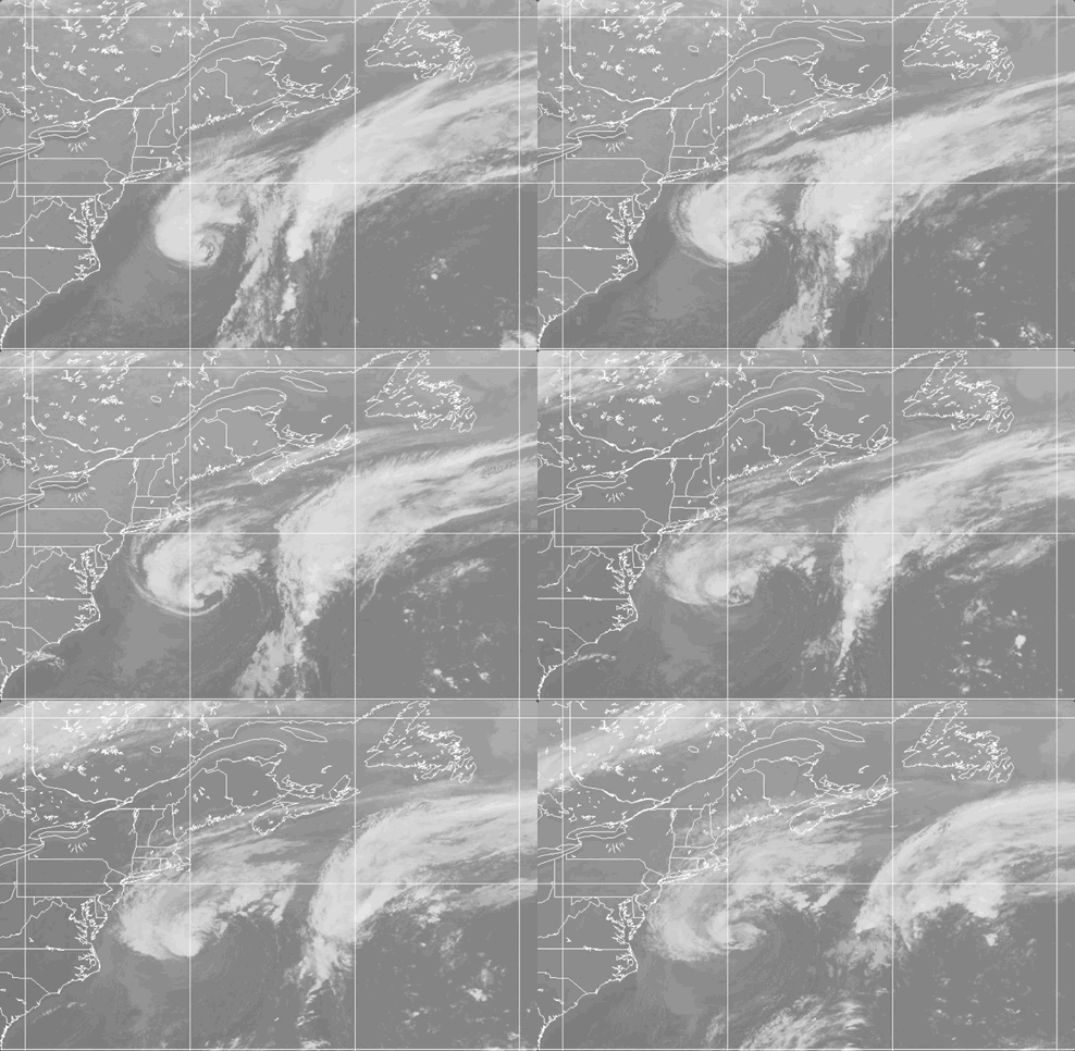
Weathernews Global Composite Satellite Imagery valid October 21, 2026 03:30 UTC to October 22, 2026 02:30 UTC
FORECAST TRACK SUMMARY
NHC expects Josephine to turn northeast Thursday and then move east on Friday and into the weekend. The center is forecast to stay south of Nova Scotia and Newfoundland, passing south of Newfoundland late Friday into Friday night. NHC expects it to be absorbed by a larger extratropical low over the North Atlantic by early Monday.
INTENSITY FORECAST
Josephine is forecast to strengthen and become a post-tropical cyclone with hurricane-force winds of about 65 kt (75 mph) by early Friday UTC. It will move over much cooler water and meet a strong approaching upper-level trough. Gradual weakening is forecast to begin Friday.
WIND PROBABILITY & HIGHLIGHTS
In the first 12 hours (0000 to 1200 UTC Thursday), there is a 99% chance of tropical-storm-force winds (34 kt / 39 mph) at Nantucket, Massachusetts, and 88% at Hyannis, Massachusetts. Sable Island, Nova Scotia, has an 87% chance of tropical-storm-force winds through 1200 UTC Friday and a 27% chance of 50 kt (58 mph) winds. Cape Race, Newfoundland, has a 43% chance of tropical-storm-force winds through 0000 UTC Sunday.
IMPACTS & THREATS
Gale-force gusts are possible along parts of the northeastern U.S. coast through Thursday. Minor to locally moderate coastal flooding is ongoing along the Mid-Atlantic coast and will continue around high tides through the week. Large swells are affecting much of the U.S. eastern seaboard and parts of Atlantic Canada, creating life-threatening surf and rip currents.
OPERATIONAL PORT FORECASTS
■ HALIFAX, Nova Scotia, Canada
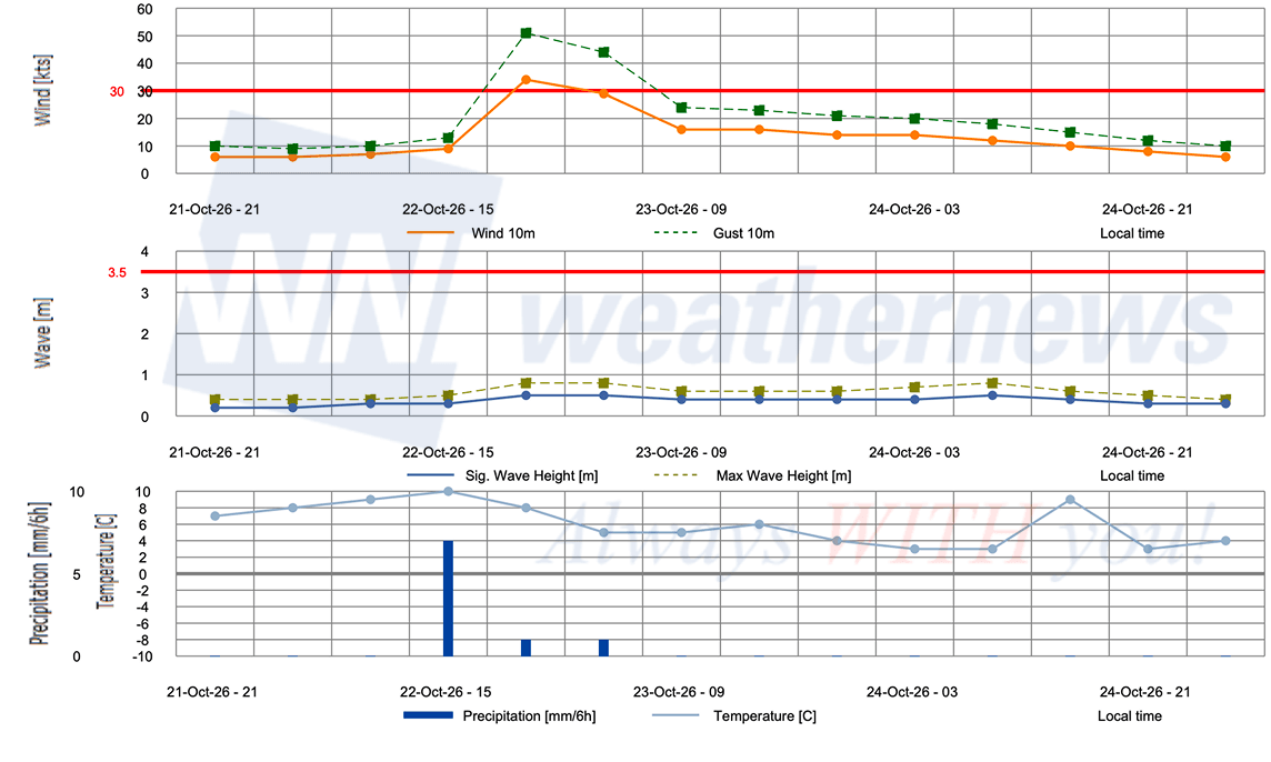
■ SYDNEY, Nova Scotia, Canada
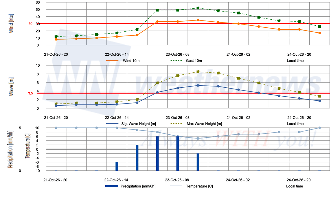
Weathernews Inc. assumes no liability for navigational decisions, losses, or damages resulting from reliance on this general overview.
While official observations guide the general threat assessment, highly detailed, proprietary routing and port forecasts are essential for safe navigation. Weathernews services provide customers with 24/7 localized data to ensure your vessels remain safe and well-informed. Please consult our dedicated services for the most up-to-date, detailed predictions for your specific routes and operations.
Note on the storm's name: "Josephine" is drawn from the 2026 Caribbean Sea, Gulf of Mexico and the North Atlantic tropical cyclone name list, the tenth name in the season's sequence. Caribbean Sea, Gulf of Mexico and the North Atlantic tropical cyclone names are pre-selected from twenty one rotating lists. To learn more about how storms are named, please visit the World Meteorological Organization (WMO).