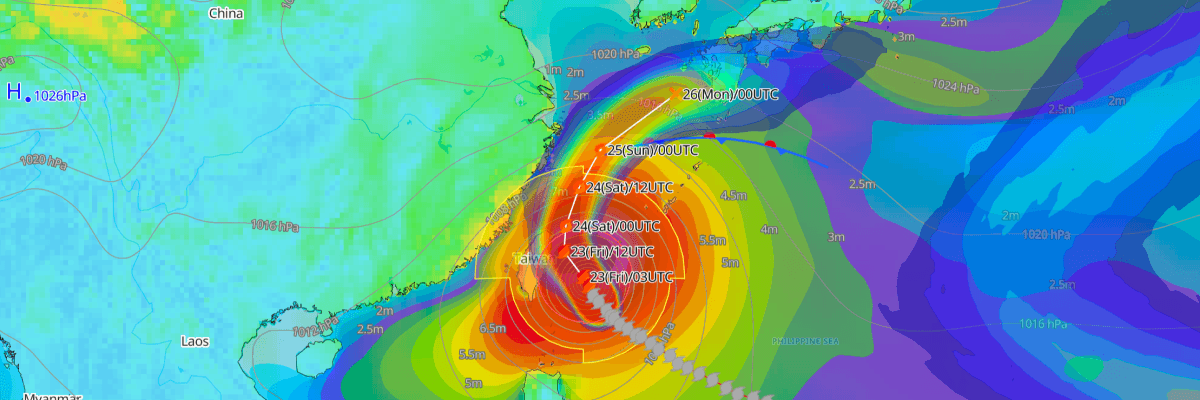
Typhoon No. 30 (Champi) is a large typhoon moving north-northwest east of Taiwan. It is packing maximum sustained winds of 80 kt (148 km/h) and a central pressure of 955 hPa, according to the Japan Meteorological Agency (JMA). JMA forecasts it to weaken gradually as it curves north and then northeast, and to become an extratropical low south of Honshu by 27 October.
CURRENT STATUS
Based on the latest JMA observations on 23 October, 2026 03:00 UTC
- Location: 23.2°N, 123.6°E (analysis at 03 UTC / 12:00 JST, 23 October)
- Intensity: Typhoon (JMA grade TY), large in scale
- Movement: NNW at 9 kt (15 km/h)
- Central pressure: 955 hPa
- Maximum sustained winds: 80 kt (148 km/h), with gusts to 115 kt (213 km/h)
- Wind radii: Winds of 50 kt or more extend up to 180 NM (330 km) to the northwest and 150 NM (280 km) to the southeast. Winds of 30 kt or more extend 450 NM (850 km) to the north and 350 NM (650 km) to the south.
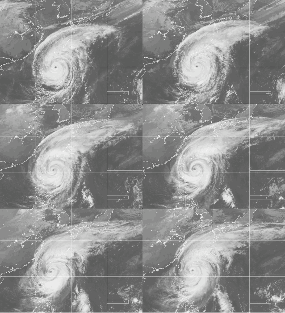
Weathernews Global Composite Satellite Imagery valid October 22, 2026 03:30 UTC to October 23, 2026 03:30 UTC
FORECAST TRACK SUMMARY
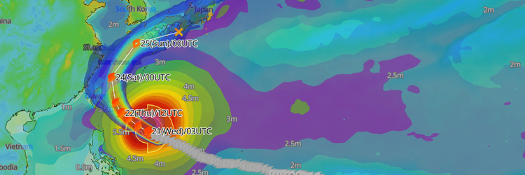
According to JMA, Typhoon No. 30 (Champi) is forecast to move slowly west-northwest near the Sakishima Islands and northeastern Taiwan, then curve north into the East China Sea and northeast toward Kyushu, with the projected positions shown below.
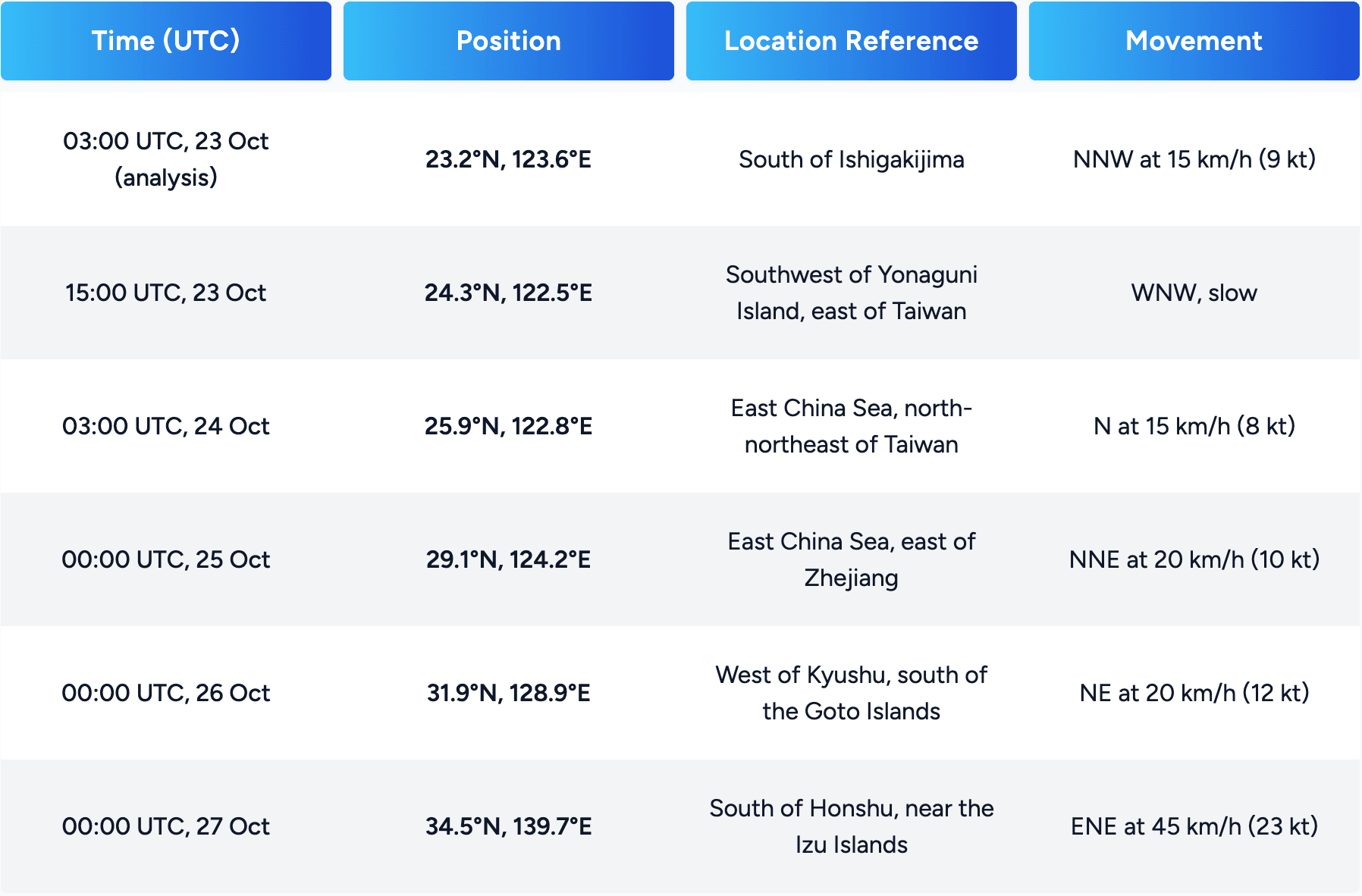
Track uncertainty increases with time. The probability circle grows from 30 NM (55 km) at 15 UTC on 23 October to 100 NM (185 km) on 25 October, and to 200 NM (370 km) by 27 October.
INTENSITY FORECAST
JMA's guidance shows a steady weakening trend:
- 15 UTC, 23 October: Typhoon, 970 hPa, 70 kt (130 km/h)
- 03 UTC, 24 October: Severe tropical storm, 980 hPa, 60 kt (111 km/h)
- 00 UTC, 25 October: Severe tropical storm, 990 hPa, 50 kt (93 km/h)
- 00 UTC, 26 October: Tropical storm, 996 hPa, 40 kt (74 km/h)
- 00 UTC, 27 October: Extratropical low, 998 hPa, 35 kt (65 km/h)
IMPACTS & THREATS
JMA says Typhoon No. 30 (Champi) is expected to pass closest to the Sakishima Islands by 24 October while still a strong typhoon. It then moves into the East China Sea. JMA urges strict vigilance in the Okinawa region for violent winds, high waves with swells, landslides and storm surge. It also asks residents to watch for flooding of low-lying areas and for rising or overflowing rivers. In the Amami region, JMA urges vigilance for high waves with swells.
Strong winds
- JMA expects violent winds in the Okinawa region. Some areas may see winds strong enough to damage or collapse some houses.
- Forecast maximum sustained winds (maximum gusts):
- 23 October: 40 m/s, about 78 kt (144 km/h), with gusts of 55 m/s, about 107 kt (198 km/h)
- 24 October: 35 m/s, about 68 kt (126 km/h), with gusts of 50 m/s, about 97 kt (180 km/h)
- Winds of 25 m/s (about 50 kt) or more currently extend up to 330 km northwest and 280 km southeast of the center.
- JMA advises people to move into sturdy buildings and stay away from windows.
Rough seas
- JMA expects very rough seas in the Okinawa region and high seas in the Amami region.
- Forecast wave heights, with swells, on both 23 and 24 October:
- Okinawa region: 12 m
- Amami region: 6 m
- JMA urges strict vigilance for high waves with swells in the Okinawa region, and vigilance in the Amami region.
Heavy rain and flooding
- JMA expects very heavy rain in the Okinawa region. A linear rainband (senjo kousuitai) could form, which would sharply raise the risk of heavy-rain disasters.
- Forecast 24-hour rainfall, maximum amounts:
- 12:00 JST 23 Oct to 12:00 JST 24 Oct: up to 250 mm
- 12:00 JST 24 Oct to 12:00 JST 25 Oct: up to 120 mm
- If a linear rainband forms, local totals could be higher still.
- JMA warns of landslides, flooding of low-lying areas, and rising or overflowing rivers through 24 October.
Storm surge
Tide levels are high in the Okinawa region on 23 October. JMA urges strict vigilance for flooding in low-lying coastal and river-mouth areas from storm surge and from waves combined with high tides.
OPERATIONAL PORT FORECASTS
■ NAHA, Okinawa, Japan
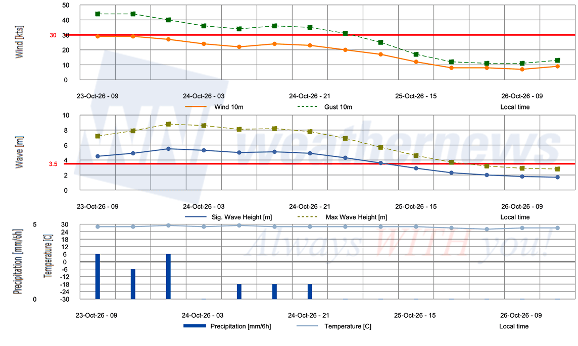
■ ISHIGAKI, Okinawa, Japan
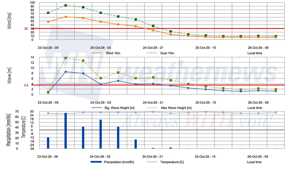
■ KEELUNG, Taiwan
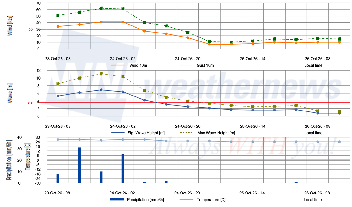
■ HUALIEN, Taiwan
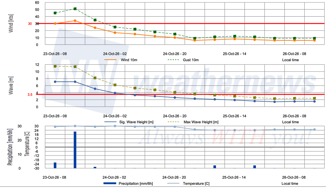
Weathernews Inc. assumes no liability for navigational decisions, losses, or damages resulting from reliance on this general overview.
While official observations guide the general threat assessment, highly detailed, proprietary routing and port forecasts are essential for safe navigation. Weathernews services provide customers with 24/7 localized data to ensure your vessels remain safe and well-informed. Please consult our dedicated services for the most up-to-date, detailed predictions for your specific routes and operations.
Note on the storm's name: "Champi" is drawn from the Western North Pacific and South China Sea tropical cyclone name list, contributed by Laos, and refers to the white champaca flower or plumeria. The WMO and the ESCAP/WMO Typhoon Committee adopt these names sequentially to make tracking specific storms straightforward and to quickly communicate warnings. To learn more about how storms are named, please visit the World Meteorological Organization (WMO) website.