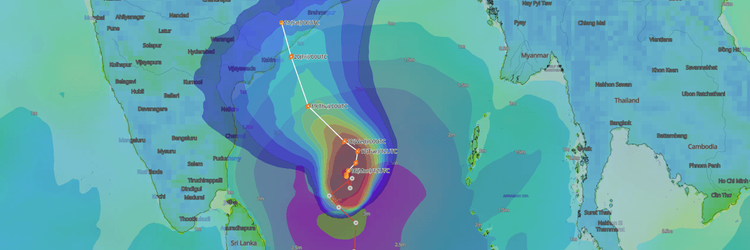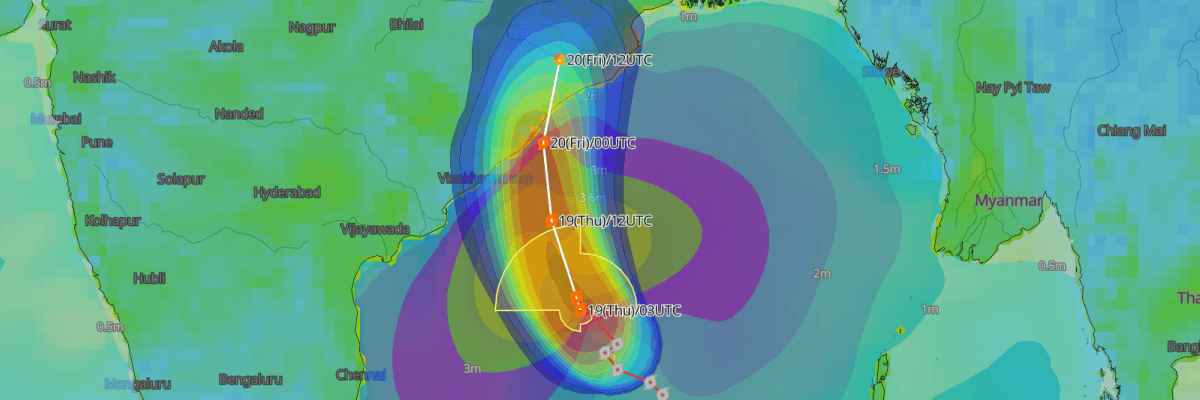
Severe Cyclonic Storm Akvan (formerly Tropical Depression 92B) is forecast to cross the North Andhra Pradesh and South Odisha coasts near Gopalpur, India by 06:30 UTC on 20 November. A Red Message cyclone warning is issued and gale-force winds, extremely heavy rain, and dangerous storm surge at landfall are to be expected.
CURRENT STATUS
Based on the latest IMD observations on November 19, 2026 00:00 UTC
- Location: 14.5°N, 85.3°E — approximately 440 km east-southeast of Narsapur and 530 km south of Gopalpur, Odisha
- Classification: Severe Cyclonic Storm (SCS)
- Movement: North at 12 km/h (6 kt)
- Central pressure: 998 hPa
- Maximum sustained winds: 49 to 54 kt (90 to 100 km/h), gusting to 59 kt (110 km/h)
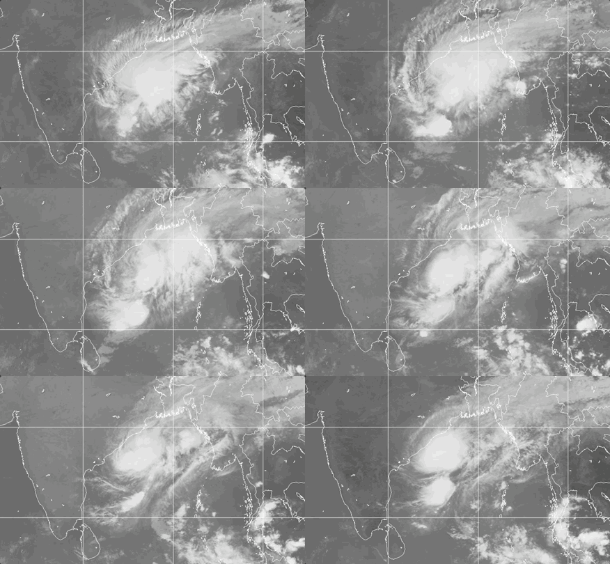
Weathernews Global Composite Satellite Imagery valid November 18, 2026 05:30 UTC to November 19, 2026 05:30 UTC
FORECAST TRACK SUMMARY
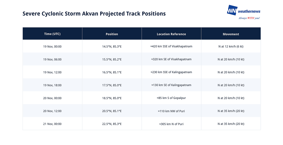
Shipping, port, and offshore operators in the Bay of Bengal should follow Akvan closely as it moves north toward the Andhra Pradesh and Odisha coasts. The forecast positions below show the storm passing close to Gopalpur on 20 November, with gale-force winds and very high seas expected until landfall.
INTENSITY FORECAST
Akvan is expected to remain a Severe Cyclonic Storm until landfall. Slight weakening is expected before the coast as cold, dry air and wind shear move into the system. After landfall, the storm is expected to weaken rapidly, becoming a Deep Depression by 12:00 UTC on 20 November and a Well Marked Low Pressure Area by 00:00 UTC on 21 November.
IMPACTS & THREATS
Akvan is expected to bring life-threatening conditions to coastal Andhra Pradesh and Odisha through landfall on 20 November, along with dangerous seas across the western Bay of Bengal.
Strong Winds: Gale-force winds of 49 to 54 kt (90 to 100 km/h), gusting to 59 kt (110 km/h), are forecast across the westcentral Bay of Bengal until landfall. Along and off the North Andhra Pradesh and Yanam coasts, winds of 49 to 54 kt (90 to 110 km/h) are expected from the morning of 19 November until landfall. Major damage is possible to thatched and kutcha houses, roof tops may blow off, and large trees may be uprooted.
Storm Surge: A storm surge of 0.5 to 1.0 metres above astronomical tide is very likely to inundate low-lying areas of West Godavari, Konaseema, Kakinada, Vizianagaram, Srikakulam, and Visakhapatnam districts in Andhra Pradesh, and Ganjam and Puri districts in south coastal Odisha, during landfall.
Heavy Rainfall and Flooding: Extremely heavy rainfall of 21 cm or more is likely over north coastal Andhra Pradesh and south Odisha on 19 and 20 November. Flash flood risk is low to moderate over several Odisha and Gangetic West Bengal districts until 00:00 UTC on 20 November. Riverine, urban, and coastal flooding are possible, and landslides are possible in hilly areas.
Sea Conditions: Seas in the westcentral Bay of Bengal are expected to remain very high until landfall. Waves of 9 to 14 metres are forecast from 19 November, becoming phenomenal, with waves above 14 metres, from the night of 19 November until landfall. Along the North Andhra Pradesh and South Odisha coasts, seas are expected to be high to very high from the morning of 19 November until landfall.
Shipping and Fishing: Fishermen are advised not to venture into the Southwest Bay of Bengal until 20 November or the Westcentral Bay of Bengal until 21 November, and recommends a total suspension of fishing operations in these areas. Movement of boats and ships is unsafe, and total suspension is recommended of offshore and onshore operations. Port, shipping, and offshore operators should review their preparedness and expect restrictions on weather-sensitive activities through 20 November.
OPERATIONAL PORT FORECASTS
■ GOPALPUR, Odisha, India
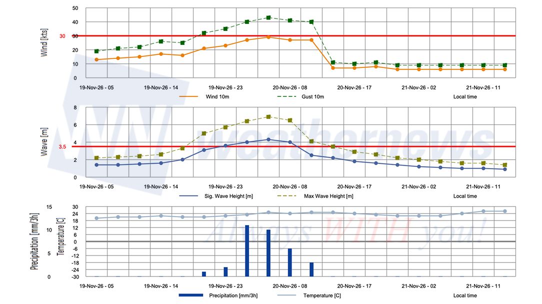
■ PARADIP, Odisha, India
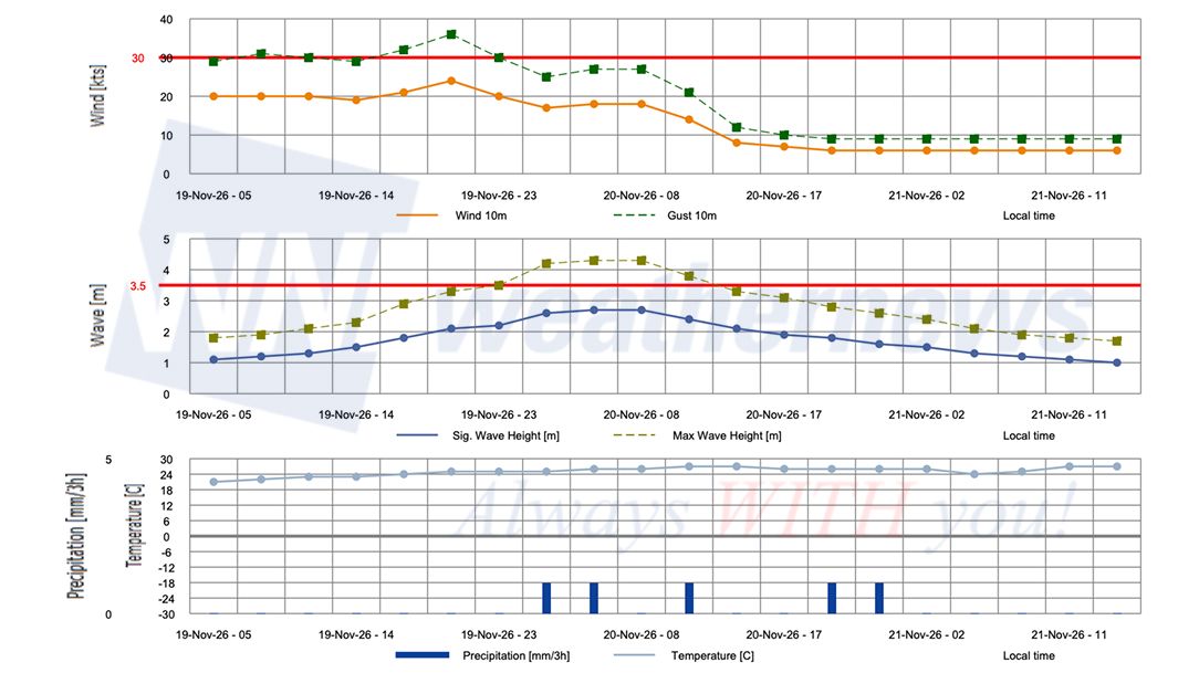
■ VISAKHAPATNAM, Andhra Pradesh, India
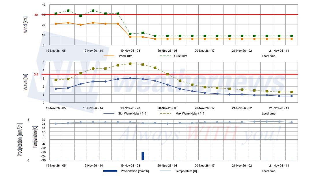
Weathernews Inc. assumes no liability for navigational decisions, losses, or damages resulting from reliance on this general overview.
While official observations guide the general threat assessment, highly detailed, proprietary routing and port forecasts are essential for safe navigation. Weathernews services provide customers with 24/7 localized data to ensure your vessels remain safe and well-informed. Please consult our dedicated services for the most up-to-date, detailed predictions for your specific routes and operations.
Note on system designation: The name "Akvan" was contributed by Iran and refers to Akvan-e Div, a shapeshifting demon from the Persian epic Shahnameh who takes the form of a violent wind and storm.The WMO and the ESCAP/WMO Panel on Tropical Cyclones adopt these names sequentially to make tracking specific storms straightforward and to quickly communicate warnings. To learn more about how storms are named, please visit the World Meteorological Organization (WMO) website.