
2026 Outlook for Southwest Indian Ocean Monsoon
The Southwest Indian Ocean Monsoon for 2026 is expected to be below normal throughout the season. Based on the latest multi-model forecasts and climate indicators, a developing El Niño in the tropical Pacific is set to be the dominant influence — suppressing convection over the eastern Indian Ocean, introducing persistent easterly wind anomalies, and weakening the monsoon circulation, particularly across the southern Arabian Sea.
Monsoon onset is projected to occur on time or later than average, with conditions suggesting the monsoon may take longer to fully establish itself. Similarly, the withdrawal is expected to be near normal or early, with the possibility of the monsoon ending by mid-September — a shorter and subdued season for maritime conditions across the region.
How Does This Compare to 2025?
Last year's monsoon was a markedly different story. ENSO-neutral conditions, warm Indian Ocean sea surface temperatures, and favourable pressure gradients produced an early onset on May 24 and rainfall reaching 108% of LPA — though the withdrawal came earlier than expected on September 14, three days ahead of the climatological average.
The contrast with 2026 is striking — and largely driven by the shift from ENSO-neutral to El Niño conditions:
With these dynamics in mind, the following sections detail the forecast drivers, wind patterns, and timing expectations for the 2026 monsoon season.
Rainfall Outlook from IMD
The India Meteorological Department (IMD) has projected monsoon season rainfall for 2026 to be below normal. This stands in contrast to last year's forecast of 105% of LPA.
The below-normal rainfall projection for 2026 is consistent with the broader climate signals pointing toward El Niño development, which historically suppresses Indian monsoon rainfall by disrupting the Walker Circulation and shifting convective activity eastward over the Pacific.
For maritime operations across the Indian Ocean, a weaker rainfall season typically correlates with reduced monsoon wind intensity, particularly in the southern Arabian Sea — a factor that may influence voyage planning and weather routing decisions during the core monsoon months.
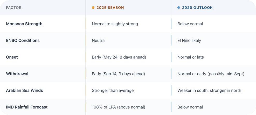
Wind Forecasts from Seasonal Models
Using multi-model ensemble (MME) data initialised in April 2026, we evaluated surface wind anomalies across the Arabian Sea and broader Indian Ocean region. The analysis reveals a persistent north-south asymmetry: winds over the northern Arabian Sea are expected to be stronger than normal, while the south is forecast to weaken progressively — becoming particularly pronounced by September.
These forecasts suggest a tentative onset, a mid-season that struggles to fully establish across the basin, and an early fading of the monsoon flow.
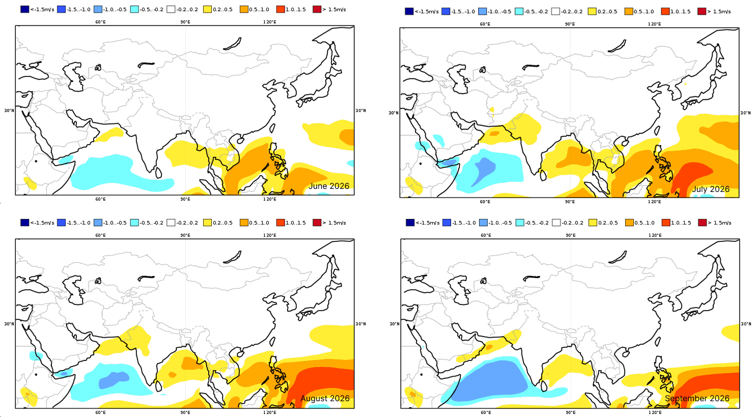
Figure 1: Projected 10-meter wind speed anomaly at ground level for June - September 2026 (Exhibit: Copernicus Climate Service (C3S))
Comparison with Similar Years
To contextualise the 2026 forecast, we examined past years with comparable climate signatures — specifically those featuring developing El Niño conditions and similar sea surface temperature distributions. The selected analog years — 2018, 2015, 2009, 2002, and 1997 — consistently produced below-normal monsoon seasons, both in terms of wind strength and precipitation totals.
Figure 2: Distribution of monsoon wind speeds in the Indian Ocean (June-September average) for normal years (left panel) and similar years (right panel). NCEP/NCAR reanalysis data (obtained from NOAA Earth System Research Laboratory)
Key Climate Drivers Supporting the Forecast
Sea Surface Temperatures (SSTs)
Multi-model forecasts indicate that sea surface temperatures in the Indian Ocean are expected to be near normal or below normal in the east, while remaining above normal in the western Indian Ocean.
The resulting SST pattern favours suppressed convection and dominant large-scale subsidence over the eastern Indian Ocean, leading to higher-than-normal pressure in that region. Meanwhile, convection is likely to become more active in the western Indian Ocean, producing relatively lower-than-normal pressure — but not enough to offset the broader weakening signal.
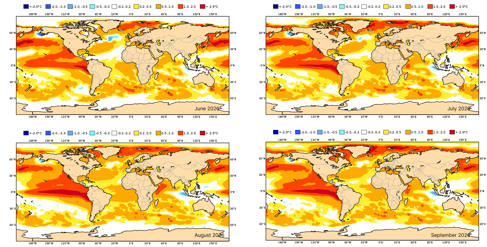
Figure 3: Sea surface temperature anomaly forecast for June–September 2026 (Exhibit: Copernicus Climate Change Services (C3S))
ENSO Conditions
The most consequential climate driver for the 2026 monsoon is the high likelihood of El Niño developing during the season. As detailed in our recent analysis, the 2025–2026 La Niña is officially ending, with a growing 60% likelihood that El Niño will emerge by the Northern Hemisphere summer — with Niño 3.4 sea surface temperature anomalies expected to exceed the +0.5°C threshold.
El Niño's impact on the Indian monsoon is well-documented: it suppresses convection over the eastern Indian Ocean, and introduces easterly wind anomalies that directly oppose the prevailing southwesterly monsoon flow — weakening it particularly across the southern Arabian Sea.
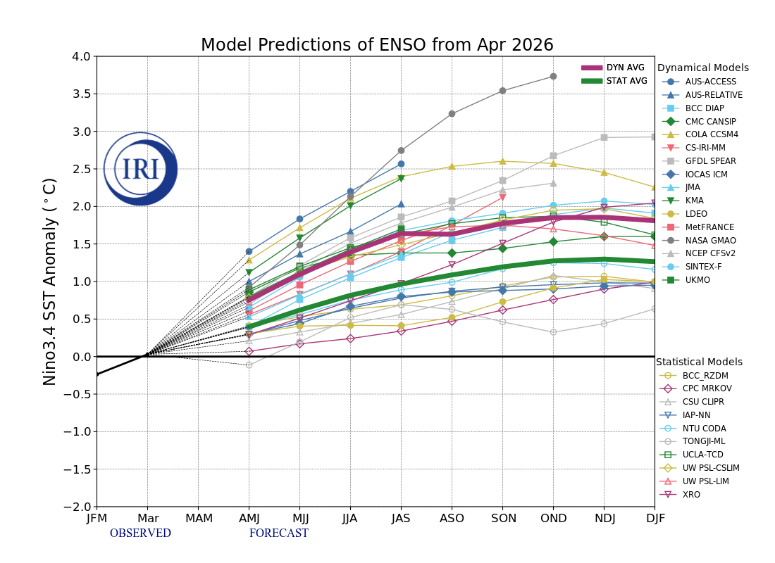
Figure 4: SST anomaly forecasts for the El Niño monitoring area based on country models (IRI summary). Water temperature anomalies of +0.5°C or greater indicate an El Niño event, while water temperature anomalies of -0.5°C or less indicate a La Niña event.
Sea Level Pressure
Consistent with the SST and ENSO outlook, suppressed convection and dominant large-scale subsidence are expected in the eastern Indian Ocean, leading to higher-than-normal surface pressure. In the western Indian Ocean, more active convection is likely to produce relatively lower-than-normal pressure.
However, the net effect of this pressure distribution — combined with El Niño's easterly wind anomalies — is expected to weaken the overall monsoon pressure gradient. Easterly wind anomalies are forecast to persist across the Indian Ocean throughout the season, reducing the strength of the southwesterly monsoon flow.
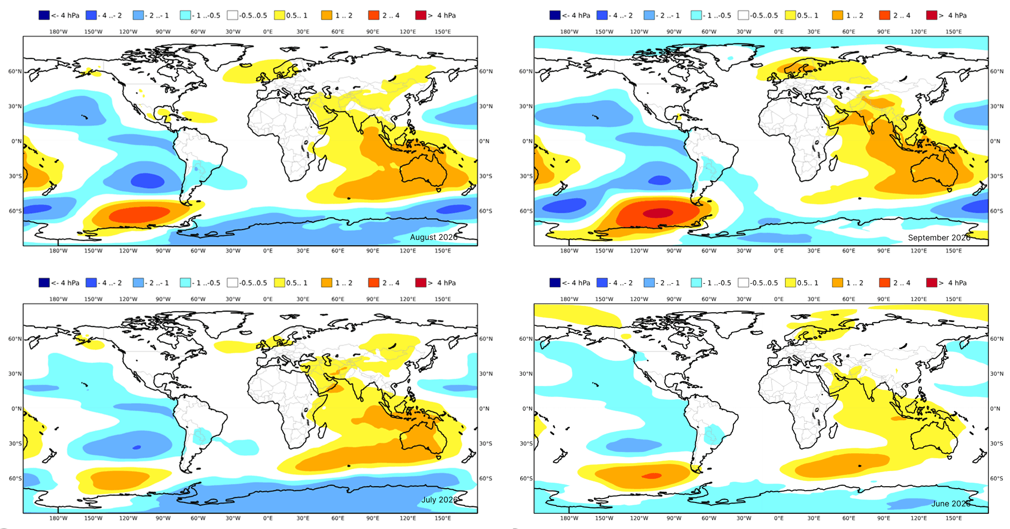
Figure 5: Sea surface pressure anomaly forecast for June–September 2026 (Exhibit: Copernicus Climate Change Services (C3S))
Eurasian Snow Cover
Snow cover across the Northern Hemisphere and Eurasia from January to March 2026 was smaller than normal. While reduced snow cover would ordinarily support an earlier and stronger monsoon, the large-scale suppression of convection driven by El Niño — alongside a positive Indian Ocean Dipole (IOD), which reinforces warmer waters in the western Indian Ocean and cooler conditions in the east — is likely to negate this effect.
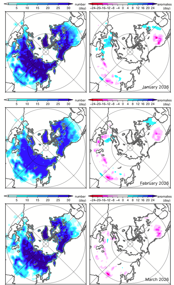
Figure 6: Snow cover duration over the Northern Hemisphere (left/days, right/anomaly) (Exhibit: Japan Meteorological Agency). The snow cover area over the Northern Hemisphere and Eurasia from January to March 2026 was smaller than normal.
Monsoon Onset Outlook
Through late May, sea surface temperatures in the Arabian Sea are expected to be generally above normal. Meanwhile, temperatures in the Middle East and India — particularly in northern India — are forecast to be near or below normal. These conditions indicate that the land-sea thermal contrast in May will be near normal or smaller than in recent years, suggesting that the monsoon onset may be near normal or delayed.
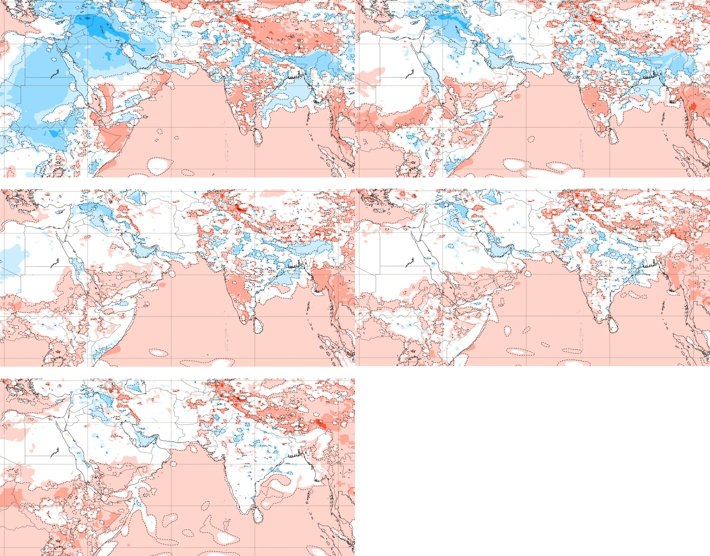
Figure 7: Surface temperature anomaly forecast for May 2026 (Exhibit: ECMWF). Through late May, sea surface temperatures in the Arabian Sea are expected to be generally above normal, while temperatures in the Middle East and India — particularly in northern India — are forecast to be near or below normal, indicating a near-normal or smaller-than-usual land-sea thermal contrast.
Monsoon Withdrawal Outlook
The anticipated early withdrawal is consistent with the weaker overall monsoon circulation forecast for 2026. With El Niño suppressing convective activity and easterly wind anomalies reducing the strength of the southwesterly flow, the monsoon is expected to lose momentum earlier than usual, particularly in the northern and central Indian Ocean.
Based on these factors, the monsoon withdrawal this year is expected to be near normal or early, with the possibility of ending by mid-September.