The 2026 Southern Ocean Outlook at a Glance
Storm activity in the Southern Ocean for June through August 2026 is expected to follow a distinct pattern driven by shifting atmospheric pressure anomalies across key maritime regions.
Vessels transiting the South Pacific and South Atlantic should prepare for above-average storm activity, while routes through the South Indian Ocean and around Cape Horn are expected to see calmer-than-normal conditions. Notably, this pattern remains consistent across all three months — operators can plan around the same regional distribution of storm risk throughout the entire June–August period.
Southern Ocean Storm Trends
June 2026
Lower-than-average atmospheric pressure is predicted in the South Pacific Ocean and the western South Atlantic Ocean, making severe weather more likely. Higher-than-average pressure is expected from the South Indian Ocean to around Australia and around Cape Horn, where severe weather is forecast to be less frequent.
This marks a notable shift from the July–September 2025 season, when the Tasman Sea was among the primary storm areas — in 2026, that region is expected to see comparatively calmer conditions.
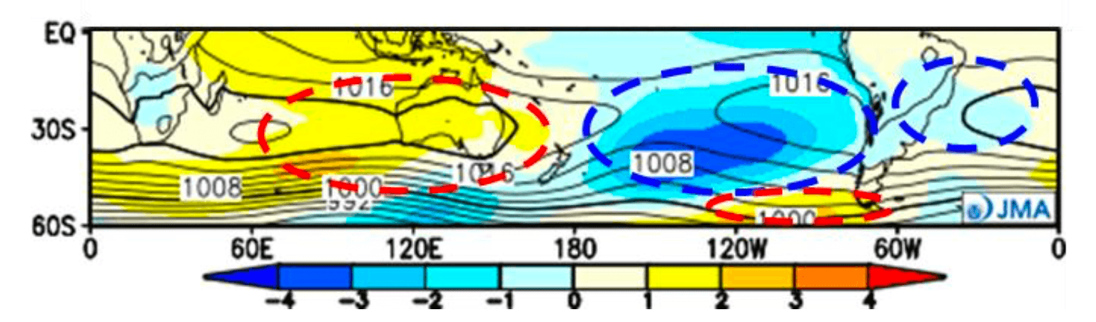
Fig.1 Monthly sea level pressure anomaly simulation for Jun. 2026 (JMA) ※Yellow indicates higher pressure, and blue indicates lower pressure compared with normal year: (hPa)
July 2026
Low atmospheric pressure persists across the South Pacific Ocean and South Atlantic Ocean, maintaining an elevated likelihood of severe weather. Higher-than-average pressure continues from the South Indian Ocean to around Australia and around Cape Horn, keeping severe weather below average in those areas.
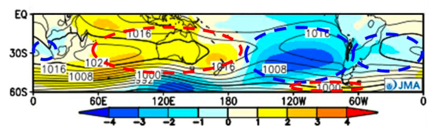
Fig.2 Monthly sea level pressure anomaly simulation for Jul. 2026 (JMA)
August 2026
The pressure pattern from July remains largely unchanged, with above-average storm activity continuing across the South Pacific and South Atlantic. Conditions from the South Indian Ocean to around Australia and around Cape Horn are again expected to see fewer severe weather events than average.
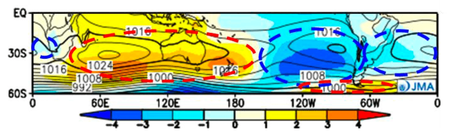
Fig. 3 Monthly sea level pressure anomaly simulation for Aug. 2026 (JMA)
Normal Year Conditions in Southern Ocean

Fig.4 The mean significant wave height of the past five years (WNI analysis). (Top) June; (Middle) July; (Bottom) August
These baseline conditions help maritime professionals understand how the forecast period compares to typical Southern Ocean weather patterns.
Frequently Asked Questions
Q: Why is the Southern Ocean important for global shipping?
The Southern Ocean — spanning the waters around South Africa, Australia, and South America — connects major trade flows between these regions and Asia. As winter takes hold in the Southern Hemisphere, low-pressure systems become more active and sea conditions more challenging, making accurate seasonal forecasts essential for safe and efficient voyage planning. Weather disruptions in the region can affect vessel routing, fuel consumption, transit times, and maritime safety across international shipping networks.
Q: Which Southern Ocean shipping routes face the highest storm risk in 2026?
The South Pacific and South Atlantic sectors of the Southern Ocean are expected to experience above-average storm activity during June–August 2026. This includes the Brazil–Argentina coastal corridor, transoceanic routes between Australia and South America, and North America–South Africa crossings through the South Atlantic. Vessel operators in these areas should anticipate more frequent severe weather events during this period.
Q: How could El Niño affect Southern Ocean weather in 2026?
The 2026 Southern Ocean storm outlook coincides with a likely transition toward El Niño conditions later in the year. El Niño can influence wind patterns, storm tracks, and wave activity across global oceans. For a deeper dive into what this means for global maritime routing in 2026, see our April climate outlook.