An Inland-Centered Quake
At 07:34 local time (12:34 UTC) on August 10, a magnitude 7.4 earthquake struck 5 km south of San José del Palmar, Colombia, at a depth of roughly 110 km. As the earthquake occurred deep inland, the primary seismic impact was away from the coastline with no tsunami threat confirmed by Colombia's Maritime Authority (DIMAR).
The impact for the maritime operation status, thus diverged from established disaster benchmarks such as Kumamoto or Venezuela, where port disruptions were caused by direct coastal damage and marine hazards. According to CMA CGM, Buenaventura port in the Pacific Coast—the closest major maritime hub to the quake remained intact, yet terminal operations were severely restricted by inland conditions instead.
The Real Bottleneck Isn't the Port, But the Road
Colombia diverges from the Kumamoto and Venezuela earthquakes in one key way: in those events, the damage was to the port itself, a berth, a breakwater. In Colombia, the disruption at Buenaventura port, the country's main Pacific-coast port and the closest major port to the epicenter, centered instead on the road connecting it to its customer base: the Cali–Buenaventura corridor.
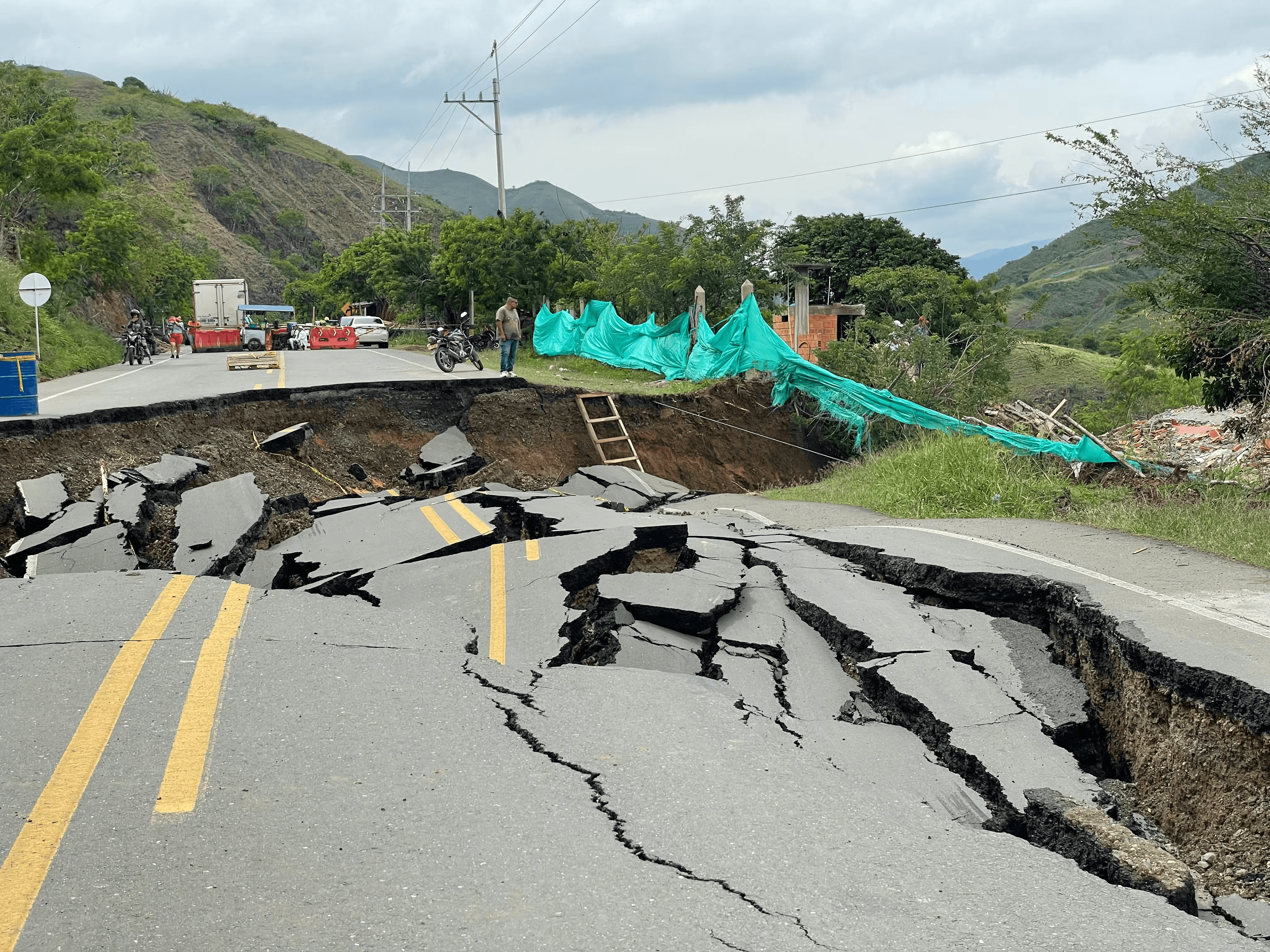
Cali-Buenaventura. Photo by W Radio. Source: https://www.wradio.com.co/2022/11/08/paso-vehicular-en-la-via-cali-
buenaventura-se-habilitaria-en-30-dias/
CMA CGM's operational update reported on August 14 that terminal operations at Buenaventura had only partially resumed, with vessel operations handled under constrained conditions. Yard utilization remained "critically high," resulting in severe space limitations. Staffing shortages continued to affect operational productivity, as part of the local workforce remained unavailable. Empty container returns were being impacted by restricted terminal access and congestion. The corridor itself had not yet been fully restored due to ongoing landslides and infrastructure instability.
By August 20, according to a situation report from A&A Multiprime, that picture had improved significantly. The corridor had gained controlled passage for all vehicle types, including cargo trucks. The port reported progressive recovery and was operating across all cargo types, containerized, general cargo, RoRo, and liquid bulk. The port's bulk-storage silos, taken out of service for structural inspection after the quake, were being progressively brought back into service as of that date.
However, recovery wasn't complete: the trucking sector serving the port draws primarily on operators based in Valle del Cauca, one of the departments hit hardest by the earthquake, and had not yet fully resumed operations, since many operators were themselves directly affected. The port was described as operationally active, with discharge rates below normal driven by trucking availability and the phased return of silo storage, not by damage to the port's own berths or quay infrastructure.
What The AIS Data Shows
Internal AIS tracking from Weathernews shows that daily unique vessel counts at the Port of Buenaventura remained steady between July 27 and August 24, 2026. Throughout the five-week observation window, including the two weeks following the earthquake, vessel numbers held consistently within the high-30s to low-50s.
As of August 24, the count stood at 39 vessels, well within that normal range. Roughly the same number of ships stayed in the area throughout the entire window. AIS data provides a reliable picture of offshore vessel activity, confirming that ships continued calling at the port as usual.
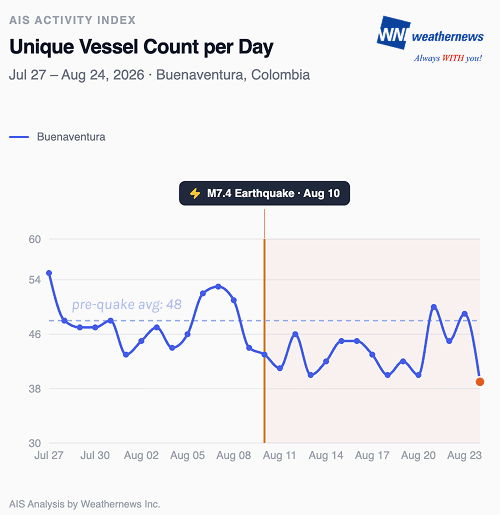
These steady vessel counts, however, did not equate to normal port performance. As detailed in a situation report from A&A Multiprime, the port remained operationally active, but discharge rates fell below standard levels due to landside logistics constraints—specifically limited trucking availability and the phased reinstatement of silo storage. Structural infrastructure at the berths remained undamaged, allowing ship arrivals to proceed as planned while landside logistics faced temporary delays.
What to Watch
- Trucking sector recovery in Valle del Cauca — while the Cali–Buenaventura corridor itself has reopened, the truck operators serving it—many of whom were directly affected by the earthquake, have not yet fully resumed operations. This is now the binding constraint on discharge rates.
- Silo storage reinstatement — bulk storage silos are being progressively brought back into service; full restoration will determine when solid-bulk cargo can move beyond direct-to-truck discharge.
- Discharge rate normalization — vessels calling at Buenaventura should anticipate rates below pre-earthquake levels until trucking and silo capacity are fully restored.
- Residual corridor restrictions — the Cali–Buenaventura corridor remains subject to controlled or restricted passage at certain points, continued contingency planning for delays is advised.
What We Know — and Why It's Limited
Chocó sits on the Nazca plate subduction zone, one of South America's most seismically active regions—the same zone that produced the 1906 Colombia-Ecuador earthquake, among the largest ever recorded. On August 10, that same geological fault system ruptured at magnitude 7.4, Colombia's strongest earthquake in over a decade, prompting a national disaster declaration.
As of August 23, Colombia's National Unit for Disaster Risk Management (UNGRD) reported 329 dead, 4,600 injured, and 234 people missing. With 156,994 families affected and Housing damage reached 175,397 homes damaged and 31,450 destroyed, alongside 5,884 buildings damaged and 574 collapsed. Infrastructure impacts extended well beyond housing: 430 roads, 5 airports, 115 water supply systems, and 85 bridges (70 vehicle, 15 pedestrian) were affected, alongside 378 health centers, 3,726 educational facilities, and 4,248 community centers. Destruction was concentrated inland across 16 departments in the Pacific region, central Andes, and coffee heartland rather than along the coast.
This inland footprint shapes how the disaster affects maritime logistics. AIS data confirms that port operations at Buenaventura remained active; however, landside connectivity plays an equally critical role in overall throughput. In this context, ground reporting on landslide damage along the Cali–Buenaventura corridor provides the crucial visibility needed to reveal the full operational picture.
Disclaimer: The banner image is a stock photograph used for illustrative purposes and is not associated with or taken at the event described in this article.