
Storm Trend Outlook
Updated Storm Trend Outlook – January to March 2025 (North Pacific & North Atlantic)
At Weathernews, we continually refine our understanding of global storm patterns to provide accurate and timely insights. Our updated Storm Trend Outlook for January to March 2025 highlights the latest developments and forecasts for the North Pacific and North Atlantic regions.
1. North Atlantic Storm Trend Outlook
January 2025
- Higher-than-normal pressure is predicted between Bermuda and the Azores, strengthening the Azores High.
- Low pressure develops over the United States and the high latitudes of the Atlantic, bringing stormy weather to the eastern North Atlantic and Gulf of Mexico.
- The Mediterranean experiences more stormy weather than usual due to lower-than-average atmospheric pressure.
- Monthly sea level pressure anomaly simulation for Jan. 2025 (JMA)
- ※Yellow indicates higher pressure, and blue indicates lower pressure compared with the normal year. Unit: hPa
Industry Insights: Expect increased storm activity in the eastern North Atlantic and Gulf of Mexico, while the Mediterranean faces above-average storms due to lower-than-average pressure in the region.
February 2025
- Higher-than-normal atmospheric pressure is forecast in Europe, with lower pressure expected in North America and around the Azores.
- High pressure in the Atlantic Ocean will be weaker than normal, leading to more frequent stormy weather in eastern North America and the eastern Atlantic.
- Mediterranean conditions remain typical, with storm activity following seasonal patterns.
- Fig.2 Monthly sea level pressure anomaly simulation for Feb. 2025 (JMA)
- Unit: hPa
Industry Insights: Increased storm frequency is expected in eastern North America and the eastern Atlantic, while Mediterranean conditions remain stable, with typical storm activity.
March 2025
- The Azores High remains weaker than normal, with lower-than-normal pressure continuing in North America and around the Azores.
- More severe weather is likely in eastern North America and the eastern Atlantic, with stormy conditions more frequent than usual.
- Mediterranean conditions will be calmer, with higher-than-normal pressure expected in the region.
- Fig. 3 Monthly sea level pressure anomaly simulation for Mar. 2025 (JMA)
- Unit: hPa
Industry Insights: Eastern North America and the eastern Atlantic will experience more severe weather than normal, while the Mediterranean will see calmer conditions with fewer storms due to higher pressure.
Normal Year Conditions in North Atlantic
- Fig.4 The mean significant wave height of the past five years (WNI analysis)
- Unit: m
- (Left) January, 2020-2024
- (Center) February, 2020-2024
- (Right) March, 2020-2024
2. North Pacific Storm Trend Outlook
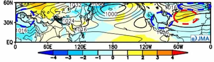
January 2025
- Lower-than-normal atmospheric pressure is predicted over a wide area from the Russian Far East to the Bering Sea.
- Intensified winter pressure patterns around Japan, with low pressure developing toward the Bering Sea, generating stormy weather in the western and central Pacific.
- The northeast monsoon in the East and South China Seas is expected to be stronger than normal due to lower-than-normal pressure over mainland China and the South China Sea.
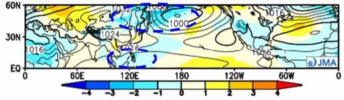
- Fig. 1 Monthly sea level pressure anomaly simulation for Jan. 2025 (JMA)
- ※Yellow indicates higher pressure, and blue indicates lower pressure compared with the normal year. Unit: hPa
Industry Insights: Expect more frequent stormy weather in the western and central Pacific, with a stronger-than-normal northeast monsoon affecting the East and South China Seas.
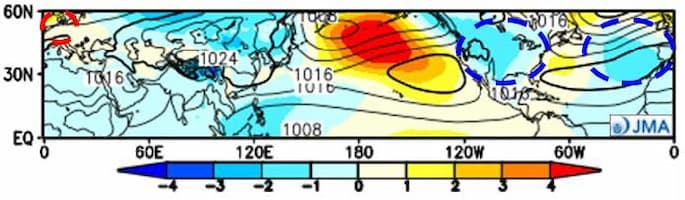
February 2025
- Higher-than-normal pressure is forecast in the central Pacific, while lower pressure is expected from the Russian Far East to Japan and along the west coast of North America.
- Winter pressure patterns will intensify around Japan, and low pressure will develop toward the Kamchatka Peninsula, leading to stormy weather in the western Pacific and western North America.
- The northeast monsoon in the East and South China Seas is expected to remain around normal.
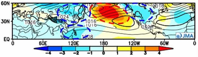
- Fig. 2 Monthly sea level pressure anomaly simulation for Feb. 2025 (JMA)
- Unit: hPa
Industry Insights: Stormy weather is forecast for the western Pacific and western North America, with typical northeast monsoon activity in the East and South China Seas.
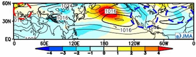
March 2025
- Higher-than-normal pressure persists in the central Pacific, while lower-than-normal pressure continues along the west coast of North America.
- Stormy weather is expected to be more frequent in the western Pacific and western North America.
- Normal conditions are forecast for the northeast monsoon in the East and South China Seas.
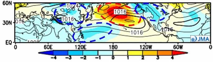
- Fig. 3 Monthly sea level pressure anomaly simulation for Mar. 2025 (JMA)
- Unit: hPa
Industry Insights: Increased storm activity is expected in the western Pacific and western North America, with consistent monsoon patterns in the East and South China Seas.
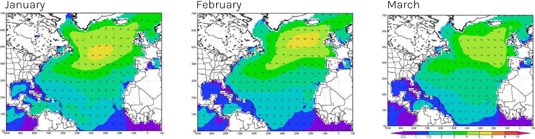
Normal Year Conditions in North Pacific
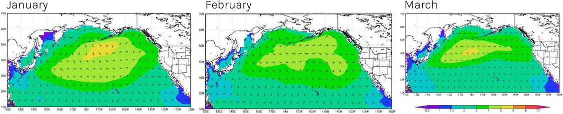
- Fig.4 The mean significant wave height of the past five years (WNI analysis)
- Unit: m
- (Left) January, 2020-2024
- (Center) February, 2020-2024
- (Right) March, 2020-2024